FAA INFORMATION EFFECTIVE 19 MARCH 2026
Location
| FAA Identifier: | NRN |
| Lat/Long: | 39-51-01.7000N 099-53-40.9000W
39-51.028333N 099-53.681667W
39.8504722,-99.8946944
(estimated) |
| Elevation: | 2384 ft. / 726.6 m (surveyed) |
| Variation: | 08E (1990) |
| From city: | 1 mile N of NORTON, KS |
| Time zone: | UTC -5 (UTC -6 during Standard Time) |
| Zip code: | 67654 |
Airport Operations
| Airport use: | Open to the public |
| Activation date: | 07/1947 |
| Control tower: | no |
| ARTCC: | DENVER CENTER |
| FSS: | WICHITA FLIGHT SERVICE STATION |
| NOTAMs facility: | ICT (NOTAM-D service available) |
| Attendance: | MON-FRI 0800-1700 |
| Wind indicator: | lighted |
| Segmented circle: | no |
| Beacon: | white-green (lighted land airport)
Operates sunset to sunrise. |
Airport Communications
| CTAF: | 122.9 |
| WX AWOS-3PT: | 118.275 (785-871-4009) |
- APCH/DEP CTL SVC PRVDD BY DENVER ARTCC (ZDV) ON FREQS 132.7/226.675 (HILL CITY RCAG).
Nearby radio navigation aids
| VOR radial/distance | | VOR name | | Freq | | Var |
|---|
| MCKr115/38.5 | | MC COOK VOR/DME | | 115.30 | | 08E |
| HLCr015/38.7 | | HILL CITY VORTAC | | 113.70 | | 08E |
Airport Services
| Fuel available: | 100LL JET-A JET-A1+
A:FUEL 24 HR SELF-SERVE. |
| Parking: | tiedowns |
| Airframe service: | NONE |
| Powerplant service: | NONE |
Runway Information
Runway 16/34
| Dimensions: | 4701 x 60 ft. / 1433 x 18 m |
| Surface: | concrete, in poor condition
RWY SFC ROUGH DUE TO UNEVEN PAVING JOINTS EVERY 10 FT. |
| Runway edge lights: | high intensity |
| RUNWAY 16 | | RUNWAY 34 |
| Latitude: | 39-51.528073N | | 39-50.782908N |
| Longitude: | 099-53.833647W | | 099-53.561037W |
| Elevation: | 2384.0 ft. | | 2361.9 ft. |
| Traffic pattern: | left | | left |
| Runway heading: | 157 magnetic, 165 true | | 337 magnetic, 345 true |
| Markings: | nonprecision, in good condition | | nonprecision, in good condition |
| Visual slope indicator: | 2-light PAPI on left (3.00 degrees glide path) | | 2-light PAPI on left (3.00 degrees glide path) |
| Runway end identifier lights: | yes | | yes |
| Touchdown point: | yes, no lights | | yes, no lights |
Runway 8/26
| Dimensions: | 2117 x 125 ft. / 645 x 38 m |
| Surface: | turf, in fair condition
SURFACE ROUGH. |
| RUNWAY 8 | | RUNWAY 26 |
| Latitude: | 39-50.750300N | | 39-50.739983N |
| Longitude: | 099-53.874817W | | 099-53.422550W |
| Elevation: | 2348.6 ft. | | 2352.0 ft. |
| Traffic pattern: | left | | left |
| Runway heading: | 084 magnetic, 092 true | | 264 magnetic, 272 true |
| Touchdown point: | yes, no lights | | yes, no lights |
| Obstructions: | 24 ft. trees, 510 ft. from runway, 85 ft. right of centerline, 21:1 slope to clear | | none |
Airport Ownership and Management from official FAA records
| Ownership: | Publicly-owned |
| Owner: | CITY & COUNTY OF NORTON
301 EAST WASHINGTON, P O BOX 272
NORTON, KS 67654
Phone 785-877-5000 |
| Manager: | BRICE RILEY
1226 N STATE ST, PO BOX 272
NORTON, KS 67654
Phone 785-877-2201 |
Additional Remarks
| - | FOR CD CTC DENVER ARTCC AT 303-651-4257. |
| - | NO LINE OF SIGHT BETWEEN RWY ENDS. |
Instrument Procedures
NOTE: All procedures below are presented as PDF files. If you need a reader for these files, you should download the free Adobe Reader.NOT FOR NAVIGATION. Please procure official charts for flight.
FAA instrument procedures published for use from 19 March 2026 at 0901Z to 16 April 2026 at 0900Z.
IAPs - Instrument Approach Procedures |
|---|
| RNAV (GPS) RWY 16 | |
download (226KB) |
| RNAV (GPS) RWY 34 | |
download (223KB) |
| NOTE: Special Alternate Minimums apply | |
download (140KB) |
| NOTE: Special Take-Off Minimums/Departure Procedures apply | |
download (355KB) |
Other nearby airports with instrument procedures:
KPHG - Phillipsburg Municipal Airport (27 nm E)
KHLC - Hill City Municipal Airport (28 nm S)
4D9 - Alma Municipal Airport (30 nm NE)
KOIN - Oberlin Municipal Airport (30 nm W)
KCSB - Cambridge Municipal Airport (30 nm NW)
|
|

Road maps at:
MapQuest
Bing
Google
| Aerial photo |
|---|
WARNING: Photo may not be current or correct
 Photo taken 23-Jul-2006
from about 5500 ft MSL
Photo taken 23-Jul-2006
from about 5500 ft MSL
Do you have a better or more recent aerial photo of Norton Municipal Airport that you would like to share? If so, please send us your photo.
|
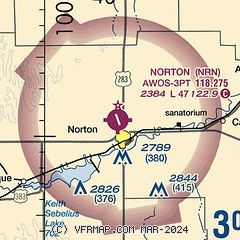
| Sectional chart |
|---|
|
| Airport distance calculator |
|---|
|
|
| Sunrise and sunset |
|---|
|
Times for 02-Apr-2026
| | Local
(UTC-5) | | Zulu
(UTC) |
|---|
| Morning civil twilight | | 06:56 | | 11:56 |
| Sunrise | | 07:23 | | 12:23 |
| Sunset | | 20:03 | | 01:03 |
| Evening civil twilight | | 20:31 | | 01:31 |
|
| Current date and time |
|---|
| Zulu (UTC) | 02-Apr-2026 15:15:54 |
|---|
| Local (UTC-5) | 02-Apr-2026 10:15:54 |
|---|
|
| METAR |
|---|
| KNRN | 021455Z AUTO 32018KT 10SM OVC011 06/04 A2968 RMK AO2
|
|
| TAF |
|---|
KMCK
38nm NW | 021400Z 0214/0312 31012KT P6SM OVC070 TEMPO 0214/0215 4SM BR BKN008 FM021800 27012KT P6SM SKC FM022200 21013G18KT P6SM SKC FM030100 17018G25KT P6SM SKC FM030600 20013KT P6SM SKC
|
|
| NOTAMs |
|---|
NOTAMs are issued by the DoD/FAA and will open in a separate window not controlled by AirNav.
|
|


