FAA INFORMATION EFFECTIVE 27 NOVEMBER 2025
Location
| FAA Identifier: | AIT |
| Lat/Long: | 46-32-54.4630N 093-40-35.8758W
46-32.907717N 093-40.597930W
46.5484619,-93.6766322
(estimated) |
| Elevation: | 1206 ft. / 367.6 m (surveyed) |
| Variation: | 00E (2015) |
| From city: | 2 miles NE of AITKIN, MN |
| Time zone: | UTC -6 (UTC -5 during Daylight Saving Time) |
| Zip code: | 56431 |
Airport Operations
| Airport use: | Open to the public |
| Activation date: | 11/1946 |
| Control tower: | no |
| ARTCC: | MINNEAPOLIS CENTER |
| FSS: | PRINCETON FLIGHT SERVICE STATION |
| NOTAMs facility: | AIT (NOTAM-D service available) |
| Attendance: | APR-OCT 0800-1700, NOV-MAR MON-FRI 0900-1700 |
| Wind indicator: | lighted |
| Segmented circle: | no |
| Lights: | MIRL RWY 16/34 PRESET LOW INTST; ACTVT OR INCR INTST REIL RWY 16 & 34; PAPI RWY 16 & 34; MIRL RWY 16/34 - CTAF |
| Beacon: | white-green (lighted land airport)
Operates sunset to sunrise. |
Airport Communications
| CTAF/UNICOM: | 123.05 |
| WX AWOS-3: | 118.675 (218-927-2101) |
| WX AWOS-3 at HZX (16 nm E): | 119.575 (218-768-2593) |
- APCH/DEP SVC PRVDD BY MINNEAPOLIS ARTCC ON FREQS 118.05/239.0 (BRAINERD RCAG).
Nearby radio navigation aids
| VOR radial/distance | | VOR name | | Freq | | Var |
|---|
| GPZr186/37.7 | | GRAND RAPIDS VOR/DME | | 114.65 | | 06E |
| NDB name | | Hdg/Dist | | Freq | | Var | | ID |
|---|
| RIPLEY | | 041/39.5 | | 404 | | 03E | | XCR | -..- -.-. .-. |
Airport Services
| Fuel available: | 100LL JET-A
100LL:100LL & JET A AVBL H24 VIA CREDIT CARD. FOR SVC CALL 218-839-1067 OR 218-839-6488. |
| Parking: | hangars and tiedowns |
| Airframe service: | MAJOR |
| Powerplant service: | MAJOR |
| Bottled oxygen: | LOW |
| Bulk oxygen: | NONE |
Runway Information
Runway 16/34
| Dimensions: | 4000 x 75 ft. / 1219 x 23 m |
| Surface: | asphalt, in fair condition |
| Weight bearing capacity: | |
| Runway edge lights: | medium intensity |
| RUNWAY 16 | | RUNWAY 34 |
| Latitude: | 46-33.357738N | | 46-32.723768N |
| Longitude: | 093-40.586807W | | 093-40.330968W |
| Elevation: | 1205.7 ft. | | 1205.9 ft. |
| Traffic pattern: | left | | left |
| Runway heading: | 164 | | 344 |
| Markings: | nonprecision, in good condition | | nonprecision, in good condition |
| Visual slope indicator: | 4-light PAPI on left (3.00 degrees glide path) | | 4-light PAPI on left (3.00 degrees glide path) |
| Runway end identifier lights: | yes | | yes |
| Touchdown point: | yes, no lights | | yes, no lights |
| Obstructions: | none | | 96 ft. tree, 1644 ft. from runway, 445 ft. left of centerline, 15:1 slope to clear |
Runway 8/26
| Dimensions: | 3123 x 140 ft. / 952 x 43 m |
| Surface: | turf, in good condition |
| Runway edge markings: | YELLOW CONES. |
| Operational restrictions: | SKI EQUIPPED ACFT ONLY NOV-APR, CALL 218-927-4104 FOR RY CONDS. |
| RUNWAY 8 | | RUNWAY 26 |
| Latitude: | 46-32.724600N | | 46-32.750038N |
| Longitude: | 093-41.147833W | | 093-40.404205W |
| Elevation: | 1203.5 ft. | | 1205.8 ft. |
| Traffic pattern: | left | | left |
| Runway heading: | 087 | | 267 |
| Displaced threshold: | 240 ft. | | no |
| Declared distances: | TORA:3123 TODA:3123 ASDA:3123 LDA:2883 | | |
| Runway end identifier lights: | no | | no |
| Touchdown point: | yes, no lights | | yes, no lights |
| Obstructions: | 38 ft. trees, 676 ft. from runway, 130 ft. left of centerline, 17:1 slope to clear | | 45 ft. trees, 819 ft. from runway, 64 ft. right of centerline, 18:1 slope to clear |
Airport Ownership and Management from official FAA records
| Ownership: | Publicly-owned |
| Owner: | COUNTY & CITY OF AITKIN
109 1ST AVE NW
AITKIN, MN 56431-1397
Phone 218-927-2527 |
| Manager: | JENNIFER THOMPSON
109 1ST AVE NW
AITKIN, MN 56431-1397
Phone 218-927-2527
ARPT OPS DAY 218-839-1067; NGT 218-851-4502. |
Additional Remarks
| A30A-16 | CALM WIND RWY. |
| - | GCO AVBL ON FREQ 121.725 THRU ZMP ARTCC AND PNM FSS. |
| - | FOR CD IF UNA VIA GCO CTC MINNEAPOLIS ARTCC AT 651-463-5588. |
Instrument Procedures
NOTE: All procedures below are presented as PDF files. If you need a reader for these files, you should download the free Adobe Reader.NOT FOR NAVIGATION. Please procure official charts for flight.
FAA instrument procedures published for use from 27 November 2025 at 0901Z to 25 December 2025 at 0900Z.
IAPs - Instrument Approach Procedures |
|---|
| RNAV (GPS) RWY 16 | |
download (245KB) |
| RNAV (GPS) RWY 34 | |
download (272KB) |
| NOTE: Special Alternate Minimums apply | |
download (151KB) |
| NOTE: Special Take-Off Minimums/Departure Procedures apply | |
download (405KB) |
Other nearby airports with instrument procedures:
KHZX - Isedor Iverson Airport (16 nm E)
KBRD - Brainerd Lakes Regional Airport (21 nm SW)
KPWC - Pine River Regional Airport (31 nm W)
KXVG - Longville Municipal Airport (34 nm NW)
KMZH - Moose Lake Carlton County Airport (37 nm E)
|
|

Road maps at:
MapQuest
Bing
Google
| Aerial photo |
|---|
WARNING: Photo may not be current or correct

Do you have a better or more recent aerial photo of Aitkin Municipal Airport - Steve Kurtz Field that you would like to share? If so, please send us your photo.
|
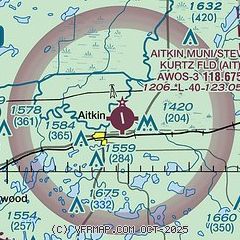
| Sectional chart |
|---|
|
| Airport distance calculator |
|---|
|
|
| Sunrise and sunset |
|---|
|
Times for 30-Nov-2025
| | Local
(UTC-6) | | Zulu
(UTC) |
|---|
| Morning civil twilight | | 07:04 | | 13:04 |
| Sunrise | | 07:38 | | 13:38 |
| Sunset | | 16:29 | | 22:29 |
| Evening civil twilight | | 17:03 | | 23:03 |
|
| Current date and time |
|---|
| Zulu (UTC) | 01-Dec-2025 05:09:23 |
|---|
| Local (UTC-6) | 30-Nov-2025 23:09:23 |
|---|
|
| METAR |
|---|
| KAIT | 010455Z AUTO 00000KT 10SM CLR M11/M15 A3035 RMK AO2
|
KHZX
16nm E | 010455Z AUTO 22003KT 10SM OVC031 M10/M14 A3035 RMK AO2
|
|
| TAF |
|---|
KBRD
21nm SW | 301730Z 3018/0118 32009G15KT 6SM -SN BKN015 TEMPO 3018/3021 3SM -SN FM302300 29005KT P6SM SCT060 FM010900 23004KT P6SM BKN060
|
|
| NOTAMs |
|---|
NOTAMs are issued by the DoD/FAA and will open in a separate window not controlled by AirNav.
|
|

