FAA INFORMATION EFFECTIVE 09 JULY 2026
Location
| FAA Identifier: | BMG |
| Lat/Long: | 39-08-45.6760N 086-37-00.0490W
39-08.761267N 086-37.000817W
39.1460211,-86.6166803
(estimated) |
| Elevation: | 845.5 ft. / 257.7 m (surveyed) |
| Variation: | 02W (1990) |
| From city: | 4 miles SW of BLOOMINGTON, IN |
| Time zone: | UTC -4 (UTC -5 during Standard Time) |
| Zip code: | 47403 |
Airport Operations
| Airport use: | Open to the public |
| Activation date: | 03/1942 |
| Control tower: | yes |
| ARTCC: | INDIANAPOLIS CENTER |
| FSS: | TERRE HAUTE FLIGHT SERVICE STATION |
| NOTAMs facility: | BMG (NOTAM-D service available) |
| Attendance: | 0630-2130 |
| Wind indicator: | lighted |
| Segmented circle: | yes |
| Lights: | WHEN ATCT CLSD ACTVT MALSR RWY 35; REIL RWY 17; PAPI RWY 24; MIRL RWY 06/24; HIRL RWY 17/35 - CTAF. PAPI RWY 17 ON CONSLY. |
| Beacon: | white-green (lighted land airport)
Operates sunset to sunrise. |
| Fire and rescue: | ARFF index A |
| Airline operations: | CLSD TO SKED ACR OPS GTR THAN 9 PAX SEATS. UNSKED ACR OPS GTR THAN 30 PAX SEATS PPR - OPS MGR 812-825-5406 OR 812-606-6659 AT NIGHT OR ON WKEND & HOL. INDEX B ARFF CAPABILITY AVBL ON REQ. |
Airport Communications
| CTAF: | 120.775 |
| UNICOM: | 122.95 |
| WX ASOS: | 134.525 (812-200-0732) |
| BLOOMINGTON GROUND: | 121.9 [0630-2130] |
| BLOOMINGTON TOWER: | 120.775 [0630-2130] |
| HULMAN APPROACH: | 128.025 |
| HULMAN DEPARTURE: | 128.025 |
| EMERG: | 121.5 |
Nearby radio navigation aids
| VOR radial/distance | | VOR name | | Freq | | Var |
|---|
| OOM at field | | HOOSIER VORTAC | | 110.20 | | 02W |
| TTHr123/35.8 | | TERRE HAUTE VORTAC | | 115.30 | | 02E |
Airport Services
| Fuel available: | 100LL JET-A |
| Parking: | hangars and tiedowns |
| Airframe service: | MAJOR |
| Powerplant service: | MAJOR |
| Bottled oxygen: | HIGH/LOW |
Runway Information
Runway 17/35
| Dimensions: | 6500 x 150 ft. / 1981 x 46 m |
| Surface: | asphalt/grooved, in good condition |
| Weight bearing capacity: | | Single wheel: | 120.0 | | Double wheel: | 208.0 | | Double tandem: | 308.4 | | Dual double tandem: | 816.8 |
|
| Runway edge lights: | high intensity |
| RUNWAY 17 | | RUNWAY 35 |
| Latitude: | 39-09.492073N | | 39-08.432790N |
| Longitude: | 086-37.088215W | | 086-36.888535W |
| Elevation: | 845.5 ft. | | 837.7 ft. |
| Traffic pattern: | left | | left |
| Runway heading: | 174 magnetic, 172 true | | 354 magnetic, 352 true |
| Markings: | nonprecision, in good condition | | precision, in good condition |
| Visual slope indicator: | 4-light PAPI on left (3.00 degrees glide path) | | |
| Approach lights: | | | MALSR: 1,400 foot medium intensity approach lighting system with runway alignment indicator lights |
| Runway end identifier lights: | yes | | no |
| Touchdown point: | yes, no lights | | yes, no lights |
| Instrument approach: | | | ILS |
| Obstructions: | 60 ft. tree, 2600 ft. from runway, 1100 ft. right of centerline, 40:1 slope to clear | | none |
Runway 6/24
| Dimensions: | 3798 x 100 ft. / 1158 x 30 m |
| Surface: | asphalt/grooved, in fair condition |
| Weight bearing capacity: | | PCN 4 /F/D/X/U | | Single wheel: | 35.0 | | Double wheel: | 50.0 |
|
| Runway edge lights: | medium intensity |
| Operational restrictions: | RWY 06/24 NOT AVBL FOR PART 121/PART 380 OPS WITH SKED PAX CARRYING OPS MORE THAN 9 PAX SEATS AND NON-SKED PAX CARRYING OPS MORE THAN 30 PAX SEATS. AVBL ACR TAX ONLY. |
| RUNWAY 6 | | RUNWAY 24 |
| Latitude: | 39-08.268280N | | 39-08.565622N |
| Longitude: | 086-37.375497W | | 086-36.668743W |
| Elevation: | 832.1 ft. | | 840.6 ft. |
| Traffic pattern: | left | | left |
| Runway heading: | 064 magnetic, 062 true | | 244 magnetic, 242 true |
| Displaced threshold: | 304 ft. | | 222 ft. |
| Markings: | nonprecision, in good condition | | nonprecision, in good condition |
| Visual slope indicator: | | | 4-light PAPI on left (4.00 degrees glide path) |
| Runway end identifier lights: | no | | no |
| Touchdown point: | yes, no lights | | yes, no lights |
| Obstructions: | 22 ft. road, 200 ft. from runway, 204 ft. right of centerline
ROAD 100-200 FT FM THR 200-250 FT R. | | 18 ft. road, 200 ft. from runway, 100 ft. left of centerline
7 FT FENCE 175 FT FM THR 113 FT L OF RWY EXTDD CTRLN. |
Airport Ownership and Management from official FAA records
| Ownership: | Publicly-owned |
| Owner: | MONROE COUNTY
972 SOUTH KIRBY ROAD
BLOOMINGTON, IN 47403
Phone 812-825-5406 |
| Manager: | CARLOS LAVERTY
972 S. KIRBY RD
BLOOMINGTON, IN 47403
Phone 812-825-5406 |
Additional Remarks
| A39-17/35 | PCR VALUE: 568/F/C/X/T |
| - | SFC COND UNMNT MON-FRI 1600-0800 & WKEND. |
| - | FOR CD CTC HULMAN APCH AT 812-877-7581. |
Instrument Procedures
NOTE: All procedures below are presented as PDF files. If you need a reader for these files, you should download the free Adobe Reader.NOT FOR NAVIGATION. Please procure official charts for flight.
FAA instrument procedures published for use from 09 July 2026 at 0901Z to 06 August 2026 at 0900Z.
IAPs - Instrument Approach Procedures |
|---|
| ILS OR LOC/DME RWY 35 | |
download (280KB) |
| RNAV (GPS) RWY 06 | |
download (198KB) |
| RNAV (GPS) RWY 17 | |
download (249KB) |
| RNAV (GPS) RWY 24 | |
download (212KB) |
| RNAV (GPS) RWY 35 | |
download (291KB) |
| NOTE: Special Alternate Minimums apply | |
download (149KB) |
| NOTE: Special Take-Off Minimums/Departure Procedures apply | |
download (164KB) |
Other nearby airports with instrument procedures:
KBFR - Virgil I Grissom Municipal Airport (20 nm SE)
0I2 - Brazil Clay County Airport/Charles B Hall Field (30 nm NW)
KGPC - Putnam County Regional Airport (31 nm N)
KBAK - Columbus Municipal Airport (34 nm E)
KSER - Freeman Municipal Airport (36 nm E)
|
|

Road maps at:
MapQuest
Bing
Google
| Aerial photo |
|---|
WARNING: Photo may not be current or correct
 Photo courtesy of AirNav, LLC
Photo taken 28-Jul-2011
looking west.
Photo courtesy of AirNav, LLC
Photo taken 28-Jul-2011
looking west.
Do you have a better or more recent aerial photo of Monroe County Airport that you would like to share? If so, please send us your photo.
|
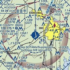
| Sectional chart |
|---|
|
CAUTION: Diagram may not be current
 Download PDF
of official airport diagram from the FAA
| Airport distance calculator |
|---|
|
|
| Sunrise and sunset |
|---|
|
Times for 28-Jul-2026
| | Local
(UTC-4) | | Zulu
(UTC) |
|---|
| Morning civil twilight | | 06:14 | | 10:14 |
| Sunrise | | 06:44 | | 10:44 |
| Sunset | | 21:02 | | 01:02 |
| Evening civil twilight | | 21:32 | | 01:32 |
|
| Current date and time |
|---|
| Zulu (UTC) | 28-Jul-2026 14:01:59 |
|---|
| Local (UTC-4) | 28-Jul-2026 10:01:59 |
|---|
|
| METAR |
|---|
| KBMG | 281353Z 34008KT 10SM OVC011 26/24 A2973 RMK AO2 SLP057 T02610244
|
|
| TAF |
|---|
| KBMG | 281120Z 2812/2912 26007KT P6SM SCT050 BKN100 TEMPO 2812/2813 6SM BR OVC020 FM281400 35009KT P6SM SCT035 FM290300 01006KT P6SM SKC
|
|
| NOTAMs |
|---|
NOTAMs are issued by the DoD/FAA and will open in a separate window not controlled by AirNav.
|
|


