FAA INFORMATION EFFECTIVE 12 JUNE 2025
Location
| FAA Identifier: | DQH |
| Lat/Long: | 31-28-36.2590N 082-51-38.0410W
31-28.604317N 082-51.634017W
31.4767386,-82.8605669
(estimated) |
| Elevation: | 256.5 ft. / 78.2 m (surveyed) |
| Variation: | 06W (2020) |
| From city: | 2 miles S of DOUGLAS, GA |
| Time zone: | UTC -4 (UTC -5 during Standard Time) |
| Zip code: | 31535 |
Airport Operations
| Airport use: | Open to the public |
| Activation date: | 04/1940 |
| Control tower: | no |
| ARTCC: | JACKSONVILLE CENTER |
| FSS: | MACON FLIGHT SERVICE STATION |
| NOTAMs facility: | MCN (NOTAM-D service available) |
| Attendance: | M-F 0800-1700 |
| Wind indicator: | lighted |
| Segmented circle: | yes |
| Lights: | ACTVT MALSR RWY 04; PAPI RWY 04 & 22; MIRL RWY 04/22 - CTAF. |
| Beacon: | white-green (lighted land airport)
Operates sunset to sunrise. |
Airport Communications
| CTAF/UNICOM: | 122.8 |
| WX AWOS-3: | 119.075 (912-383-7258) |
| WX ASOS at AMG (18 nm E): | 118.325 (912-632-8738) |
- APCH/DEP SVC PRVDD BY JACKSONVILLE ARTCC ON FREQS 127.575/269.025 (ALMA RCAG).
Nearby radio navigation aids
| VOR radial/distance | | VOR name | | Freq | | Var |
|---|
| AYSr309/19.9 | | WAYCROSS VORTAC | | 112.40 | | 00E |
| NDB name | | Hdg/Dist | | Freq | | Var | | ID |
|---|
| FITZGERALD | | 115/23.5 | | 362 | | 05W | | SUR | ... ..- .-. |
| HAZLEHURST | | 210/26.5 | | 414 | | 06W | | AZE | .- --.. . |
| BAXLEY | | 246/27.9 | | 376 | | 06W | | BHC | -... .... -.-. |
Airport Services
| Fuel available: | 100LL JET-A+ |
| Parking: | tiedowns |
| Airframe service: | MINOR |
| Powerplant service: | MINOR |
| Bottled oxygen: | NONE |
| Bulk oxygen: | NONE |
Runway Information
Runway 4/22
| Dimensions: | 6000 x 100 ft. / 1829 x 30 m |
| Surface: | asphalt, in good condition |
| Weight bearing capacity: | | PCN 27 /F/C/X/T | | Single wheel: | 26.0 |
|
| Runway edge lights: | medium intensity |
| RUNWAY 4 | | RUNWAY 22 |
| Latitude: | 31-28.210423N | | 31-28.998193N |
| Longitude: | 082-51.983435W | | 082-51.284535W |
| Elevation: | 249.7 ft. | | 255.8 ft. |
| Traffic pattern: | left | | left |
| Runway heading: | 043 magnetic, 037 true | | 223 magnetic, 217 true |
| Markings: | precision, in fair condition | | precision, in fair condition |
| Visual slope indicator: | 2-light PAPI on left (3.00 degrees glide path) | | 2-light PAPI on left (2.50 degrees glide path) |
| Approach lights: | MALSR: 1,400 foot medium intensity approach lighting system with runway alignment indicator lights | | |
| Touchdown point: | yes, no lights | | yes, no lights |
| Instrument approach: | LOC/GS | | |
| Obstructions: | 57 ft. trees, 2765 ft. from runway, 877 ft. right of centerline, 45:1 slope to clear | | 52 ft. trees, 1292 ft. from runway, 600 ft. left of centerline, 21:1 slope to clear |
Airport Ownership and Management from official FAA records
| Ownership: | Publicly-owned |
| Owner: | CITY OF DOUGLAS
PO BOX 470
DOUGLAS, GA 31534
Phone 912-389-3401 |
| Manager: | CHRIS DAVIS
CITY OF DOUGLAS PO BOX 470
DOUGLAS, GA 31534
Phone 912-384-1409 |
Additional Remarks
| - | FOR CD CTC JACKSONVILLE ARTCC AT 904-845-1592. |
Instrument Procedures
NOTE: All procedures below are presented as PDF files. If you need a reader for these files, you should download the free Adobe Reader.NOT FOR NAVIGATION. Please procure official charts for flight.
FAA instrument procedures published for use from 12 June 2025 at 0901Z to 10 July 2025 at 0900z.
IAPs - Instrument Approach Procedures |
|---|
| ILS OR LOC RWY 04 **CHANGED** | |
download (225KB) |
| RNAV (GPS) RWY 04 **CHANGED** | |
download (236KB) |
| RNAV (GPS) RWY 22 | |
download (211KB) |
| NOTE: Special Alternate Minimums apply **CHANGED** | |
download (157KB) |
| NOTE: Special Take-Off Minimums/Departure Procedures apply | |
download (189KB) |
Other nearby airports with instrument procedures:
KAMG - Bacon County Airport (18 nm E)
KFZG - Fitzgerald Municipal Airport (24 nm NW)
4J2 - Berrien County Airport (25 nm SW)
KHOE - Homerville Airport (26 nm S)
KAZE - Hazlehurst Airport (27 nm NE)
|
|

Road maps at:
MapQuest
Bing
Google
| Aerial photo |
|---|
WARNING: Photo may not be current or correct

Do you have a better or more recent aerial photo of Douglas Municipal Airport that you would like to share? If so, please send us your photo.
|
| Sectional chart |
|---|
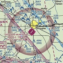
|
| Airport distance calculator |
|---|
|
|
| Sunrise and sunset |
|---|
|
Times for 23-Jun-2025
| | Local
(UTC-4) | | Zulu
(UTC) |
|---|
| Morning civil twilight | | 06:01 | | 10:01 |
| Sunrise | | 06:29 | | 10:29 |
| Sunset | | 20:39 | | 00:39 |
| Evening civil twilight | | 21:07 | | 01:07 |
|
| Current date and time |
|---|
| Zulu (UTC) | 23-Jun-2025 11:14:23 |
|---|
| Local (UTC-4) | 23-Jun-2025 07:14:23 |
|---|
|
| METAR |
|---|
| KDQH | 231055Z AUTO 00000KT 23/22 A3022 RMK AO2 T02280221 PWINO
|
KAMG
19nm E | 231053Z AUTO 00000KT 4SM BR CLR 21/21 A3020 RMK AO2 SLP225 T02110206 $
|
|
| TAF |
|---|
KVAD
35nm SW | 230800Z 2308/2414 09006KT 9999 SKC QNH3016INS BECMG 2315/2316 09010G15KT 9999 SCT040 QNH3010INS BECMG 2400/2401 15006KT 9999 SKC QNH3013INS BECMG 2410/2411 30006KT 9999 SCT020 QNH3015INS TX34/2320Z TN23/2310Z
|
|
| NOTAMs |
|---|
NOTAMs are issued by the DoD/FAA and will open in a separate window not controlled by AirNav.
|
|


