FAA INFORMATION EFFECTIVE 04 SEPTEMBER 2025
Location
| FAA Identifier: | FZG |
| Lat/Long: | 31-41-02.0570N 083-16-15.2530W
31-41.034283N 083-16.254217W
31.6839047,-83.2709036
(estimated) |
| Elevation: | 364.7 ft. / 111.2 m (surveyed) |
| Variation: | 05W (2015) |
| From city: | 2 miles SW of FITZGERALD, GA |
| Time zone: | UTC -4 (UTC -5 during Standard Time) |
| Zip code: | 31750 |
Airport Operations
| Airport use: | Open to the public |
| Activation date: | 10/1945 |
| Control tower: | no |
| ARTCC: | JACKSONVILLE CENTER |
| FSS: | MACON FLIGHT SERVICE STATION |
| NOTAMs facility: | MCN (NOTAM-D service available) |
| Attendance: | MON-SAT 0800-1700 |
| Wind indicator: | lighted |
| Segmented circle: | yes |
| Lights: | MIRL RWY 02/20 PRESET MED INTST DUSK-2200; AFT 2200 - CTAF. ACTVT ODALS RWY 02; REILS RWY 20; PAPI RWY 02 & 20 - CTAF. |
| Beacon: | white-green (lighted land airport) |
Airport Communications
| CTAF/UNICOM: | 123.0 |
| WX AWOS-3PT: | 118.625 (229-426-5072) |
| WX AWOS-3PT at TMA (19 nm SW): | 118.525 (229-386-8937) |
- APCH/DEP SVC PRVDD BY JACKSONVILLE ARTCC ON FREQS 127.575/269.025 (ALMA RCAG).
Nearby radio navigation aids
| VOR radial/distance | | VOR name | | Freq | | Var |
|---|
| VNAr159/33.8 | | VIENNA VORTAC | | 116.50 | | 01E |
| NDB name | | Hdg/Dist | | Freq | | Var | | ID |
|---|
| FITZGERALD | | 018/4.4 | | 362 | | 05W | | SUR | ... ..- .-. |
| EASTMAN | | 197/27.5 | | 366 | | 04W | | EZM | . --.. -- |
| CONEY | | 128/35.5 | | 400 | | 06W | | OHY | --- .... -.-- |
Airport Services
| Fuel available: | 100LL JET-A |
| Parking: | tiedowns |
| Airframe service: | MAJOR |
| Powerplant service: | MAJOR |
| Bottled oxygen: | NONE |
| Bulk oxygen: | NONE |
Runway Information
Runway 2/20
| Dimensions: | 5000 x 100 ft. / 1524 x 30 m |
| Surface: | asphalt, in good condition |
| Weight bearing capacity: | |
| Runway edge lights: | medium intensity |
| RUNWAY 2 | | RUNWAY 20 |
| Latitude: | 31-40.591183N | | 31-41.398212N |
| Longitude: | 083-16.478050W | | 083-16.279320W |
| Elevation: | 355.3 ft. | | 364.2 ft. |
| Traffic pattern: | left | | left |
| Runway heading: | 017 magnetic, 012 true | | 197 magnetic, 192 true |
| Markings: | nonprecision, in good condition | | nonprecision, in good condition |
| Visual slope indicator: | 2-light PAPI on left (3.00 degrees glide path) | | 2-light PAPI on left (3.00 degrees glide path) |
| Approach lights: | ODALS: omnidirectional approach lighting system | | |
| Runway end identifier lights: | no | | yes |
| Touchdown point: | yes, no lights | | yes, no lights |
| Instrument approach: | LOCALIZER | | |
| Obstructions: | 43 ft. trees, 802 ft. from runway, 325 ft. right of centerline, 14:1 slope to clear | | 35 ft. trees, 410 ft. from runway, 266 ft. right of centerline, 6:1 slope to clear |
Runway 15/33
| Dimensions: | 2984 x 300 ft. / 910 x 91 m |
| Surface: | turf, in good condition |
| Runway edge markings: | 15/33 THLDS MKD WITH WHITE TIRES. |
| RUNWAY 15 | | RUNWAY 33 |
| Latitude: | 31-41.291808N | | 31-40.909410N |
| Longitude: | 083-16.226740W | | 083-15.864517W |
| Elevation: | 362.1 ft. | | 338.8 ft. |
| Traffic pattern: | left | | left |
| Runway heading: | 146 magnetic, 141 true | | 326 magnetic, 321 true |
| Markings: | NSTD, in fair condition | | NSTD, in fair condition |
| Touchdown point: | yes, no lights | | yes, no lights |
| Obstructions: | 78 ft. trees, 1014 ft. from runway, 133 ft. right of centerline, 13:1 slope to clear | | 60 ft. trees, 360 ft. from runway, 154 ft. right of centerline, 6:1 slope to clear |
Airport Ownership and Management from official FAA records
| Ownership: | Publicly-owned |
| Owner: | CITY OF FITZGERALD & BEN HILL
302 E CENTRAL AVE
FITZGERALD, GA 31750
Phone 229-426-5060 |
| Manager: | WILL HAMMOND
BOX 963, 125 TERMINAL DRIVE
FITZGERALD, GA 31750
Phone 229-426-5071 |
Additional Remarks
| - | PAEW ADJ RWY 02/20. |
| - | FOR CD CTC JACKSONVILLE ARTCC AT 904-845-1592. |
Instrument Procedures
NOTE: All procedures below are presented as PDF files. If you need a reader for these files, you should download the free Adobe Reader.NOT FOR NAVIGATION. Please procure official charts for flight.
FAA instrument procedures published for use from 04 September 2025 at 0901Z to 02 October 2025 at 0900z.
IAPs - Instrument Approach Procedures |
|---|
| RNAV (GPS) RWY 02 | |
download (277KB) |
| LOC RWY 02 | |
download (225KB) |
| NDB RWY 02 | |
download (216KB) |
| NOTE: Special Alternate Minimums apply | |
download (80KB) |
| NOTE: Special Take-Off Minimums/Departure Procedures apply | |
download (283KB) |
Other nearby airports with instrument procedures:
75J - Turner County Airport (18 nm W)
KTMA - Henry Tift Myers Airport (19 nm SW)
KDQH - Douglas Municipal Airport (24 nm SE)
4J2 - Berrien County Airport (28 nm S)
KCKF - Crisp County-Cordele Airport (31 nm NW)
|
|

Road maps at:
MapQuest
Bing
Google
| Aerial photo |
|---|
WARNING: Photo may not be current or correct
 Photo courtesy of Mullins Photography Cordele, GA
Photo taken 13-Jan-2011
looking northeast.
Photo courtesy of Mullins Photography Cordele, GA
Photo taken 13-Jan-2011
looking northeast.
Do you have a better or more recent aerial photo of Fitzgerald Municipal Airport that you would like to share? If so, please send us your photo.
|
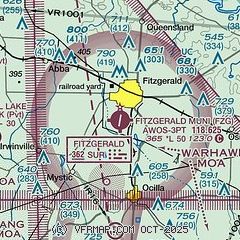
| Sectional chart |
|---|
|
| Airport distance calculator |
|---|
|
|
| Sunrise and sunset |
|---|
|
Times for 10-Sep-2025
| | Local
(UTC-4) | | Zulu
(UTC) |
|---|
| Morning civil twilight | | 06:51 | | 10:51 |
| Sunrise | | 07:15 | | 11:15 |
| Sunset | | 19:45 | | 23:45 |
| Evening civil twilight | | 20:10 | | 00:10 |
|
| Current date and time |
|---|
| Zulu (UTC) | 10-Sep-2025 14:20:58 |
|---|
| Local (UTC-4) | 10-Sep-2025 10:20:58 |
|---|
|
| METAR |
|---|
| KFZG | 101355Z AUTO 04005KT 10SM CLR 22/15 A3015 RMK AO2 T02160148
|
KTMA
19nm SW | 101355Z AUTO 05007KT 10SM CLR 22/14 A3015 RMK AO2 T02190145
|
|
| TAF |
|---|
KVAD
43nm S | 100800Z 1008/1114 03009KT 9999 FEW040 QNH3001INS BECMG 1013/1014 03010G15KT 9999 FEW060 QNH3002INS BECMG 1020/1021 03009KT 9999 SKC QNH3001INS TX30/1020Z TN19/1008Z
|
KABY
48nm W | 101120Z 1012/1112 04007KT P6SM FEW100 FM101500 04010G20KT P6SM SCT070 FM102300 03005KT P6SM SCT070
|
|
| NOTAMs |
|---|
NOTAMs are issued by the DoD/FAA and will open in a separate window not controlled by AirNav.
|
|


