FAA INFORMATION EFFECTIVE 27 NOVEMBER 2025
Location
| FAA Identifier: | DTL |
| Lat/Long: | 46-49-22.9660N 095-52-58.0290W
46-49.382767N 095-52.967150W
46.8230461,-95.8827858
(estimated) |
| Elevation: | 1395.9 ft. / 425.5 m (surveyed) |
| Variation: | 02E (2025) |
| From city: | 2 miles W of DETROIT LAKES, MN |
| Time zone: | UTC -6 (UTC -5 during Daylight Saving Time) |
| Zip code: | 56501 |
Airport Operations
| Airport use: | Open to the public |
| Activation date: | 12/1944 |
| Control tower: | no |
| ARTCC: | MINNEAPOLIS CENTER |
| FSS: | PRINCETON FLIGHT SERVICE STATION |
| NOTAMs facility: | DTL (NOTAM-D service available) |
| Attendance: | MON-FRI 0800-1700 |
| Wind indicator: | lighted |
| Segmented circle: | yes |
| Lights: | ACTVT MALSF RWY 32; REIL RWY 14; HIRL RWY 14/32 - CTAF. PAPI RWY 14 & 32 OPR CONSLY. |
| Beacon: | white-green (lighted land airport)
Operates sunset to sunrise. |
Airport Communications
| CTAF/UNICOM: | 122.8 |
| WX AWOS-3PT: | 119.075 (218-847-8626) |
- COMMUNICATIONS PRVDD BY PRINCETON RADIO ON FREQ 122.5 (DETROIT LAKES RCO).
- APCH/DEP SVC PRVDD BY MINNEAPOLIS ARTCC (ZMP) ON FREQ 126.1/269.2 (ALEXANDRIA RCAG).
Nearby radio navigation aids
| VOR radial/distance | | VOR name | | Freq | | Var |
|---|
| DTL at field | | DETROIT LAKES VOR/DME | | 111.20 | | 02E |
| FFMr014/34.0 | | FERGUS FALLS VOR/DME | | 110.40 | | 05E |
Airport Services
| Fuel available: | 100LL JET-A
100LL:100LL AVBL H24 SELF SVC. FOR JET A SVC AFT HRS CALL AMGR. |
| Parking: | hangars and tiedowns |
| Airframe service: | MAJOR |
| Powerplant service: | MAJOR |
| Bottled oxygen: | NONE |
| Bulk oxygen: | NONE |
Runway Information
Runway 14/32
| Dimensions: | 5201 x 100 ft. / 1585 x 30 m |
| Surface: | asphalt, in good condition |
| Weight bearing capacity: | | Single wheel: | 23.0 | | Double wheel: | 42.0 |
|
| Runway edge lights: | high intensity |
| RUNWAY 14 | | RUNWAY 32 |
| Latitude: | 46-49.648807N | | 46-48.994522N |
| Longitude: | 095-53.223863W | | 095-52.420942W |
| Elevation: | 1392.8 ft. | | 1362.0 ft. |
| Traffic pattern: | left | | left |
| Runway heading: | 138 magnetic, 140 true | | 318 magnetic, 320 true |
| Markings: | precision, in good condition | | precision, in good condition |
| Visual slope indicator: | 4-light PAPI on left (3.00 degrees glide path) | | 4-light PAPI on left (3.00 degrees glide path) |
| Approach lights: | | | MALSF: 1,400 foot medium intensity approach lighting system with sequenced flashers |
| Runway end identifier lights: | yes | | no |
| Touchdown point: | yes, no lights | | yes, no lights |
Runway 18/36
| Dimensions: | 1890 x 250 ft. / 576 x 76 m |
| Surface: | turf, in fair condition |
| Runway edge markings: | CONES. |
| Operational restrictions: | NOT PLOWED WINTER MONTHS. |
| RUNWAY 18 | | RUNWAY 36 |
| Latitude: | 46-49.706330N | | 46-49.395513N |
| Longitude: | 095-53.364885W | | 095-53.366528W |
| Elevation: | 1395.9 ft. | | 1373.0 ft. |
| Traffic pattern: | left | | left |
| Runway heading: | 178 magnetic, 180 true | | 358 magnetic, 000 true |
| Runway end identifier lights: | no | | no |
| Touchdown point: | yes, no lights | | yes, no lights |
| Obstructions: | none | | 45 ft. trees, 618 ft. from runway, 176 ft. left of centerline, 13:1 slope to clear |
Airport Ownership and Management from official FAA records
| Ownership: | Publicly-owned |
| Owner: | CITY OF DETROIT LAKES
1025 ROOSEVELT AVE, PO BOX 647
DETROIT LAKES, MN 56501
Phone 218-847-5658
OWNED ALSO BY BECKER COUNTY. |
| Manager: | ERIK CARLSON
1817 US HWY 10 W
DETROIT LAKES, MN 56501-7979
Phone 218-841-8233 |
Additional Remarks
| - | FOR CD IF UNA TO CTC ON FSS FREQ, CTC MINNEAPOLIS ARTCC AT 651-463-5588. |
Instrument Procedures
NOTE: All procedures below are presented as PDF files. If you need a reader for these files, you should download the free Adobe Reader.NOT FOR NAVIGATION. Please procure official charts for flight.
FAA instrument procedures published for use from 27 November 2025 at 0901Z to 25 December 2025 at 0900Z.
IAPs - Instrument Approach Procedures |
|---|
| RNAV (GPS) RWY 14 | |
download (234KB) |
| RNAV (GPS) RWY 32 | |
download (227KB) |
| VOR RWY 32 | |
download (277KB) |
| NOTE: Special Alternate Minimums apply | |
download (151KB) |
| NOTE: Special Take-Off Minimums/Departure Procedures apply | |
download (404KB) |
Other nearby airports with instrument procedures:
16D - Perham Municipal Airport (17 nm SE)
04Y - Hawley Municipal Airport (20 nm W)
3N8 - Mahnomen County Airport (26 nm N)
KJKJ - Moorhead Municipal Airport/Florence Klingensmith Field (32 nm W)
KPKD - Park Rapids Municipal Airport-Konshok Field (34 nm E)
|
|

Road maps at:
MapQuest
Bing
Google
| Aerial photo |
|---|
WARNING: Photo may not be current or correct
 Photo taken 28-Jul-2005
Do you have a better or more recent aerial photo of Detroit Lakes Airport-Wething Field that you would like to share? If so, please send us your photo.
|
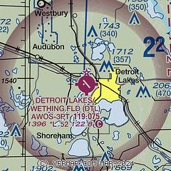
| Sectional chart |
|---|
|
| Airport distance calculator |
|---|
|
|
| Sunrise and sunset |
|---|
|
Times for 07-Dec-2025
| | Local
(UTC-6) | | Zulu
(UTC) |
|---|
| Morning civil twilight | | 07:21 | | 13:21 |
| Sunrise | | 07:56 | | 13:56 |
| Sunset | | 16:34 | | 22:34 |
| Evening civil twilight | | 17:09 | | 23:09 |
|
| Current date and time |
|---|
| Zulu (UTC) | 08-Dec-2025 04:29:35 |
|---|
| Local (UTC-6) | 07-Dec-2025 22:29:35 |
|---|
|
| METAR |
|---|
| KDTL | 080415Z AUTO 14008KT 10SM FEW034 BKN047 OVC060 M15/M20 A3022 RMK AO2 T11511195
|
|
| TAF |
|---|
KFAR
39nm W | 080207Z 0802/0824 00000KT P6SM OVC070 PROB30 0802/0805 4SM -SN OVC035 FM080500 17010KT P6SM BKN025 FM082200 20012G20KT P6SM BKN010
|
|
| NOTAMs |
|---|
NOTAMs are issued by the DoD/FAA and will open in a separate window not controlled by AirNav.
|
|

