FAA INFORMATION EFFECTIVE 16 APRIL 2026
Location
| FAA Identifier: | DVP |
| Lat/Long: | 43-59-12.4810N 095-46-57.3970W
43-59.208017N 095-46.956617W
43.9868003,-95.7826103
(estimated) |
| Elevation: | 1623 ft. / 495 m (estimated) |
| Variation: | 04E (2000) |
| From city: | 1 mile W of SLAYTON, MN |
| Time zone: | UTC -5 (UTC -6 during Standard Time) |
| Zip code: | 56172 |
Airport Operations
| Airport use: | Open to the public |
| Control tower: | no |
| ARTCC: | MINNEAPOLIS CENTER |
| FSS: | PRINCETON FLIGHT SERVICE STATION |
| NOTAMs facility: | DVP (NOTAM-D service available) |
| Attendance: | UNATNDD
FOR SVC CALL 507-836-6460. |
| Wind indicator: | lighted |
| Segmented circle: | no |
| Lights: | ACTVT REIL RWY 17 & 35; PAPI RWY 17 & 35; MIRL RWY 17/35 - CTAF. |
| Beacon: | white-green (lighted land airport)
Operates sunset to sunrise. |
Airport Communications
| CTAF: | 122.9 |
| WX AWOS-3: | 118.55 (507-836-6128) |
| WX AWOS-3PT at TKC (17 nm NE): | 120.0 (507-629-9006) |
- APCH/DEP SVC PRVDD BY MINNEAPOLIS ARTCC ON FREQS 132.05/317.4 (SIOUX FALLS RCAG).
Nearby radio navigation aids
| VOR radial/distance | | VOR name | | Freq | | Var |
|---|
| MMLr171/27.8 | | MARSHALL VOR/DME | | 111.00 | | 05E |
Airport Services
| Fuel available: | 100LL |
| Parking: | tiedowns |
| Airframe service: | NONE |
| Powerplant service: | NONE |
| Bottled oxygen: | NONE |
| Bulk oxygen: | NONE |
Runway Information
Runway 17/35
| Dimensions: | 3005 x 60 ft. / 916 x 18 m |
| Surface: | asphalt, in good condition |
| Runway edge lights: | medium intensity |
| RUNWAY 17 | | RUNWAY 35 |
| Latitude: | 43-59.455300N | | 43-58.960717N |
| Longitude: | 095-46.956617W | | 095-46.956617W |
| Elevation: | 1614.7 ft. | | 1622.9 ft. |
| Traffic pattern: | left | | left |
| Runway heading: | 176 magnetic, 180 true | | 356 magnetic, 000 true |
| Markings: | nonprecision, in good condition | | nonprecision, in good condition |
| Visual slope indicator: | 2-light PAPI on left (3.00 degrees glide path) | | 2-light PAPI on left (3.00 degrees glide path) |
| Runway end identifier lights: | yes | | yes |
| Touchdown point: | yes, no lights | | yes, no lights |
| Obstructions: | 15 ft. road, 201 ft. from runway, 235 ft. right of centerline
+15 FT ROAD, 0-200 FT DIST, 235 FT R. | | 15 ft. road, 201 ft. from runway, 235 ft. left of centerline
+15 FT ROAD, 0-200 FT DIST, 235 FT L. |
Airport Ownership and Management from official FAA records
| Ownership: | Publicly-owned |
| Owner: | CITY OF SLAYTON
2424 26TH ST
SLAYTON, MN 56172-1244
Phone 507-836-8534 |
| Manager: | JOSH MALCHOW
2424 26TH ST
SLAYTON, MN 56172-1244
Phone 507-836-8534 |
Additional Remarks
| - | FOR CD CTC MINNEAPOLIS ARTCC AT 651-463-5588. |
Instrument Procedures
NOTE: All procedures below are presented as PDF files. If you need a reader for these files, you should download the free Adobe Reader.NOT FOR NAVIGATION. Please procure official charts for flight.
FAA instrument procedures published for use from 16 April 2026 at 0901Z to 14 May 2026 at 0900Z.
IAPs - Instrument Approach Procedures |
|---|
| RNAV (GPS) RWY 17 **CHANGED** | |
download (183KB) |
| RNAV (GPS) RWY 35 **CHANGED** | |
download (175KB) |
| NOTE: Special Alternate Minimums apply | |
download (46KB) |
| NOTE: Special Take-Off Minimums/Departure Procedures apply | |
download (156KB) |
Other nearby airports with instrument procedures:
KTKC - Tracy Municipal Airport (17 nm NE)
KOTG - Worthington Municipal Airport (22 nm SE)
KPQN - Pipestone Municipal Airport (22 nm W)
KMML - Southwest Minnesota Regional Airport - Marshall/Ryan Field (28 nm N)
KLYV - Quentin Aanenson Field Airport (29 nm SW)
|
|

Road maps at:
MapQuest
Bing
Google
| Aerial photo |
|---|

|
| Sectional chart |
|---|
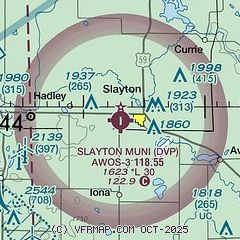
|
| Airport distance calculator |
|---|
|
|
| Sunrise and sunset |
|---|
|
Times for 21-Apr-2026
| | Local
(UTC-5) | | Zulu
(UTC) |
|---|
| Morning civil twilight | | 06:00 | | 11:00 |
| Sunrise | | 06:31 | | 11:31 |
| Sunset | | 20:13 | | 01:13 |
| Evening civil twilight | | 20:43 | | 01:43 |
|
| Current date and time |
|---|
| Zulu (UTC) | 21-Apr-2026 20:04:00 |
|---|
| Local (UTC-5) | 21-Apr-2026 15:04:00 |
|---|
|
| METAR |
|---|
| KDVP | 211953Z AUTO 34009KT 10SM CLR 25/00 A2990 RMK AO2 T02540003
|
KTKC
17nm NE | 211955Z AUTO VRB06G12KT 10SM CLR 24/02 A2988 RMK AO2
|
|
| TAF |
|---|
KRWF
45nm NE | 211739Z 2118/2218 36008KT P6SM SKC FM220300 13006KT P6SM SKC FM221300 14010G20KT P6SM FEW250
|
KFSD
48nm SW | 211720Z 2118/2218 36006KT P6SM SKC FM212200 04006KT P6SM FEW250 FM220100 12008KT P6SM FEW250 FM221400 16012G20KT P6SM FEW250 FM221600 18018G26KT P6SM FEW250
|
|
| NOTAMs |
|---|
NOTAMs are issued by the DoD/FAA and will open in a separate window not controlled by AirNav.
|
|

