FAA INFORMATION EFFECTIVE 16 APRIL 2026
Location
| FAA Identifier: | PQN |
| Lat/Long: | 43-58-55.6920N 096-18-01.4670W
43-58.928200N 096-18.024450W
43.9821367,-96.3004075
(estimated) |
| Elevation: | 1736.7 ft. / 529.3 m (surveyed) |
| Variation: | 03E (2015) |
| From city: | 1 mile SE of PIPESTONE, MN |
| Time zone: | UTC -5 (UTC -6 during Standard Time) |
| Zip code: | 56164 |
Airport Operations
| Airport use: | Open to the public |
| Activation date: | 09/1945 |
| Control tower: | no |
| ARTCC: | MINNEAPOLIS CENTER |
| FSS: | PRINCETON FLIGHT SERVICE STATION |
| NOTAMs facility: | PQN (NOTAM-D service available) |
| Attendance: | MON-FRI 0800-1700 |
| Wind indicator: | lighted |
| Segmented circle: | no |
| Lights: | ACTVT REIL RWY 18 & 36; PAPI RWY 18 & 36; MIRL RWY 18/36 - CTAF. |
| Beacon: | white-green (lighted land airport)
Operates sunset to sunrise. |
Airport Communications
| CTAF/UNICOM: | 122.8 |
| WX AWOS-3PT: | 118.375 (507-825-6895) |
- APCH/DEP SVC PRVDD BY MINNEAPOLIS ARTCC ON FREQS 132.050/317.4 (SIOUX FALLS RCAG).
Nearby radio navigation aids
| VOR radial/distance | | VOR name | | Freq | | Var |
|---|
| FSDr037/28.8 | | SIOUX FALLS VORTAC | | 115.00 | | 09E |
| MMLr211/34.7 | | MARSHALL VOR/DME | | 111.00 | | 05E |
Airport Services
| Fuel available: | 100LL JET-A
100LL:FUEL AVBL H24 VIA CREDIT CARD. |
| Parking: | hangars and tiedowns |
| Airframe service: | NONE |
| Powerplant service: | NONE |
| Bottled oxygen: | NONE |
| Bulk oxygen: | NONE |
Runway Information
Runway 18/36
| Dimensions: | 4306 x 75 ft. / 1312 x 23 m |
| Surface: | asphalt, in good condition |
| Weight bearing capacity: | | Single wheel: | 16.0 | | Double wheel: | 22.0 |
|
| Runway edge lights: | medium intensity |
| RUNWAY 18 | | RUNWAY 36 |
| Latitude: | 43-59.214250N | | 43-58.507000N |
| Longitude: | 096-17.974780W | | 096-18.037717W |
| Elevation: | 1736.0 ft. | | 1727.8 ft. |
| Traffic pattern: | left | | left |
| Runway heading: | 181 magnetic, 184 true | | 001 magnetic, 004 true |
| Markings: | nonprecision, in good condition | | nonprecision, in good condition |
| Visual slope indicator: | 4-light PAPI on left (3.00 degrees glide path) | | 4-light PAPI on left (3.00 degrees glide path) |
| Runway end identifier lights: | yes | | yes |
| Touchdown point: | yes, no lights | | yes, no lights |
| Obstructions: | 13 ft. brush, 412 ft. from runway, 145 ft. right of centerline, 16:1 slope to clear | | none |
Runway 9/27
| Dimensions: | 2539 x 196 ft. / 774 x 60 m |
| Surface: | turf, in good condition |
| Runway edge markings: | YELLOW CONES. |
| Operational restrictions: | NOT PLOWED WINTER MONTHS. |
| RUNWAY 9 | | RUNWAY 27 |
| Latitude: | 43-59.067000N | | 43-59.018500N |
| Longitude: | 096-18.342833W | | 096-17.767800W |
| Elevation: | 1723.7 ft. | | 1736.6 ft. |
| Traffic pattern: | left | | left |
| Runway heading: | 094 magnetic, 097 true | | 274 magnetic, 277 true |
| Touchdown point: | yes, no lights | | yes, no lights |
| Obstructions: | none | | 10 ft. crops, 22 ft. from runway, 2:1 slope to clear |
Airport Ownership and Management from official FAA records
| Ownership: | Publicly-owned |
| Owner: | CITY OF PIPESTONE
119 2ND AVE SW
PIPESTONE, MN 56164-1683
Phone 507-562-2332 |
| Manager: | ROBERT DYKSTRA
1302 13TH ST SE
PIPESTONE, MN 56164-2294
Phone 605-360-2233
RDYKS@AOL.COM. |
Additional Remarks
| - | GCO AVBL ON FREQ 121.725 THRU MINNEAPOLIS ARTCC & FLT SVCS. |
| - | FOR CD IF UNA VIA GCO CTC MINNEAPOLIS ARTCC AT 651-463-5588. |
Instrument Procedures
NOTE: All procedures below are presented as PDF files. If you need a reader for these files, you should download the free Adobe Reader.NOT FOR NAVIGATION. Please procure official charts for flight.
FAA instrument procedures published for use from 16 April 2026 at 0901Z to 14 May 2026 at 0900Z.
IAPs - Instrument Approach Procedures |
|---|
| RNAV (GPS) RWY 18 | |
download (274KB) |
| RNAV (GPS) RWY 36 | |
download (224KB) |
| NOTE: Special Alternate Minimums apply | |
download (28KB) |
| NOTE: Special Take-Off Minimums/Departure Procedures apply | |
download (156KB) |
Other nearby airports with instrument procedures:
KLYV - Quentin Aanenson Field Airport (22 nm S)
KDVP - Slayton Municipal Airport (22 nm E)
KBKX - Brookings Regional Airport (30 nm NW)
KFSD - Joe Foss Field Airport (31 nm SW)
KRRQ - Rock Rapids Municipal Airport (32 nm S)
|
|

Road maps at:
MapQuest
Bing
Google
| Aerial photo |
|---|
WARNING: Photo may not be current or correct

Do you have a better or more recent aerial photo of Pipestone Municipal Airport that you would like to share? If so, please send us your photo.
|
| Sectional chart |
|---|
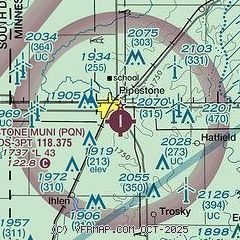
|
| Airport distance calculator |
|---|
|
|
| Sunrise and sunset |
|---|
|
Times for 02-May-2026
| | Local
(UTC-5) | | Zulu
(UTC) |
|---|
| Morning civil twilight | | 05:45 | | 10:45 |
| Sunrise | | 06:16 | | 11:16 |
| Sunset | | 20:28 | | 01:28 |
| Evening civil twilight | | 21:00 | | 02:00 |
|
| Current date and time |
|---|
| Zulu (UTC) | 02-May-2026 11:21:54 |
|---|
| Local (UTC-5) | 02-May-2026 06:21:54 |
|---|
|
| METAR |
|---|
| KPQN | 021055Z AUTO 22003KT 10SM CLR M01/M01 A3011 RMK AO2 T10091009
|
|
| TAF |
|---|
KFSD
31nm SW | 020520Z 0206/0306 VRB03KT P6SM SKC FM021400 24007KT P6SM FEW120 FEW250 FM022000 23012G18KT P6SM SCT120 FM030100 22008KT P6SM BKN100
|
|
| NOTAMs |
|---|
NOTAMs are issued by the DoD/FAA and will open in a separate window not controlled by AirNav.
|
|

