FAA INFORMATION EFFECTIVE 11 JUNE 2026
Location
| FAA Identifier: | DYB |
| Lat/Long: | 33-03-44.2000N 080-16-51.3000W
33-03.736667N 080-16.855000W
33.0622778,-80.2809167
(estimated) |
| Elevation: | 55.8 ft. / 17.0 m (surveyed) |
| Variation: | 07W (2010) |
| From city: | 5 miles NW of SUMMERVILLE, SC |
| Time zone: | UTC -4 (UTC -5 during Standard Time) |
| Zip code: | 29483 |
Airport Operations
| Airport use: | Open to the public |
| Activation date: | 10/1986 |
| Control tower: | no |
| ARTCC: | JACKSONVILLE CENTER |
| FSS: | ANDERSON FLIGHT SERVICE STATION |
| NOTAMs facility: | AND (NOTAM-D service available) |
| Attendance: | MON - FRI 0800 - 1800, ALL SAT - SUN 0830 - 1700 |
| Wind indicator: | lighted |
| Segmented circle: | yes |
| Lights: | MIRL RWY 06/24 OPER DUSK-2200; TO ACTVT AFTER 2200 - CTAF. |
| Beacon: | white-green (lighted land airport)
Operates sunset to sunrise. |
Airport Communications
| CTAF/UNICOM: | 123.0 |
| WX AWOS-3: | 119.575 (843-821-8403) |
| CHARLESTON APPROACH: | 120.7 |
| CHARLESTON DEPARTURE: | 120.7 |
| WX AWOS-3 at MKS (14 nm NE): | 119.175 (843-761-1486) |
| WX ASOS at CHS (16 nm SE): | PHONE 843-214-2525 |
| WX AWOS-3PT at RBW (20 nm SW): | 118.725 (843-538-3575) |
Nearby radio navigation aids
| VOR radial/distance | | VOR name | | Freq | | Var |
|---|
| CHSr314/15.9 | | CHARLESTON VORTAC | | 113.50 | | 05W |
Airport Services
| Fuel available: | 100LL JET-A+ |
| Parking: | tiedowns |
| Airframe service: | MAJOR |
| Powerplant service: | MAJOR |
Runway Information
Runway 6/24
| Dimensions: | 5000 x 75 ft. / 1524 x 23 m |
| Surface: | asphalt, in good condition |
| Weight bearing capacity: | | PCN 7 /F/C/X/T | | Single wheel: | 19.5 | | Double wheel: | 31.0 |
|
| Runway edge lights: | medium intensity |
| RUNWAY 6 | | RUNWAY 24 |
| Latitude: | 33-03.465793N | | 33-04.005983N |
| Longitude: | 080-17.225432W | | 080-16.485738W |
| Elevation: | 38.4 ft. | | 53.5 ft. |
| Traffic pattern: | right | | left |
| Runway heading: | 056 magnetic, 049 true | | 236 magnetic, 229 true |
| Markings: | nonprecision, in good condition | | nonprecision, in good condition |
| Touchdown point: | yes, no lights | | yes, no lights |
| Obstructions: | trees, 34:1 slope to clear | | 75 ft. tree, 1560 ft. from runway, 221 ft. right of centerline, 18:1 slope to clear |
Airport Ownership and Management from official FAA records
| Ownership: | Publicly-owned |
| Owner: | DORCHESTER COUNTY
BOX 416
ST. GEORGE, SC 29477
Phone 843-806-1180 |
| Manager: | JEFFREY CRAVEN
898 GREYBACK RD, P.O. BOX 3
SUMMERVILLE, SC 29483
Phone 843-867-3927 |
Additional Remarks
| - | FOR FBO CALL (843) 806-1180. |
| - | BANNER TOWING 1500/BLO INTMT DAILY, SOUTH SIDE RWY 06/24. |
| - | FOR CD CTC CHARLESTON APCH AT 843-414-2832. |
| - | MOWING OPS ON WEDS NEAR ACTV RWYS/TWYS DURG GROWING SEASON. |
| - | VISIT DORCHESTERCOUNTYSC.GOV/GOVERNMENT/ADMINISTRATIVE-SERVICES/AIRPORT FOR AIRFIELD STS AND OTHER ARPT INFO. |
| - | CURRENT AWOS INFO - KDYB.AWOSNET.COM |
Instrument Procedures
NOTE: All procedures below are presented as PDF files. If you need a reader for these files, you should download the free Adobe Reader.NOT FOR NAVIGATION. Please procure official charts for flight.
FAA instrument procedures published for use from 11 June 2026 at 0901Z to 09 July 2026 at 0900z.
IAPs - Instrument Approach Procedures |
|---|
| RNAV (GPS) RWY 06 | |
download (186KB) |
| RNAV (GPS) RWY 24 | |
download (192KB) |
| NOTE: Special Alternate Minimums apply | |
download (21KB) |
| NOTE: Special Take-Off Minimums/Departure Procedures apply | |
download (238KB) |
Other nearby airports with instrument procedures:
6J2 - St George Airport (14 nm NW)
KMKS - Berkeley County Airport (14 nm NE)
KCHS - Charleston Air Force Base/International Airport (16 nm SE)
KRBW - Lowcountry Regional Airport (20 nm SW)
KJZI - Charleston Executive Airport (26 nm SE)
|
|

Road maps at:
MapQuest
Bing
Google
| Aerial photo |
|---|
WARNING: Photo may not be current or correct
 Photo courtesy of AirNav, LLC
Photo taken 03-Jul-2010
Photo courtesy of AirNav, LLC
Photo taken 03-Jul-2010
Do you have a better or more recent aerial photo of Summerville Airport that you would like to share? If so, please send us your photo.
|
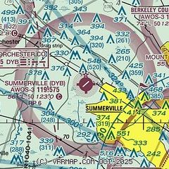
| Sectional chart |
|---|
|
| Airport distance calculator |
|---|
|
|
| Sunrise and sunset |
|---|
|
Times for 21-Jun-2026
| | Local
(UTC-4) | | Zulu
(UTC) |
|---|
| Morning civil twilight | | 05:45 | | 09:45 |
| Sunrise | | 06:14 | | 10:14 |
| Sunset | | 20:32 | | 00:32 |
| Evening civil twilight | | 21:01 | | 01:01 |
|
| Current date and time |
|---|
| Zulu (UTC) | 21-Jun-2026 09:04:26 |
|---|
| Local (UTC-4) | 21-Jun-2026 05:04:26 |
|---|
|
| METAR |
|---|
| KDYB | 210835Z AUTO 00000KT 1 3/4SM BR OVC002 22/22 A2991 RMK AO2
|
KMKS
14nm NE | 210835Z AUTO 00000KT 10SM CLR 20/20 A2993 RMK AO2
|
KCHS
16nm SE | 210856Z 24003KT 10SM BKN200 23/22 A2992 RMK AO2 SLP131 T02330222 56007
|
KRBW
20nm SW | 210855Z AUTO 00000KT 10SM OVC002 22/22 A2994 RMK AO2
|
|
| TAF |
|---|
KCHS
16nm SE | 210522Z 2106/2206 00000KT P6SM SCT250 FM211300 26005KT P6SM SCT250 FM211600 22006KT P6SM SCT050 PROB30 2117/2120 4SM -TSRA BR BKN050CB FM212000 18010KT P6SM FEW050 FM220200 23005KT P6SM SCT250
|
|
| NOTAMs |
|---|
NOTAMs are issued by the DoD/FAA and will open in a separate window not controlled by AirNav.
|
|


