FAA INFORMATION EFFECTIVE 09 JULY 2026
Location
| FAA Identifier: | MKS |
| Lat/Long: | 33-11-05.4130N 080-02-13.1150W
33-11.090217N 080-02.218583W
33.1848369,-80.0369764
(estimated) |
| Elevation: | 74 ft. / 22.6 m (surveyed) |
| Variation: | 07W (2010) |
| From city: | 1 mile SW of MONCKS CORNER, SC |
| Time zone: | UTC -4 (UTC -5 during Standard Time) |
| Zip code: | 29461 |
Airport Operations
| Airport use: | Open to the public |
| Activation date: | 10/1947 |
| Control tower: | no |
| ARTCC: | JACKSONVILLE CENTER |
| FSS: | ANDERSON FLIGHT SERVICE STATION |
| NOTAMs facility: | AND (NOTAM-D service available) |
| Attendance: | FRI-SAT 0800-1800, ALL SUN-THUR 0800-1800 |
| Wind indicator: | lighted |
| Segmented circle: | yes |
| Lights: | ACTVT MIRL RWY 05/23 - CTAF. |
| Beacon: | white-green (lighted land airport)
Operates sunset to sunrise. |
Airport Communications
| CTAF/UNICOM: | 123.05 |
| WX AWOS-3: | 119.175 (843-761-1486) |
| CHARLESTON APPROACH: | 121.275 |
| CHARLESTON DEPARTURE: | 121.275 |
| WX AWOS-3PT at DYB (14 nm SW): | 119.575 (843-851-5786) |
| WX ASOS at CHS (17 nm S): | PHONE 843-214-2525 |
Nearby radio navigation aids
| VOR radial/distance | | VOR name | | Freq | | Var |
|---|
| CHSr005/17.4 | | CHARLESTON VORTAC | | 113.50 | | 05W |
Airport Services
| Fuel available: | 100LL JET-A |
| Parking: | hangars and tiedowns |
| Airframe service: | MAJOR |
| Powerplant service: | MAJOR |
| Bottled oxygen: | NONE |
| Bulk oxygen: | NONE |
Runway Information
Runway 5/23
| Dimensions: | 5001 x 75 ft. / 1524 x 23 m |
| Surface: | concrete, in excellent condition |
| Weight bearing capacity: | | PCN 20 /R/B/X/T | | Single wheel: | 35.0 | | Double wheel: | 52.0 |
|
| Runway edge lights: | medium intensity |
| RUNWAY 5 | | RUNWAY 23 |
| Latitude: | 33-10.787823N | | 33-11.392595N |
| Longitude: | 080-02.551933W | | 080-01.885183W |
| Elevation: | 74.0 ft. | | 69.1 ft. |
| Traffic pattern: | left | | left |
| Runway heading: | 050 magnetic, 043 true | | 230 magnetic, 223 true |
| Displaced threshold: | 650 ft. | | no |
| Markings: | nonprecision, in good condition | | nonprecision, in good condition |
| Visual slope indicator: | | | 2-light PAPI on left (3.00 degrees glide path) |
| Touchdown point: | yes, no lights | | yes, no lights |
| Obstructions: | 42 ft. tree, 625 ft. from runway, 34 ft. right of centerline, 10:1 slope to clear | | 97 ft. tree, 1898 ft. from runway, 500 ft. right of centerline, 17:1 slope to clear |
Airport Ownership and Management from official FAA records
| Ownership: | Publicly-owned |
| Owner: | COUNTY OF BERKELEY
P.O. BOX 6122
MONCKS CORNER, SC 29461
Phone 843-899-7711 |
| Manager: | STACY THOMAS
616 WHITESVILLE ROAD
MONCKS CORNER, SC 29461
Phone (843) 719-4751 |
Additional Remarks
| - | CTN: MIL AND CHS TFC IN VCNTY. |
| - | WILDLIFE ON AND INVOF ARPT WITH INCR ACT AT DUSK AND DAWN. |
| - | FOR CD CTC CHARLESTON APCH AT 843-414-2832. |
Instrument Procedures
NOTE: All procedures below are presented as PDF files. If you need a reader for these files, you should download the free Adobe Reader.NOT FOR NAVIGATION. Please procure official charts for flight.
FAA instrument procedures published for use from 09 July 2026 at 0901Z to 06 August 2026 at 0900Z.
IAPs - Instrument Approach Procedures |
|---|
| RNAV (GPS) RWY 05 | |
download (261KB) |
| RNAV (GPS) RWY 23 | |
download (262KB) |
| VOR/DME-A | |
download (193KB) |
| NOTE: Special Alternate Minimums apply | |
download (167KB) |
| NOTE: Special Take-Off Minimums/Departure Procedures apply | |
download (141KB) |
Other nearby airports with instrument procedures:
KDYB - Summerville Airport (14 nm SW)
KCHS - Charleston Air Force Base/International Airport (17 nm S)
KLRO - Mount Pleasant Regional Airport-Faison Field (21 nm SE)
6J2 - St George Airport (24 nm W)
KMNI - Santee Cooper Regional Airport (26 nm N)
|
|

Road maps at:
MapQuest
Bing
Google
| Aerial photo |
|---|
WARNING: Photo may not be current or correct
 Taken in October 2005
Do you have a better or more recent aerial photo of Berkeley County Airport that you would like to share? If so, please send us your photo.
|
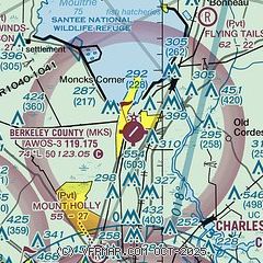
| Sectional chart |
|---|
|
CAUTION: Diagram may not be current

| Airport distance calculator |
|---|
|
|
| Sunrise and sunset |
|---|
|
Times for 01-Aug-2026
| | Local
(UTC-4) | | Zulu
(UTC) |
|---|
| Morning civil twilight | | 06:07 | | 10:07 |
| Sunrise | | 06:34 | | 10:34 |
| Sunset | | 20:19 | | 00:19 |
| Evening civil twilight | | 20:46 | | 00:46 |
|
| Current date and time |
|---|
| Zulu (UTC) | 01-Aug-2026 05:25:20 |
|---|
| Local (UTC-4) | 01-Aug-2026 01:25:20 |
|---|
|
| METAR |
|---|
| KMKS | 010455Z AUTO 00000KT 10SM CLR 26/23 A2996 RMK AO2
|
KDYB
14nm SW | 010455Z AUTO 00000KT 9SM CLR 27/24 A2994 RMK AO2
|
KCHS
17nm S | 010456Z 16013G17KT 10SM BKN024 BKN100 28/24 A2996 RMK AO2 SLP143 T02830244 403330233
|
|
| TAF |
|---|
KCHS
17nm S | 312219Z 3122/0118 15012KT P6SM SCT035 SCT070 FM010300 14003KT P6SM FEW020 SCT200 FM011500 14008G15KT P6SM SCT110
|
|
| NOTAMs |
|---|
NOTAMs are issued by the DoD/FAA and will open in a separate window not controlled by AirNav.
|
|


