FAA INFORMATION EFFECTIVE 09 JULY 2026
Location
| FAA Identifier: | MNI |
| Lat/Long: | 33-35-13.5620N 080-12-31.2120W
33-35.226033N 080-12.520200W
33.5871006,-80.2086700
(estimated) |
| Elevation: | 102.7 ft. / 31.3 m (surveyed) |
| Variation: | 06W (1995) |
| From city: | 7 miles S of MANNING, SC |
| Time zone: | UTC -4 (UTC -5 during Standard Time) |
| Zip code: | 29102 |
Airport Operations
| Airport use: | Open to the public |
| Activation date: | 09/1966 |
| Control tower: | no |
| ARTCC: | JACKSONVILLE CENTER |
| FSS: | ANDERSON FLIGHT SERVICE STATION |
| NOTAMs facility: | AND (NOTAM-D service available) |
| Attendance: | MON-FRI 0800-1700 |
| Wind indicator: | lighted |
| Segmented circle: | yes |
| Lights: | MIRL PRESET LOW INTST DUSK-2300; TO INCR INTST - CTAF. TO ACTVT AFT 2300 - CTAF. |
| Beacon: | white-green (lighted land airport)
Operates sunset to sunrise. |
Airport Communications
| CTAF/UNICOM: | 122.8 |
| WX AWOS-3: | 120.175 (803-478-6060) |
| SHAW APPROACH: | 125.4 |
| SHAW DEPARTURE: | 125.4 |
| WX AWOS-3 at CKI (19 nm NE): | 124.775 (843-382-3000) |
- APCH/DEP SVC PRVDD BY JACKSONVILLE ARTCC ON FREQS 124.7/269.55 (COLUMBIA RCAG) WHEN SHAW APCH CTL CLSD.
Nearby radio navigation aids
| VOR radial/distance | | VOR name | | Freq | | Var |
|---|
| MMTr132/35.9 | | MC ENTIRE VORTAC | | 113.20 | | 08W |
| NDB name | | Hdg/Dist | | Freq | | Var | | ID |
|---|
| MANNING | | at field | | 381 | | 06W | | MNI | -- -. .. |
| EVANS | | 240/27.3 | | 420 | | 06W | | CFY | -.-. ..-. -.-- |
| DORCHESTER COUNTY | | 013/31.7 | | 365 | | 07W | | DYB | -.. -.-- -... |
Airport Services
| Fuel available: | 100LL JET-A
100LL:SELF SVC 100LL AVBL 24 HRS WITH CREDIT CARD.
A:SELF SVC JET-A AVBL 24 HRS WITH CREDIT CARD. |
| Parking: | tiedowns |
| Airframe service: | MAJOR |
| Powerplant service: | MINOR |
| Bottled oxygen: | NONE |
| Bulk oxygen: | NONE |
Runway Information
Runway 2/20
| Dimensions: | 3602 x 75 ft. / 1098 x 23 m |
| Surface: | asphalt, in good condition |
| Weight bearing capacity: | |
| Runway edge lights: | medium intensity |
| RUNWAY 2 | | RUNWAY 20 |
| Latitude: | 33-34.935730N | | 33-35.516347N |
| Longitude: | 080-12.594948W | | 080-12.445440W |
| Elevation: | 94.4 ft. | | 102.7 ft. |
| Traffic pattern: | left | | left |
| Runway heading: | 018 magnetic, 012 true | | 198 magnetic, 192 true |
| Markings: | nonprecision, in good condition | | nonprecision, in good condition |
| Visual slope indicator: | 2-light PAPI on left (4.00 degrees glide path) | | 2-light PAPI on left (4.00 degrees glide path) |
| Runway end identifier lights: | no | | no |
| Touchdown point: | yes, no lights | | yes, no lights |
| Obstructions: | 50 ft. tree, 1153 ft. from runway, 230 ft. right of centerline, 19:1 slope to clear | | 58 ft. tree, 1471 ft. from runway, 93 ft. right of centerline, 21:1 slope to clear |
Airport Ownership and Management from official FAA records
| Ownership: | Publicly-owned |
| Owner: | CLARENDON COUNTY
PO BOX 486
MANNING, SC 29102
Phone 803-435-8424 |
| Manager: | MS. VICKIE WILLIAMS
8606 HIGHWAY 260
MANNING, SC 29102
Phone 803-433-4004 |
Additional Remarks
| - | GLIDER OPNS ON & INVOF ARPT. |
| - | FOR CD CTC SHAW APCH AT 803-895-4884, WHEN APCH CLSD CTC JACKSONVILLE ARTCC AT 904-845-1592. |
Instrument Procedures
NOTE: All procedures below are presented as PDF files. If you need a reader for these files, you should download the free Adobe Reader.NOT FOR NAVIGATION. Please procure official charts for flight.
FAA instrument procedures published for use from 09 July 2026 at 0901Z to 06 August 2026 at 0900Z.
IAPs - Instrument Approach Procedures |
|---|
| RNAV (GPS) RWY 20 **CHANGED** | |
download (205KB) |
| NOTE: Special Alternate Minimums apply | |
download (168KB) |
| NOTE: Special Take-Off Minimums/Departure Procedures apply | |
download (392KB) |
Other nearby airports with instrument procedures:
KCKI - Williamsburg Regional Airport (19 nm NE)
KMKS - Berkeley County Airport (26 nm S)
KSMS - Sumter Airport (26 nm N)
KSSC - Shaw Air Force Base (27 nm NW)
51J - Lake City Municipal Airport-CJ Evans Field (27 nm NE)
|
|

Road maps at:
MapQuest
Bing
Google
| Aerial photo |
|---|
WARNING: Photo may not be current or correct

Do you have a better or more recent aerial photo of Santee Cooper Regional Airport that you would like to share? If so, please send us your photo.
|
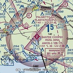
| Sectional chart |
|---|
|
| Airport distance calculator |
|---|
|
|
| Sunrise and sunset |
|---|
|
Times for 13-Jul-2026
| | Local
(UTC-4) | | Zulu
(UTC) |
|---|
| Morning civil twilight | | 05:53 | | 09:53 |
| Sunrise | | 06:21 | | 10:21 |
| Sunset | | 20:32 | | 00:32 |
| Evening civil twilight | | 21:00 | | 01:00 |
|
| Current date and time |
|---|
| Zulu (UTC) | 13-Jul-2026 23:12:40 |
|---|
| Local (UTC-4) | 13-Jul-2026 19:12:40 |
|---|
|
| METAR |
|---|
| KMNI | 132235Z AUTO 14004KT 10SM SCT110 24/22 A3005 RMK AO2 LTG DSNT SE
|
KCKI
19nm NE | 132235Z AUTO 13009G17KT 10SM VCTS SCT016 SCT024 BKN030 25/21 A3006 RMK AO2 LTG DSNT E AND SE
|
|
| TAF |
|---|
KSSC
26nm NW | 131500Z 1315/1421 05007KT 9999 BKN016 BKN100 OVC200 QNH3008INS BECMG 1315/1316 07008KT 9999 VCSH BKN020 OVC100 QNH3007INS BECMG 1317/1318 07009KT 9999 VCTS BKN030CB BKN100 OVC200 QNH3000INS TEMPO 1318/1323 VRB15G25KT 3200 TSRA BKN020CB BECMG 1405/1406 08006KT 9999 VCSH BKN050 OVC120 QNH3005INS BECMG 1409/1410 05005KT 4800 BR OVC003 QNH3006INS BECMG 1413/1414 05008KT 9999 NSW BKN010 OVC025 QNH3005INS BECMG 1417/1418 07009KT 9999 VCSH SCT020 BKN035 OVC090 QNH2992INS TX30/1320Z TN24/1411Z
|
|
| NOTAMs |
|---|
NOTAMs are issued by the DoD/FAA and will open in a separate window not controlled by AirNav.
|
|

