FAA INFORMATION EFFECTIVE 19 FEBRUARY 2026
Location
| FAA Identifier: | SMS |
| Lat/Long: | 33-59-42.0920N 080-21-40.7840W
33-59.701533N 080-21.679733W
33.9950256,-80.3613289
(estimated) |
| Elevation: | 182.1 ft. / 55.5 m (surveyed) |
| Variation: | 07W (2010) |
| From city: | 4 miles N of SUMTER, SC |
| Time zone: | UTC -5 (UTC -4 during Daylight Saving Time) |
| Zip code: | 29153 |
Airport Operations
| Airport use: | Open to the public |
| Activation date: | 02/1957 |
| Control tower: | no |
| ARTCC: | JACKSONVILLE CENTER |
| FSS: | ANDERSON FLIGHT SERVICE STATION |
| NOTAMs facility: | AND (NOTAM-D service available) |
| Attendance: | 0800-1800 |
| Wind indicator: | lighted |
| Segmented circle: | yes |
| Lights: | AFT 2000, ACTVT REILS RWY 05/23; MIRL RWY 05/23 - CTAF. PAPI RWY 05 & 23 OPER CONSLY. |
| Beacon: | white-green (lighted land airport)
Operates sunset to sunrise. |
Airport Communications
| CTAF/UNICOM: | 122.7 |
| WX AWOS-3: | 118.075 (803-469-6750) |
| SHAW APPROACH: | 125.4 [OPR 1100-0300Z++ MON-FRI, 1300-2100Z++ SAT-SUN, CLSD FED HOL, AND ACC FAMILY DAYS.] |
| SHAW DEPARTURE: | 125.4 [OPR 1100-0300Z++ MON-FRI, 1300-2100Z++ SAT-SUN, CLSD FED HOL, AND ACC FAMILY DAYS.] |
| IC: | 125.4 |
- APCH/DEP SVC PRVDD BY JACKSONVILLE ARTCC ON FREQS 124.7/269.55 (COLUMBIA RCAG) WHEN SHAW APCH CTL CLSD.
Nearby radio navigation aids
| VOR radial/distance | | VOR name | | Freq | | Var |
|---|
| MMTr087/22.4 | | MC ENTIRE VORTAC | | 113.20 | | 08W |
| CAEr079/35.5 | | COLUMBIA VORTAC | | 114.70 | | 02W |
| FLOr251/37.8 | | FLORENCE VORTAC | | 115.20 | | 03W |
| CTFr189/39.6 | | CHESTERFIELD VOR/DME | | 114.55 | | 03W |
| NDB name | | Hdg/Dist | | Freq | | Var | | ID |
|---|
| MANNING | | 348/25.6 | | 381 | | 06W | | MNI | -- -. .. |
| HARTSVILLE | | 213/27.4 | | 341 | | 07W | | HVS | .... ...- ... |
| EVANS | | 292/30.8 | | 420 | | 06W | | CFY | -.-. ..-. -.-- |
Airport Services
| Fuel available: | 100LL JET-A |
| Parking: | hangars and tiedowns |
| Airframe service: | MAJOR |
| Powerplant service: | MAJOR |
| Bottled oxygen: | NONE |
| Bulk oxygen: | NONE |
Runway Information
Runway 5/23
| Dimensions: | 5501 x 100 ft. / 1677 x 30 m |
| Surface: | asphalt, in good condition |
| Weight bearing capacity: | | PCN 12 /F/D/Y/T | | Single wheel: | 31.5 | | Double wheel: | 42.5 |
|
| Runway edge lights: | medium intensity |
| RUNWAY 5 | | RUNWAY 23 |
| Latitude: | 33-59.411365N | | 34-00.072813N |
| Longitude: | 080-22.062745W | | 080-21.317748W |
| Elevation: | 178.7 ft. | | 181.8 ft. |
| Traffic pattern: | right | | left |
| Runway heading: | 050 magnetic, 043 true | | 230 magnetic, 223 true |
| Markings: | nonprecision, in good condition | | precision, in good condition |
| Visual slope indicator: | 4-light PAPI on left (3.00 degrees glide path) | | 4-light PAPI on left (3.00 degrees glide path) |
| Approach lights: | | | ODALS: omnidirectional approach lighting system |
| Runway end identifier lights: | yes | | yes |
| Touchdown point: | yes, no lights | | yes, no lights |
| Instrument approach: | | | ILS/DME |
| Obstructions: | 79 ft. trees, 2373 ft. from runway, 565 ft. left of centerline, 27:1 slope to clear | | 88 ft. trees, 2748 ft. from runway, 659 ft. left of centerline, 28:1 slope to clear |
Runway 14/32
| Dimensions: | 3081 x 120 ft. / 939 x 37 m |
| Surface: | turf, in good condition |
| RUNWAY 14 | | RUNWAY 32 |
| Latitude: | 33-59.805598N | | 33-59.452768N |
| Longitude: | 080-21.880413W | | 080-21.441543W |
| Elevation: | 176.9 ft. | | 179.3 ft. |
| Traffic pattern: | left | | right |
| Runway heading: | 141 magnetic, 134 true | | 321 magnetic, 314 true |
| Markings: | none | | none |
| Runway end identifier lights: | no | | no |
| Touchdown point: | yes, no lights | | yes, no lights |
| Obstructions: | 84 ft. trees, 941 ft. from runway, 152 ft. left of centerline, 8:1 slope to clear | | 95 ft. tree, 1369 ft. from runway, 113 ft. right of centerline, 14:1 slope to clear |
Airport Ownership and Management from official FAA records
| Ownership: | Publicly-owned |
| Owner: | COUNTY OF SUMTER
13 EAST CANAL STREET
SUMTER, SC 29150
Phone (803) 469-4639 |
| Manager: | JEFF KNAUER
2945 AIRPORT ROAD
SUMTER, SC 29153
Phone 803-469-4639 |
Additional Remarks
| - | WILDLIFE ON & INVOF ARPT WITH INCR ACTVTY DUSK & DAWN. |
| - | FOR CD CTC SHAW APCH AT 803-895-4884, WHEN APCH CLSD CTC JACKSONVILLE ARTCC AT 904-845-1592. |
| - | FOR 100LL AFT 1700 CALL 803-469-4639. |
Instrument Procedures
NOTE: All procedures below are presented as PDF files. If you need a reader for these files, you should download the free Adobe Reader.NOT FOR NAVIGATION. Please procure official charts for flight.
FAA instrument procedures published for use from 19 February 2026 at 0901Z to 19 March 2026 at 0900Z.
IAPs - Instrument Approach Procedures |
|---|
| ILS OR LOC RWY 23 | |
download (232KB) |
| RNAV (GPS) RWY 05 | |
download (277KB) |
| RNAV (GPS) RWY 23 | |
download (243KB) |
| NOTE: Special Alternate Minimums apply | |
download (167KB) |
| NOTE: Special Take-Off Minimums/Departure Procedures apply | |
download (391KB) |
Other nearby airports with instrument procedures:
KSSC - Shaw Air Force Base (6 nm W)
KCDN - Woodward Field Airport (20 nm NW)
KMMT - Mc Entire Joint National Guard Base (22 nm W)
KMNI - Santee Cooper Regional Airport (26 nm S)
KHVS - Hartsville Regional Airport (27 nm NE)
|
|

Road maps at:
MapQuest
Bing
Google
| Aerial photo |
|---|
WARNING: Photo may not be current or correct

Do you have a better or more recent aerial photo of Sumter Airport that you would like to share? If so, please send us your photo.
|
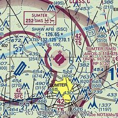
| Sectional chart |
|---|
|
| Airport distance calculator |
|---|
|
|
| Sunrise and sunset |
|---|
|
Times for 25-Feb-2026
| | Local
(UTC-5) | | Zulu
(UTC) |
|---|
| Morning civil twilight | | 06:31 | | 11:31 |
| Sunrise | | 06:56 | | 11:56 |
| Sunset | | 18:13 | | 23:13 |
| Evening civil twilight | | 18:38 | | 23:38 |
|
| Current date and time |
|---|
| Zulu (UTC) | 26-Feb-2026 04:26:32 |
|---|
| Local (UTC-5) | 25-Feb-2026 23:26:32 |
|---|
|
| METAR |
|---|
| KSMS | 260415Z AUTO 17008KT 10SM SCT100 13/09 A2995 RMK AO2 PWINO
|
KSSC
6nm W | 260355Z 19006KT 10SM BKN100 BKN170 14/09 A2994 RMK AO2A SLP140 T01370085 $
|
|
| TAF |
|---|
KSSC
6nm W | 260000Z 2600/2706 21009KT 9999 BKN180 510023 QNH2991INS BECMG 2609/2610 21010KT 9999 BKN025 OVC055 WS020/24040KT QNH2988INS BECMG 2613/2614 22012G20KT 9999 VCSH BKN015 OVC040 510004 QNH2987INS BECMG 2617/2618 24014G25KT 8000 -SHRA BKN020 OVC035 510004 QNH2985INS BECMG 2700/2701 22012G20KT 9999 VCSH OVC020 510004 QNH2983INS TX17/2620Z TN13/2610Z
|
|
| NOTAMs |
|---|
NOTAMs are issued by the DoD/FAA and will open in a separate window not controlled by AirNav.
|
|


