FAA INFORMATION EFFECTIVE 16 APRIL 2026
Location
| FAA Identifier: | EKM |
| Lat/Long: | 41-43-09.8622N 086-00-11.5883W
41-43.164370N 086-00.193138W
41.7194062,-86.0032190
(estimated) |
| Elevation: | 777.6 ft. / 237.0 m (surveyed) |
| Variation: | 04W (2005) |
| From city: | 3 miles NW of ELKHART, IN |
| Time zone: | UTC -4 (UTC -5 during Standard Time) |
| Zip code: | 46514 |
Airport Operations
| Airport use: | Open to the public |
| Activation date: | 04/1940 |
| Control tower: | yes |
| ARTCC: | CHICAGO CENTER |
| FSS: | TERRE HAUTE FLIGHT SERVICE STATION |
| NOTAMs facility: | EKM (NOTAM-D service available) |
| Attendance: | 0600-2200 |
| Wind indicator: | lighted |
| Segmented circle: | yes |
| Lights: | ACTVT MALSR RWY 27; REIL RWY 09, 18 & 36; VASI RWY 09 & 36; PAPI RWY 18 & 27 - CTAF. WHEN ATCT CLSD HIRL RWY 09/27; MIRL RWY 18/36 PRESET LOW INTST; INCR INTST - CTAF. |
| Beacon: | white-green (lighted land airport)
Operates sunset to sunrise. |
Airport Communications
| CTAF: | 119.5 |
| UNICOM: | 122.95 |
| WX AWOS-3PT: | 124.475 (574-264-9002) |
| ELKHART GROUND: | 121.8 [0700-2100 MON-FRI, 0800-1800 SAT-SUN.] |
| ELKHART TOWER: | 119.5 [0700-2100 MON-FRI, 0800-1800 SAT-SUN.] |
| SOUTH BEND APPROACH: | 118.55 |
| SOUTH BEND DEPARTURE: | 118.55 |
| CLEARANCE DELIVERY: | 121.8 119.7 ;WHEN ELKHART TWR CLSD |
| WX ASOS at SBN (14 nm W): | 120.675 (574-200-0869) |
| WX ASOS at GSH (15 nm SE): | 121.45 (574-642-4231) |
- APCH/DEP SVC PRVDD BY CHICAGO ARTCC ON 127.55/307.175 (GOSHEN RCAG) WHEN SOUTH BEND APCH CTL CLSD.
- CLEARANCE DELIVERY SVC PRVDD BY SOUTH BEND APCH CTL ON 119.7 WHEN ELKHART ATCT CLSD.
Nearby radio navigation aids
| VOR radial/distance | | VOR name | | Freq | | Var |
|---|
| GIJr102/14.4 | | GIPPER VORTAC | | 115.40 | | 00E |
| OLKr324/(36.3) | | WEBSTER LAKE VOR | | 110.40 | | 03W |
| NDB name | | Hdg/Dist | | Freq | | Var | | ID |
|---|
| MISHA | | 090/9.7 | | 341 | | 05W | | SB | ... -... |
| STURGIS | | 262/26.1 | | 382 | | 04W | | IRS | .. .-. ... |
Airport Services
| Fuel available: | 100LL JET-A |
| Parking: | hangars and tiedowns |
| Airframe service: | MAJOR |
| Powerplant service: | MINOR |
| Bottled oxygen: | LOW |
| Bulk oxygen: | NONE |
Runway Information
Runway 9/27
| Dimensions: | 6500 x 120 ft. / 1981 x 37 m |
| Surface: | concrete/grooved, in excellent condition |
| Weight bearing capacity: | | Single wheel: | 40.0 | | Double wheel: | 60.0 | | Double tandem: | 120.0 |
|
| Runway edge lights: | high intensity |
| RUNWAY 9 | | RUNWAY 27 |
| Latitude: | 41-43.254078N | | 41-43.256065N |
| Longitude: | 086-01.163282W | | 085-59.734810W |
| Elevation: | 770.4 ft. | | 777.1 ft. |
| Traffic pattern: | left | | left |
| Runway heading: | 094 magnetic, 090 true | | 274 magnetic, 270 true |
| Declared distances: | TORA:6500 TODA:6500 ASDA:6500 LDA:6500 | | TORA:6500 TODA:6500 ASDA:6500 LDA:6500 |
| Markings: | precision, in good condition | | precision, in good condition |
| Visual slope indicator: | 4-box VASI on left (3.00 degrees glide path) | | 4-light PAPI on left (3.00 degrees glide path) |
| RVR equipment: | rollout | | touchdown |
| Approach lights: | | | MALSR: 1,400 foot medium intensity approach lighting system with runway alignment indicator lights |
| Runway end identifier lights: | yes | | |
| Touchdown point: | yes, no lights | | yes, no lights |
| Instrument approach: | | | ILS |
| Obstructions: | 40 ft. trees, 1050 ft. from runway, 21:1 slope to clear | | 69 ft. trees, 2645 ft. from runway, 35:1 slope to clear |
Runway 18/36
| Dimensions: | 3999 x 75 ft. / 1219 x 23 m |
| Surface: | asphalt/grooved, in fair condition |
| Weight bearing capacity: | | Single wheel: | 45.0 | | Double wheel: | 65.0 |
|
| Runway edge lights: | medium intensity |
| Runway edge markings: | FADED. |
| RUNWAY 18 | | RUNWAY 36 |
| Latitude: | 41-43.334963N | | 41-42.683117N |
| Longitude: | 085-59.596627W | | 085-59.473380W |
| Elevation: | 777.2 ft. | | 771.8 ft. |
| Traffic pattern: | left | | left |
| Runway heading: | 176 magnetic, 172 true | | 356 magnetic, 352 true |
| Declared distances: | TORA:4001 TODA:4001 ASDA:4001 LDA:4001 | | TORA:4001 TODA:4001 ASDA:4001 LDA:4001 |
| Markings: | nonprecision, in poor condition | | nonprecision, in poor condition |
| Visual slope indicator: | 4-light PAPI on left (3.00 degrees glide path) | | 4-box VASI on left (4.00 degrees glide path)
VASI UNUSBL 7 DEG LEFT & RIGHT OF CNTRLN. |
| Runway end identifier lights: | yes | | yes |
| Touchdown point: | yes, no lights | | yes, no lights |
| Obstructions: | 40 ft. trees, 1200 ft. from runway, 25:1 slope to clear | | 62 ft. trees, 1200 ft. from runway, 250 ft. both sides of centerline, 16:1 slope to clear
7 FT BRUSH L & R OF CNTRLN 100 FT FM THR. |
Runway 8/26
| Dimensions: | 2480 x 250 ft. / 756 x 76 m |
| Surface: | turf, in excellent condition |
| Runway edge markings: | WHITE CORNER MKRS. |
| Operational restrictions: | VFR OPS DRG ATCT HRS ONLY. |
| RUNWAY 8 | | RUNWAY 26 |
| Latitude: | 41-43.174937N | | 41-43.179283N |
| Longitude: | 086-00.856143W | | 086-00.311190W |
| Elevation: | 769.3 ft. | | 773.3 ft. |
| Traffic pattern: | left | | left |
| Runway heading: | 093 magnetic, 089 true | | 273 magnetic, 269 true |
| Declared distances: | TORA:2480 TODA:2480 ASDA:2480 LDA:2480 | | TORA:2480 TODA:2480 ASDA:2480 LDA:2480 |
| Markings: | , in fair condition | | , in fair condition |
| Touchdown point: | yes, no lights | | yes, no lights |
Airport Ownership and Management from official FAA records
| Ownership: | Publicly-owned |
| Owner: | CITY OF ELKHART
1211 CO RD 6 W
ELKHART, IN 46514
Phone 574-264-5217 |
| Manager: | ANDY JONES
1211 CO RD 6 W
ELKHART, IN 46514
Phone 574-264-5217 |
Additional Remarks
| E94 | SWARS. |
| - | TWY MKD WITH REFLECTORS; TWY A UNAVBL TO ACFT WITH MORE THAN 30 PAX SEATS. |
| - | FOR CD WHEN ATCT CLSD, CTC SOUTH BEND ATCT ON FREQ. WHEN SOUTH BEND ATCT CLSD, CTC CHICAGO ARTCC AT 630-906-8921. |
Instrument Procedures
NOTE: All procedures below are presented as PDF files. If you need a reader for these files, you should download the free Adobe Reader.NOT FOR NAVIGATION. Please procure official charts for flight.
FAA instrument procedures published for use from 16 April 2026 at 0901Z to 14 May 2026 at 0900Z.
IAPs - Instrument Approach Procedures |
|---|
| ILS OR LOC RWY 27 | |
download (264KB) |
| RNAV (GPS) RWY 09 | |
download (208KB) |
| RNAV (GPS) RWY 18 | |
download (227KB) |
| RNAV (GPS) RWY 27 | |
download (274KB) |
| RNAV (GPS) RWY 36 | |
download (241KB) |
| VOR RWY 09 | |
download (236KB) |
| NOTE: Special Alternate Minimums apply | |
download (148KB) |
| NOTE: Special Take-Off Minimums/Departure Procedures apply | |
download (164KB) |
Other nearby airports with instrument procedures:
3TR - Jerry Tyler Memorial Airport (12 nm NW)
KSBN - South Bend International Airport (14 nm W)
KGSH - Goshen Municipal Airport (15 nm SE)
C03 - Nappanee Municipal Airport (17 nm S)
C91 - Dowagiac Municipal Airport (17 nm N)
|
|

Road maps at:
MapQuest
Bing
Google
| Aerial photo |
|---|
WARNING: Photo may not be current or correct
 Photo by Brandon Herzog
Photo taken 03-Nov-2016
Photo by Brandon Herzog
Photo taken 03-Nov-2016
Do you have a better or more recent aerial photo of Elkhart Municipal Airport that you would like to share? If so, please send us your photo.
|
| Sectional chart |
|---|
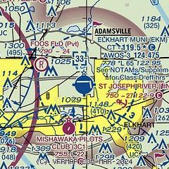
|
 Download PDF
of official airport diagram from the FAA
| Airport distance calculator |
|---|
|
|
| Sunrise and sunset |
|---|
|
Times for 24-Apr-2026
| | Local
(UTC-4) | | Zulu
(UTC) |
|---|
| Morning civil twilight | | 06:22 | | 10:22 |
| Sunrise | | 06:51 | | 10:51 |
| Sunset | | 20:33 | | 00:33 |
| Evening civil twilight | | 21:03 | | 01:03 |
|
| Current date and time |
|---|
| Zulu (UTC) | 24-Apr-2026 11:37:06 |
|---|
| Local (UTC-4) | 24-Apr-2026 07:37:06 |
|---|
|
| METAR |
|---|
| KEKM | 241115Z AUTO 17007KT 10SM CLR 18/13 A2972 RMK AO2 T01820126 $
|
KSBN
14nm W | 241054Z 17007KT 10SM FEW048 18/12 A2972 RMK AO2 SLP058 T01830122 $
|
KGSH
15nm SE | 241053Z AUTO 18011KT 10SM BKN050 BKN065 18/12 A2973 RMK AO2 SLP064 T01780117
|
|
| TAF |
|---|
KSBN
14nm W | 240520Z 2406/2506 18009KT P6SM SCT200 WS020/22040KT FM241300 21012G20KT P6SM VCSH BKN040 FM241800 26012G20KT P6SM VCSH BKN050 PROB30 2418/2422 3SM -TSRA OVC025CB FM242300 32007KT P6SM BKN050
|
|
| NOTAMs |
|---|
NOTAMs are issued by the DoD/FAA and will open in a separate window not controlled by AirNav.
|
|


