FAA INFORMATION EFFECTIVE 09 JULY 2026
Location
| FAA Identifier: | FPY |
| Lat/Long: | 30-04-14.9250N 083-34-53.5580W
30-04.248750N 083-34.892633W
30.0708125,-83.5815439
(estimated) |
| Elevation: | 44.3 ft. / 13.5 m (surveyed) |
| Variation: | 03W (2000) |
| From city: | 3 miles S of PERRY, FL |
| Time zone: | UTC -4 (UTC -5 during Standard Time) |
| Zip code: | 32347 |
Airport Operations
| Airport use: | Open to the public |
| Activation date: | 02/1944 |
| Control tower: | no |
| ARTCC: | JACKSONVILLE CENTER |
| FSS: | GAINESVILLE FLIGHT SERVICE STATION |
| NOTAMs facility: | GNV (NOTAM-D service available) |
| Attendance: | MON-FRI 0800-1700 |
| Wind indicator: | lighted |
| Segmented circle: | no |
| Lights: | ACTVT PAPI RWY 18 & 36; MIRL RWY 12/30 & 18/36 - CTAF. |
| Beacon: | white-green (lighted land airport)
Operates sunset to sunrise. |
Airport Communications
| CTAF/UNICOM: | 122.8 |
| WX AWOS-3PT: | 118.375 (850-838-3526) |
- APCH/DEP SVC PRVDD BY JACKSONVILLE ARTCC ON FREQS 127.8/352.0 (PERRY FOLEY RCAG).
Nearby radio navigation aids
| VOR radial/distance | | VOR name | | Freq | | Var |
|---|
| GEFr159/30.7 | | GREENVILLE VORTAC | | 113.65 | | 01E |
Airport Services
| Fuel available: | 100LL JET-A
100LL:24 HR CREDIT CARD SVC AVBL. |
| Parking: | tiedowns |
| Airframe service: | NONE |
| Powerplant service: | NONE |
| Bottled oxygen: | NONE |
| Bulk oxygen: | NONE |
Runway Information
Runway 18/36
| Dimensions: | 5013 x 100 ft. / 1528 x 30 m |
| Surface: | asphalt, in fair condition |
| Weight bearing capacity: | | PCN 16 /R/C/W/T | | Single wheel: | 30.0 |
|
| Runway edge lights: | medium intensity |
| RUNWAY 18 | | RUNWAY 36 |
| Latitude: | 30-04.573042N | | 30-03.746132N |
| Longitude: | 083-35.099015W | | 083-35.111575W |
| Elevation: | 42.4 ft. | | 40.5 ft. |
| Traffic pattern: | left | | left |
| Runway heading: | 184 magnetic, 181 true | | 004 magnetic, 001 true |
| Markings: | nonprecision, in good condition | | nonprecision, in good condition |
| Visual slope indicator: | 2-light PAPI on left (4.00 degrees glide path) | | 2-light PAPI on left (4.00 degrees glide path) |
| Runway end identifier lights: | no | | no |
| Touchdown point: | yes, no lights | | yes, no lights |
| Obstructions: | 46 ft. trees, 1555 ft. from runway, 230 ft. right of centerline, 29:1 slope to clear
RWY 18 APRCH SLOPE 34:1 TO AER. | | 51 ft. trees, 1935 ft. from runway, 80 ft. left of centerline, 34:1 slope to clear |
Runway 12/30
| Dimensions: | 4754 x 100 ft. / 1449 x 30 m |
| Surface: | asphalt/concrete, in excellent condition
RWY 30 FIRST 411 FT CONC. |
| Weight bearing capacity: | | PCN 11 /F/B/Y/T | | Single wheel: | 30.0 |
|
| Runway edge lights: | medium intensity |
| RUNWAY 12 | | RUNWAY 30 |
| Latitude: | 30-04.541908N | | 30-04.143595N |
| Longitude: | 083-35.056837W | | 083-34.279990W |
| Elevation: | 42.9 ft. | | 44.2 ft. |
| Traffic pattern: | left | | left |
| Runway heading: | 124 magnetic, 121 true | | 304 magnetic, 301 true |
| Markings: | basic, in good condition | | basic, in good condition |
| Runway end identifier lights: | no | | no |
| Touchdown point: | yes, no lights | | yes, no lights |
| Obstructions: | 48 ft. tree, 1815 ft. from runway, 75 ft. right of centerline, 34:1 slope to clear | | 68 ft. trees, 3640 ft. from runway, 250 ft. left of centerline |
Airport Ownership and Management from official FAA records
| Ownership: | Publicly-owned |
| Owner: | TAYLOR COUNTY
201 EAST GREEN STREET
PERRY, FL 32347
Phone 850-838-3553
AIRPORT PHYSICAL ADDRESS: 481 INDUSTRIAL DRIVE, PERRY, FL 32348 |
| Manager: | WARD KETRING
481 INDUSTRIAL DRIVE
PERRY, FL 32348
Phone 850-838-3519
850-838-6075. |
Additional Remarks
| - | 300 FT CONC SWY ON RWY 12. |
| - | FOR CD CTC JACKSONVILLE ARTCC AT 904-845-1592. |
Instrument Procedures
NOTE: All procedures below are presented as PDF files. If you need a reader for these files, you should download the free Adobe Reader.NOT FOR NAVIGATION. Please procure official charts for flight.
FAA instrument procedures published for use from 09 July 2026 at 0901Z to 06 August 2026 at 0900Z.
IAPs - Instrument Approach Procedures |
|---|
| RNAV (GPS) RWY 18 | |
download (235KB) |
| RNAV (GPS) RWY 36 | |
download (211KB) |
| NOTE: Special Alternate Minimums apply | |
download (123KB) |
| NOTE: Special Take-Off Minimums/Departure Procedures apply | |
download (413KB) |
Other nearby airports with instrument procedures:
24J - Suwannee County Airport (32 nm NE)
KCTY - Cross City Airport (36 nm SE)
4J5 - Quitman Brooks County Airport (44 nm N)
KTLH - Tallahassee International Airport (44 nm NW)
KVLD - Valdosta Regional Airport (45 nm N)
|
|

Road maps at:
MapQuest
Bing
Google
| Aerial photo |
|---|
WARNING: Photo may not be current or correct
 Photo taken 26-Nov-2017
looking northeast.
Photo taken 26-Nov-2017
looking northeast.
Do you have a better or more recent aerial photo of Perry-Foley Airport that you would like to share? If so, please send us your photo.
|
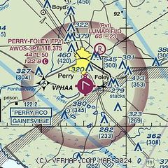
| Sectional chart |
|---|
|
| Airport distance calculator |
|---|
|
|
| Sunrise and sunset |
|---|
|
Times for 01-Aug-2026
| | Local
(UTC-4) | | Zulu
(UTC) |
|---|
| Morning civil twilight | | 06:28 | | 10:28 |
| Sunrise | | 06:54 | | 10:54 |
| Sunset | | 20:27 | | 00:27 |
| Evening civil twilight | | 20:53 | | 00:53 |
|
| Current date and time |
|---|
| Zulu (UTC) | 01-Aug-2026 11:21:36 |
|---|
| Local (UTC-4) | 01-Aug-2026 07:21:36 |
|---|
|
| METAR |
|---|
| KFPY | 011055Z AUTO 00000KT 7SM SCT020 SCT043 SCT050 27/26 A2993 RMK AO2 LTG DSNT S AND SW T02650257
|
|
| TAF |
|---|
KTLH
44nm NW | 011024Z 0110/0206 25004KT P6SM SCT100 TEMPO 0110/0113 BKN010 FM011300 25006KT P6SM VCSH SCT025 BKN035 FM011600 24008KT 4SM SHRA VCTS SCT025CB OVC040 FM020100 21004KT P6SM SCT030
|
KVLD
45nm N | 010911Z 0109/0206 VRB03KT P6SM BKN004 FM011300 21003KT P6SM SCT015 FM011600 23005KT P6SM VCSH SCT025 BKN035 FM011800 22007KT 4SM SHRA VCTS SCT025CB OVC040 FM020200 20004KT P6SM SCT040
|
|
| NOTAMs |
|---|
NOTAMs are issued by the DoD/FAA and will open in a separate window not controlled by AirNav.
|
|


