FAA INFORMATION EFFECTIVE 09 JULY 2026
Location
| FAA Identifier: | FWQ |
| Lat/Long: | 40-12-35.0000N 079-49-53.2000W
40-12.583333N 079-49.886667W
40.2097222,-79.8314444
(estimated) |
| Elevation: | 1228.2 ft. / 374.4 m (surveyed) |
| Variation: | 09W (2005) |
| From city: | 5 miles E of MONONGAHELA, PA |
| Time zone: | UTC -4 (UTC -5 during Standard Time) |
| Zip code: | 15012 |
Airport Operations
| Airport use: | Open to the public |
| Control tower: | no |
| ARTCC: | CLEVELAND CENTER |
| FSS: | ALTOONA FLIGHT SERVICE STATION |
| NOTAMs facility: | AOO (NOTAM-D service available) |
| Attendance: | MON - FRI 0700 - 1700
AFT HRS CTC 724-640-6349/2409. |
| Wind indicator: | lighted |
| Segmented circle: | yes |
| Lights: | ACTVT REIL RWY 08/26; MIRL RWY 08/26 - CTAF. |
| Beacon: | white-green (lighted land airport)
Operates sunset to sunrise. |
Airport Communications
| CTAF/UNICOM: | 122.8 |
| WX AWOS-3PT: | 118.475 (724-379-5815) |
| PITTSBURGH APPROACH: | 119.35 |
| PITTSBURGH DEPARTURE: | 119.35 |
| CLASS B: | 119.35 |
| WX ASOS at AGC (10 nm NW): | 120.55 (412-466-8968) |
| WX AWOS-A at 42PN (17 nm NW): | PHONE 412-442-2213 |
| WX AWOS-3P at VVS (17 nm SE): | 133.325 (724-626-8745) |
| WX AWOS-3 at LBE (20 nm E): | PHONE 724-537-0671 |
Nearby radio navigation aids
| VOR radial/distance | | VOR name | | Freq | | Var |
|---|
| AGCr122/10.4 | | ALLEGHENY VOR/DME | | 110.00 | | 09W |
| HLGr102/33.9 | | WHEELING VOR/DME | | 114.25 | | 07W |
| MGWr007/39.2 | | MORGANTOWN VOR/DME | | 111.60 | | 05W |
Airport Services
| Fuel available: | 100LL JET-A JET-A+ |
| Parking: | hangars and tiedowns |
| Airframe service: | MAJOR |
| Powerplant service: | MAJOR |
| Bottled oxygen: | NONE |
| Bulk oxygen: | NONE |
Runway Information
Runway 8/26
| Dimensions: | 4002 x 75 ft. / 1220 x 23 m |
| Surface: | asphalt/grooved, in good condition |
| Weight bearing capacity: | | Single wheel: | 26.0 | | Double wheel: | 30.0 |
|
| Runway edge lights: | medium intensity |
| RUNWAY 8 | | RUNWAY 26 |
| Latitude: | 40-12.457363N | | 40-12.709950N |
| Longitude: | 079-50.284337W | | 079-49.490350W |
| Elevation: | 1228.1 ft. | | 1222.8 ft. |
| Traffic pattern: | left
RIGHT TRAFFIC HELICOPTERS/ULTRALIGHTS. | | left
RIGHT TRAFFIC HELICOPTERS/ULTRALIGHTS. |
| Runway heading: | 076 magnetic, 067 true | | 256 magnetic, 247 true |
| Markings: | nonprecision, in good condition | | nonprecision, in good condition |
| Visual slope indicator: | 4-box VASI on right (3.00 degrees glide path) | | 4-box VASI on left (3.00 degrees glide path) |
| Runway end identifier lights: | yes | | yes |
| Touchdown point: | yes, no lights | | yes, no lights |
| Obstructions: | 127 ft. tower, 4215 ft. from runway, 245 ft. right of centerline, 31:1 slope to clear | | 59 ft. trees, 2095 ft. from runway, 179 ft. left of centerline, 32:1 slope to clear |
Airport Ownership and Management from official FAA records
| Ownership: | Publicly-owned |
| Owner: | WESTMORELAND CO ARPT AUTH
148 AVIATION LANE, SUITE 103
LATROBE, PA 15650
Phone 724-539-8100 |
| Manager: | GABE MONZO
605 AIRPORT RD
BELLE VERNON, PA 15012
Phone 724-379-6980 |
Additional Remarks
| - | DEER & BIRDS ON & INVOF ARPT. |
| - | FOR CD CTC PITTSBURGH APCH AT 412-472-5591. |
Instrument Procedures
NOTE: All procedures below are presented as PDF files. If you need a reader for these files, you should download the free Adobe Reader.NOT FOR NAVIGATION. Please procure official charts for flight.
FAA instrument procedures published for use from 09 July 2026 at 0901Z to 06 August 2026 at 0900Z.
IAPs - Instrument Approach Procedures |
|---|
| RNAV (GPS) RWY 08 | |
download (197KB) |
| RNAV (GPS) RWY 26 | |
download (221KB) |
| NOTE: Special Take-Off Minimums/Departure Procedures apply | |
download (434KB) |
Other nearby airports with instrument procedures:
G05 - Finleyville Airpark (8 nm W)
KAGC - Allegheny County Airport (10 nm NW)
KVVS - Joseph A Hardy Connellsville Airport (17 nm SE)
KLBE - Arnold Palmer Regional Airport (20 nm E)
KAFJ - Washington County Airport (21 nm W)
|
|

Road maps at:
MapQuest
Bing
Google
| Aerial photo |
|---|
WARNING: Photo may not be current or correct
 Photo by John Diehl
Photo taken 16-Jul-2015
looking northeast.
Photo by John Diehl
Photo taken 16-Jul-2015
looking northeast.
Do you have a better or more recent aerial photo of Rostraver Airport that you would like to share? If so, please send us your photo.
|
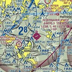
| Sectional chart |
|---|
|
| Airport distance calculator |
|---|
|
|
| Sunrise and sunset |
|---|
|
Times for 28-Jul-2026
| | Local
(UTC-4) | | Zulu
(UTC) |
|---|
| Morning civil twilight | | 05:44 | | 09:44 |
| Sunrise | | 06:14 | | 10:14 |
| Sunset | | 20:37 | | 00:37 |
| Evening civil twilight | | 21:08 | | 01:08 |
|
| Current date and time |
|---|
| Zulu (UTC) | 29-Jul-2026 02:32:22 |
|---|
| Local (UTC-4) | 28-Jul-2026 22:32:22 |
|---|
|
| METAR |
|---|
| KP53 | 290156Z AUTO 00000KT 17/14 A2995 RMK AO1 SLP141 T01670139 $
|
KAGC
9nm NW | 290202Z 34010KT 8SM CLR 22/18 A2973
|
KVVS
17nm SE | 290215Z AUTO 00000KT 10SM CLR 21/19 A2975 RMK AO2 T02090187
|
|
| TAF |
|---|
KAGC
9nm NW | 281853Z 2819/2918 31012G16KT P6SM -SHRA SCT015 BKN035 FM282100 33010KT P6SM SCT025 FM290600 31006KT P6SM BKN006 FM291400 32008G16KT P6SM BKN035
|
|
| NOTAMs |
|---|
NOTAMs are issued by the DoD/FAA and will open in a separate window not controlled by AirNav.
|
|

