FAA INFORMATION EFFECTIVE 14 MAY 2026
Location
| FAA Identifier: | GEZ |
| Lat/Long: | 39-34-59.3000N 085-48-17.3000W
39-34.988333N 085-48.288333W
39.5831389,-85.8048056
(estimated) |
| Elevation: | 802.5 ft. / 244.6 m (surveyed) |
| Variation: | 04W (2000) |
| From city: | 4 miles NW of SHELBYVILLE, IN |
| Time zone: | UTC -4 (UTC -5 during Standard Time) |
| Zip code: | 46176 |
Airport Operations
| Airport use: | Open to the public |
| Activation date: | 11/1956 |
| Control tower: | no |
| ARTCC: | INDIANAPOLIS CENTER |
| FSS: | TERRE HAUTE FLIGHT SERVICE STATION |
| NOTAMs facility: | GEZ (NOTAM-D service available) |
| Attendance: | 0800-1800
ATNDD IREG ON HOLS |
| Pattern altitude: | 1602.5 ft. MSL |
| Wind indicator: | lighted |
| Segmented circle: | no |
| Lights: | ACTVT REIL RWY 01 & 19; PAPI RWY 01; VASI RWY 19; MIRL RWY 01/19 - CTAF. |
| Beacon: | white-green (lighted land airport)
Operates sunset to sunrise. |
Airport Communications
| CTAF/UNICOM: | 122.8 |
| WX ASOS: | 121.55 (317-398-0246) |
| INDIANAPOLIS APPROACH: | 127.15 [1230-0400Z++] |
| INDIANAPOLIS DEPARTURE: | 127.15 [1230-0400Z++] |
| CLANG RNAV STAR: | 128.175 |
| WX AWOS-3P at HFY (13 nm W): | 118.525 (317-882-5862) |
| WX AWOS-3PT at MQJ (16 nm N): | 124.175 (317-335-3037) |
| WX AWOS-3 at 8A4 (19 nm NW): | 135.525 (317-955-3160) |
| WX AWOS-3 at BAK (20 nm S): | 119.75 (812-376-7584) |
Nearby radio navigation aids
| VOR radial/distance | | VOR name | | Freq | | Var |
|---|
| SHBr162/3.1 | | SHELBYVILLE VOR/DME | | 116.15 | | 01E |
| VHPr117/29.5 | | BRICKYARD VORTAC | | 116.30 | | 01E |
| NDB name | | Hdg/Dist | | Freq | | Var | | ID |
|---|
| NEW CASTLE | | 238/28.6 | | 385 | | 06W | | UWL | ..- .-- .-.. |
Airport Services
| Fuel available: | 100LL JET-A JET-A+
100LL:100LL SELF SERVE AVBL |
| Parking: | hangars and tiedowns |
| Airframe service: | MAJOR |
| Powerplant service: | MAJOR |
| Bottled oxygen: | NONE |
| Bulk oxygen: | NONE |
Runway Information
Runway 1/19
| Dimensions: | 5000 x 100 ft. / 1524 x 30 m |
| Surface: | asphalt/grooved, in good condition |
| Weight bearing capacity: | | Single wheel: | 30.0 | | Double wheel: | 40.0 |
|
| Runway edge lights: | medium intensity |
| RUNWAY 1 | | RUNWAY 19 |
| Latitude: | 39-34.775032N | | 39-35.596103N |
| Longitude: | 085-48.280248W | | 085-48.196250W |
| Elevation: | 801.3 ft. | | 802.3 ft. |
| Traffic pattern: | left | | left |
| Runway heading: | 009 magnetic, 005 true | | 189 magnetic, 185 true |
| Markings: | nonprecision, in good condition | | nonprecision, in good condition |
| Visual slope indicator: | 2-light PAPI on left (3.00 degrees glide path) | | 4-box VASI on left (3.00 degrees glide path) |
| Runway end identifier lights: | yes | | yes |
| Touchdown point: | yes, no lights | | yes, no lights |
Runway 9/27
| Dimensions: | 2671 x 190 ft. / 814 x 58 m |
| Surface: | turf, in good condition |
| Runway edge markings: | RWY BEGINS W SIDE OF TWY A; GRASS LINE MARKS RWY EDGES. |
| RUNWAY 9 | | RUNWAY 27 |
| Latitude: | 39-34.627833N | | 39-34.611167N |
| Longitude: | 085-48.667833W | | 085-48.099833W |
| Elevation: | 790.0 ft. | | 800.0 ft. |
| Traffic pattern: | left | | left |
| Runway heading: | 096 magnetic, 092 true | | 276 magnetic, 272 true |
| Displaced threshold: | 446 ft.
RWY 09/27 DSPLCD THLDS MKD WITH YELLOW CONES. | | 289 ft. |
| Markings: | none | | none |
| Runway end identifier lights: | no | | no |
| Touchdown point: | yes, no lights | | yes, no lights |
| Obstructions: | 150 ft. road, 15 ft. from runway, 10:1 slope to clear
APCH SLOPE 40:1 AT DSPLCD THR. | | 23 ft. bldg, lighted, 325 ft. from runway, 120 ft. right of centerline, 14:1 slope to clear
APCH RATIO 27:1 TO DSPLCD THLD. |
Airport Ownership and Management from official FAA records
| Ownership: | Publicly-owned |
| Owner: | SHELBYVILLE BOAC
44 W WASHINGTON ST
SHELBYVILLE, IN 46176
Phone 317-398-6624 |
| Manager: | MARANDA SMITH
3529 N 100 WEST
SHELBYVILLE, IN 46176
Phone 317-392-1284 |
Additional Remarks
| - | HELICOPTER TFC ALL HRS. ANG HELI LCTD W OF ARPT. |
| - | CTC ANG OPS 41.5/143.6/347.55. |
| - | AP HEL LESS THAN 5000 LB VFR TFC PAT ALT 500 FT AGL. |
Instrument Procedures
NOTE: All procedures below are presented as PDF files. If you need a reader for these files, you should download the free Adobe Reader.NOT FOR NAVIGATION. Please procure official charts for flight.
FAA instrument procedures published for use from 14 May 2026 at 0901Z to 11 June 2026 at 0900Z.
STARs - Standard Terminal Arrivals |
|---|
| CLANG ONE (RNAV) **NEW** | |
download (139KB) |
IAPs - Instrument Approach Procedures |
|---|
| RNAV (GPS) RWY 01 | |
download (218KB) |
| RNAV (GPS) RWY 19 | |
download (252KB) |
| VOR RWY 19 | |
download (167KB) |
| NOTE: Special Alternate Minimums apply | |
download (60KB) |
Departure Procedures |
|---|
| DAWNN ONE | |
2 pages:
[1] [2] (251KB) |
| HOOSIER FIVE | |
download (188KB) |
| MAREO ONE (RNAV) **NEW** | |
download (136KB) |
| MEARZ SEVEN | |
2 pages:
[1] [2] (244KB) |
| ROCKY ONE | |
download (201KB) |
| NOTE: Special Take-Off Minimums/Departure Procedures apply | |
download (164KB) |
Other nearby airports with instrument procedures:
KHFY - Indy South Greenwood Airport (13 nm W)
KMQJ - Indianapolis Regional Airport (16 nm N)
KBAK - Columbus Municipal Airport (20 nm S)
I34 - Greensburg Municipal Airport (20 nm SE)
KUMP - Indianapolis Metro Airport (24 nm NW)
|
|

Road maps at:
MapQuest
Bing
Google
| Aerial photo |
|---|
WARNING: Photo may not be current or correct
 Photo taken 03-Nov-2007
from FL340
Photo taken 03-Nov-2007
from FL340
Do you have a better or more recent aerial photo of Shelbyville Municipal Airport that you would like to share? If so, please send us your photo.
|
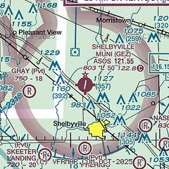
| Sectional chart |
|---|
|
CAUTION: Diagram may not be current

| Airport distance calculator |
|---|
|
|
| Sunrise and sunset |
|---|
|
Times for 09-Jun-2026
| | Local
(UTC-4) | | Zulu
(UTC) |
|---|
| Morning civil twilight | | 05:44 | | 09:44 |
| Sunrise | | 06:16 | | 10:16 |
| Sunset | | 21:08 | | 01:08 |
| Evening civil twilight | | 21:41 | | 01:41 |
|
| Current date and time |
|---|
| Zulu (UTC) | 10-Jun-2026 00:20:04 |
|---|
| Local (UTC-4) | 09-Jun-2026 20:20:04 |
|---|
|
| METAR |
|---|
| KGEZ | 092353Z AUTO 21012KT 10SM FEW037 29/23 A2990 RMK AO2 LTG DSNT NW SLP117 T02940228 10311 20294 56009
|
KHFY
13nm W | 092355Z AUTO 19013G17KT 10SM SCT029 SCT035 BKN043 28/22 A2991 RMK AO2 T02820221 10300 20279
|
KMQJ
16nm N | 092355Z AUTO 19010KT 1SM HZ FEW037 29/26 A2990 RMK AO2 LTG DSNT W T02910257
|
KBAK
19nm S | 092345Z 20010KT 10SM CLR 29/24 A2991
|
|
| TAF |
|---|
KIND
24nm W | 092041Z 0921/1024 21012G18KT P6SM BKN050 FM100000 20006KT P6SM VCTS OVC040CB TEMPO 1000/1003 2SM -TSRA OVC015CB FM100400 21008KT P6SM BKN035 BKN100 FM101500 23011G20KT P6SM BKN035 BKN100 FM101900 23013G24KT P6SM SCT050 SCT100
|
|
| NOTAMs |
|---|
NOTAMs are issued by the DoD/FAA and will open in a separate window not controlled by AirNav.
|
|


