FAA INFORMATION EFFECTIVE 14 MAY 2026
Location
| FAA Identifier: | UMP |
| Lat/Long: | 39-56-07.4345N 086-02-42.2438W
39-56.123908N 086-02.704063W
39.9353985,-86.0450677
(estimated) |
| Elevation: | 811.3 ft. / 247.3 m (surveyed) |
| Variation: | 03W (1995) |
| From city: | 8 miles NE of INDIANAPOLIS, IN |
| Time zone: | UTC -4 (UTC -5 during Standard Time) |
| Zip code: | 46038 |
Airport Operations
| Airport use: | Open to the public |
| Activation date: | 11/1961 |
| Control tower: | no |
| ARTCC: | INDIANAPOLIS CENTER |
| FSS: | TERRE HAUTE FLIGHT SERVICE STATION |
| NOTAMs facility: | HUF (NOTAM-D service available) |
| Attendance: | 0800-1900 |
| Wind indicator: | lighted |
| Segmented circle: | yes |
| Lights: | ACTVT REIL RWY 15 AND 33, MIRL RWY 15/33 - CTAF. |
| Beacon: | white-green (lighted land airport)
Operates sunset to sunrise. |
Airport Communications
| CTAF/UNICOM: | 123.0 |
| WX AWOS-3PT: | 119.375 (317-842-3911) |
| INDIANAPOLIS APPROACH: | 127.15 |
| INDIANAPOLIS DEPARTURE: | 127.15 |
| CLEARANCE DELIVERY: | 121.625 |
| CLANG RNAV STAR: | 128.175 |
| RACYR STAR: | 128.175 |
| WX AWOS-3PT at MQJ (9 nm SE): | 124.175 (317-335-3037) |
| WX AWOS-3PT at TYQ (11 nm NW): | 120.725 (317-769-3154) |
| WX AWOS-3 at 8A4 (11 nm SW): | 135.525 (317-955-3160) |
| WX ASOS at EYE (13 nm SW): | 121.575 (317-329-1754) |
| WX ASOS at IND (17 nm SW): | PHONE 317-220-6243 |
| WX AWOS-3P at HFY (19 nm S): | 118.525 (317-882-5862) |
Nearby radio navigation aids
| VOR radial/distance | | VOR name | | Freq | | Var |
|---|
| VHPr063/16.5 | | BRICKYARD VORTAC | | 116.30 | | 01E |
| SHBr330/20.8 | | SHELBYVILLE VOR/DME | | 116.15 | | 01E |
| MZZr210/37.4 | | MARION VOR/DME | | 108.60 | | 03W |
| NDB name | | Hdg/Dist | | Freq | | Var | | ID |
|---|
| NEW CASTLE | | 282/33.6 | | 385 | | 06W | | UWL | ..- .-- .-.. |
Airport Services
| Fuel available: | 100LL JET-A |
| Parking: | hangars and tiedowns |
| Airframe service: | MAJOR |
| Powerplant service: | MAJOR |
| Bottled oxygen: | HIGH |
| Bulk oxygen: | NONE |
Runway Information
Runway 15/33
| Dimensions: | 4004 x 100 ft. / 1220 x 30 m |
| Surface: | asphalt/grooved, in good condition |
| Weight bearing capacity: | | PCN 17 /F/C/X/T | | Single wheel: | 17.0 |
|
| Runway edge lights: | medium intensity |
| RUNWAY 15 | | RUNWAY 33 |
| Latitude: | 39-56.396000N | | 39-55.851815N |
| Longitude: | 086-02.946000W | | 086-02.462127W |
| Elevation: | 787.1 ft. | | 811.2 ft. |
| Traffic pattern: | left | | left |
| Runway heading: | 149 magnetic, 146 true | | 329 magnetic, 326 true |
| Displaced threshold: | 156 ft. | | no |
| Markings: | nonprecision, in good condition | | nonprecision, in good condition |
| Visual slope indicator: | 4-light PAPI on left (3.00 degrees glide path) | | 4-light PAPI on left (3.50 degrees glide path) |
| Runway end identifier lights: | yes | | yes |
| Touchdown point: | yes, no lights | | yes, no lights |
| Obstructions: | 11 ft. road, 275 ft. from runway, 260 ft. right of centerline, 6:1 slope to clear
APCH SLOPE 21:1 AT DSPLCD THR; 37 FT TREES 800 FT FM DSPLCD THR 260 FT LEFT. | | none |
Airport Ownership and Management from official FAA records
| Ownership: | Publicly-owned |
| Owner: | INDIANAPOLIS ARPT AUTH
7800 COL. H. WEIR COOK MEM. DRIVE, SUITE 100
INDIANAPOLIS, IN 46241-4941
Phone (317) 487-7243 |
| Manager: | KEITH BERLEN
7800 COL H. WEIR COOK MEM. DRIVE, SUITE 100
INDIANAPOLIS, IN 46241-4941
Phone (317) 487-7243 |
Additional Remarks
| - | OUTSIDE PHONE AVBL. |
| - | ACFT TAKEOFF/LANDING FM RY 15 DURING CALM WIND/CROSSWIND CONDITIONS; DURING ANY QUESTIONABLE PERIOD RY 15 SHALL BE PREFERRED RY - CALL AMGR 317-487-9594. |
| - | FBO PHONE NUMBER - 317-849-0840 |
| - | 500 FT AGL MOORED HOT AIR BALLOON LCTD APRXLY 4.4 MILES NORTH-NORTHWEST OF ARPT. BALLOON WILL OPER DLY FROM 1300-2200Z++ AND IS INTERNALLY ILLUMINATED. |
Instrument Procedures
NOTE: All procedures below are presented as PDF files. If you need a reader for these files, you should download the free Adobe Reader.NOT FOR NAVIGATION. Please procure official charts for flight.
FAA instrument procedures published for use from 14 May 2026 at 0901Z to 11 June 2026 at 0900Z.
STARs - Standard Terminal Arrivals |
|---|
| CLANG ONE (RNAV) **NEW** | |
download (139KB) |
| RACYR SIX | |
download (204KB) |
IAPs - Instrument Approach Procedures |
|---|
| RNAV (GPS) RWY 15 | |
download (245KB) |
| RNAV (GPS) RWY 33 | |
download (247KB) |
| VOR RWY 33 | |
download (220KB) |
| NOTE: Special Alternate Minimums apply | |
download (150KB) |
Departure Procedures |
|---|
| DAWNN ONE | |
2 pages:
[1] [2] (280KB) |
| HOOSIER FIVE | |
download (213KB) |
| MAREO ONE (RNAV) **NEW** | |
download (146KB) |
| MEARZ SEVEN | |
2 pages:
[1] [2] (273KB) |
| ROCKY ONE | |
download (223KB) |
| NOTE: Special Take-Off Minimums/Departure Procedures apply | |
download (468KB) |
Other nearby airports with instrument procedures:
KMQJ - Indianapolis Regional Airport (9 nm SE)
KTYQ - Indianapolis Executive Airport (11 nm NW)
KEYE - Eagle Creek Airpark (13 nm SW)
5I4 - Sheridan Airport (17 nm NW)
KIND - Indianapolis International Airport (17 nm SW)
KHFY - Indy South Greenwood Airport (19 nm S)
|
|

Road maps at:
MapQuest
Bing
Google
| Aerial photo |
|---|
WARNING: Photo may not be current or correct
 Photo by Martin Dennett
Photo taken 24-Jul-2007
Photo by Martin Dennett
Photo taken 24-Jul-2007
Do you have a better or more recent aerial photo of Indianapolis Metro Airport that you would like to share? If so, please send us your photo.
|
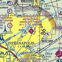
| Sectional chart |
|---|
|
CAUTION: Diagram may not be current

| Airport distance calculator |
|---|
|
|
| Sunrise and sunset |
|---|
|
Times for 23-May-2026
| | Local
(UTC-4) | | Zulu
(UTC) |
|---|
| Morning civil twilight | | 05:52 | | 09:52 |
| Sunrise | | 06:24 | | 10:24 |
| Sunset | | 20:58 | | 00:58 |
| Evening civil twilight | | 21:30 | | 01:30 |
|
| Current date and time |
|---|
| Zulu (UTC) | 24-May-2026 02:46:41 |
|---|
| Local (UTC-4) | 23-May-2026 22:46:41 |
|---|
|
| METAR |
|---|
| KUMP | 240235Z AUTO 19004KT 9SM CLR 17/17 A3005 RMK AO2 T01740169
|
KMQJ
9nm SE | 240235Z AUTO 17005KT 10SM CLR 16/16 A3004 RMK AO2 T01650165
|
KTYQ
11nm NW | 240235Z AUTO 19006KT 10SM CLR 17/15 A3004 RMK AO2 T01660150
|
KEYE
13nm SW | 240153Z AUTO 17003KT 10SM CLR 18/16 A3004 RMK AO2 SLP168 T01780156
|
KIND
17nm SW | 240224Z 21003KT 10SM BKN015 OVC150 17/16 A3005 RMK AO2 T01720156
|
KHFY
19nm S | 240235Z AUTO 00000KT 10SM BKN015 16/15 A3006 RMK AO2 T01620149
|
|
| TAF |
|---|
KIND
17nm SW | 232026Z 2320/2424 25009KT P6SM OVC017 FM240200 18004KT P6SM SCT030 FM240900 00000KT 4SM BR OVC007 FM241400 18006KT P6SM OVC015 PROB30 2414/2418 P6SM -RA OVC015
|
|
| NOTAMs |
|---|
NOTAMs are issued by the DoD/FAA and will open in a separate window not controlled by AirNav.
|
|


