FAA INFORMATION EFFECTIVE 16 APRIL 2026
Location
| FAA Identifier: | EYE |
| Lat/Long: | 39-49-50.5820N 086-17-39.7880W
39-49.843033N 086-17.663133W
39.8307172,-86.2943856
(estimated) |
| Elevation: | 822.9 ft. / 250.8 m (surveyed) |
| Variation: | 05W (2020) |
| From city: | 7 miles W of INDIANAPOLIS, IN |
| Time zone: | UTC -4 (UTC -5 during Standard Time) |
| Zip code: | 46254 |
Airport Operations
| Airport use: | Open to the public |
| Activation date: | 12/1966 |
| Control tower: | no |
| ARTCC: | INDIANAPOLIS CENTER |
| FSS: | TERRE HAUTE FLIGHT SERVICE STATION |
| NOTAMs facility: | EYE (NOTAM-D service available) |
| Attendance: | 0700-DUSK |
| Wind indicator: | lighted |
| Segmented circle: | yes |
| Lights: | MIRL RY 03/21 PRESET ON LOW INTST; TO INCR INTST & ACTVT MALS RY 21 & REIL RY 03 - CTAF. |
| Beacon: | white-green (lighted land airport)
Operates sunset to sunrise. |
Airport Communications
| CTAF/UNICOM: | 122.8 |
| WX ASOS: | 121.575 (317-329-1754) |
| INDIANAPOLIS APPROACH: | 119.05 |
| INDIANAPOLIS DEPARTURE: | 119.05 |
| CLEARANCE DELIVERY: | 128.6 |
| CLANG STAR: | 128.175 |
| RACYR STAR: | 128.175 |
| WX ASOS at IND (7 nm S): | PHONE 317-220-6243 |
| WX AWOS-3 at 8A4 (8 nm SE): | 135.525 (317-955-3160) |
| WX AWOS-3PT at 2R2 (10 nm SW): | 118.025 (317-718-4872) |
| WX AWOS-3PT at TYQ (12 nm N): | 120.725 (317-769-3154) |
| WX AWOS-3PT at UMP (13 nm NE): | 119.375 (317-842-3911) |
| WX AWOS-3P at HFY (15 nm SE): | 118.525 (317-882-5862) |
| WX AWOS-3PT at MQJ (18 nm E): | 124.175 (317-335-3037) |
Nearby radio navigation aids
| VOR radial/distance | | VOR name | | Freq | | Var |
|---|
| VHPr073/3.5 | | BRICKYARD VORTAC | | 116.30 | | 01E |
| SHBr298/24.7 | | SHELBYVILLE VOR/DME | | 116.15 | | 01E |
| NDB name | | Hdg/Dist | | Freq | | Var | | ID |
|---|
| CRAWFORDSVILLE | | 111/30.0 | | 388 | | 04W | | CFJ | -.-. ..-. .--- |
Airport Services
| Fuel available: | 100LL JET-A
100LL:100LL HAS 24 HR SELF SERVICE |
| Parking: | hangars and tiedowns |
| Airframe service: | MAJOR |
| Powerplant service: | MAJOR |
| Bottled oxygen: | HIGH/LOW |
| Bulk oxygen: | HIGH |
Runway Information
Runway 3/21
| Dimensions: | 4200 x 75 ft. / 1280 x 23 m |
| Surface: | asphalt/grooved, in good condition |
| Weight bearing capacity: | |
| Runway edge lights: | medium intensity |
| RUNWAY 3 | | RUNWAY 21 |
| Latitude: | 39-49.530905N | | 39-50.155147N |
| Longitude: | 086-17.856518W | | 086-17.469713W |
| Elevation: | 817.5 ft. | | 822.9 ft. |
| Traffic pattern: | left | | left |
| Runway heading: | 031 magnetic, 026 true | | 211 magnetic, 206 true |
| Markings: | nonprecision, in good condition | | nonprecision, in good condition |
| Visual slope indicator: | 2-light PAPI on left (3.00 degrees glide path) | | 2-light PAPI on left (3.00 degrees glide path) |
| Approach lights: | | | MALS: 1,400 foot medium intensity approach lighting system |
| Runway end identifier lights: | yes | | |
| Touchdown point: | yes, no lights | | yes, no lights |
| Instrument approach: | | | LOCALIZER |
| Obstructions: | 42 ft. trees, 830 ft. from runway, 130 ft. left of centerline, 15:1 slope to clear
RWY 03 APCH RATIO 20:1 TO THLD | | 13 ft. road, 608 ft. from runway, 31:1 slope to clear
CLOSEST INTCP POINT. |
Airport Ownership and Management from official FAA records
| Ownership: | Publicly-owned |
| Owner: | INDIANAPOLIS ARPT AUTH
7800 COL. H. WEIR COOK MEMORIAL DR., SUITE 100
INDIANAPOLIS, IN 46241
Phone (317) 487-5022 |
| Manager: | KEITH BERLEN
7800 COL. H. WEIR COOK MEMORIAL DR., SUITE 100
INDIANAPOLIS, IN 46241
Phone (317) 487-5022 |
Additional Remarks
| - | OUTSIDE PHONES AVBL. |
| - | ACFT TKOF/LNDG FM RY 03 DURING CALM WIND/CROSSWIND CONDS; DURING ANY QUESTIONABLE PERIOD RY 03 SHALL BE PREFERRED RY - CALL AMGR 317-487-9594. |
| - | ACFT DEPARTING RY 3 MUST MAINTAIN RY HEADING UNTIL 1500 FT MSL BFR TURNING ON CRS. |
| - | FOR CD CTC INDIANAPOLIS APCH AT 317-227-5743. |
Instrument Procedures
NOTE: All procedures below are presented as PDF files. If you need a reader for these files, you should download the free Adobe Reader.NOT FOR NAVIGATION. Please procure official charts for flight.
FAA instrument procedures published for use from 16 April 2026 at 0901Z to 14 May 2026 at 0900Z.
STARs - Standard Terminal Arrivals |
|---|
| CLANG SEVEN | |
download (212KB) |
| RACYR SIX | |
download (204KB) |
IAPs - Instrument Approach Procedures |
|---|
| RNAV (GPS) RWY 21 **CHANGED** | |
download (236KB) |
| LOC RWY 21 **CHANGED** | |
download (265KB) |
| VOR-A **CHANGED** | |
download (144KB) |
| NOTE: Special Alternate Minimums apply | |
download (23KB) |
Departure Procedures |
|---|
| DAWNN ONE | |
2 pages:
[1] [2] (271KB) |
| HOOSIER FIVE | |
download (207KB) |
| MAREO FIVE | |
download (198KB) |
| MEARZ SEVEN | |
2 pages:
[1] [2] (263KB) |
| ROCKY ONE | |
download (222KB) |
| NOTE: Special Take-Off Minimums/Departure Procedures apply | |
download (238KB) |
Other nearby airports with instrument procedures:
KIND - Indianapolis International Airport (7 nm S)
2R2 - Hendricks County Airport-Gordon Graham Field (10 nm SW)
KTYQ - Indianapolis Executive Airport (12 nm N)
KUMP - Indianapolis Metro Airport (13 nm NE)
KHFY - Indy South Greenwood Airport (15 nm SE)
KMQJ - Indianapolis Regional Airport (18 nm E)
|
|

Road maps at:
MapQuest
Bing
Google
| Aerial photo |
|---|
WARNING: Photo may not be current or correct
 Photo by Sara Gradwohl
Photo taken 12-Aug-2013
from a Cessna 172SP looking northeast.
Photo by Sara Gradwohl
Photo taken 12-Aug-2013
from a Cessna 172SP looking northeast.
Do you have a better or more recent aerial photo of Eagle Creek Airpark that you would like to share? If so, please send us your photo.
|
| Sectional chart |
|---|
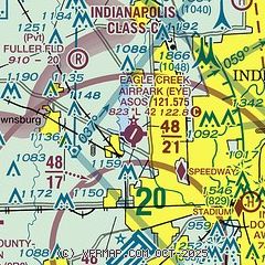
|
CAUTION: Diagram may not be current

| Airport distance calculator |
|---|
|
|
| Sunrise and sunset |
|---|
|
Times for 02-May-2026
| | Local
(UTC-4) | | Zulu
(UTC) |
|---|
| Morning civil twilight | | 06:16 | | 10:16 |
| Sunrise | | 06:45 | | 10:45 |
| Sunset | | 20:39 | | 00:39 |
| Evening civil twilight | | 21:08 | | 01:08 |
|
| Current date and time |
|---|
| Zulu (UTC) | 03-May-2026 01:04:06 |
|---|
| Local (UTC-4) | 02-May-2026 21:04:06 |
|---|
|
| METAR |
|---|
| KEYE | 030053Z AUTO 32003KT 10SM CLR 09/M03 A3007 RMK AO2 SLP185 T00941033
|
KIND
7nm S | 030054Z 31004KT 10SM FEW075 09/M04 A3007 RMK AO2 SLP185 T00891039
|
KTYQ
12nm N | 030055Z AUTO 00000KT 10SM CLR 09/M03 A3007 RMK AO2 T00851028
|
KUMP
13nm NE | 030055Z AUTO 32003KT 9SM CLR 08/M04 A3007 RMK AO2 T00841037 $
|
KHFY
15nm SE | 030055Z AUTO 00000KT 10SM CLR 08/M02 A3008 RMK AO2 T00761020
|
KMQJ
18nm E | 030055Z AUTO 32005KT 9SM FEW070 08/M04 A3007 RMK AO2 T00821040
|
|
| TAF |
|---|
KIND
7nm S | 022025Z 0220/0324 32010G20KT P6SM SCT060 FM030200 VRB03KT P6SM SKC FM031200 22007KT P6SM FEW250 FM031500 23012KT P6SM FEW220 FM031900 22014G23KT P6SM BKN090 FM032300 21011G19KT P6SM BKN100
|
|
| NOTAMs |
|---|
NOTAMs are issued by the DoD/FAA and will open in a separate window not controlled by AirNav.
|
|


