FAA INFORMATION EFFECTIVE 09 JULY 2026
Location
| FAA Identifier: | HFY |
| Lat/Long: | 39-37-39.4000N 086-05-16.9000W
39-37.656667N 086-05.281667W
39.6276111,-86.0880278
(estimated) |
| Elevation: | 822.1 ft. / 250.6 m (surveyed) |
| Variation: | 02W (1990) |
| From city: | 10 miles SE of INDIANAPOLIS, IN |
| Time zone: | UTC -4 (UTC -5 during Standard Time) |
| Zip code: | 46143 |
Airport Operations
| Airport use: | Open to the public |
| Activation date: | 09/1947 |
| Control tower: | no |
| ARTCC: | INDIANAPOLIS CENTER |
| FSS: | TERRE HAUTE FLIGHT SERVICE STATION |
| NOTAMs facility: | HUF (NOTAM-D service available) |
| Attendance: | MON-SAT 0700-1900, ALL SUN 0800-1700
AFT HR - 317-760-4047. |
| Pattern altitude: | 1622.1 ft. MSL |
| Wind indicator: | lighted |
| Segmented circle: | no |
| Lights: | ACTVT REIL RWY 01; MIRL RWY 01/19 - CTAF. |
| Beacon: | white-green (lighted land airport)
Operates sunset to sunrise. |
Airport Communications
| CTAF/UNICOM: | 123.0 |
| WX AWOS-3P: | 118.525 (317-882-5862) |
| INDIANAPOLIS APPROACH: | 124.95 |
| INDIANAPOLIS DEPARTURE: | 124.95 |
| CLANG RNAV STAR: | 128.175 |
| RACYR STAR: | 128.175 |
| WX AWOS-3 at 8A4 (9 nm N): | 135.525 (317-955-3160) |
| WX ASOS at IND (11 nm NW): | PHONE 317-220-6243 |
| WX ASOS at GEZ (13 nm E): | 121.55 (317-398-0246) |
| WX ASOS at EYE (15 nm NW): | 121.575 (317-329-1754) |
| WX AWOS-3PT at MQJ (16 nm NE): | 127.950 (317-335-3037) |
| WX AWOS-3PT at UMP (19 nm N): | 119.375 (317-842-3911) |
| WX AWOS-3PT at 2R2 (19 nm W): | 118.025 (317-718-4872) |
- APCH/DEP SVC PRVDD BY IND APCH ON 124.95.
Nearby radio navigation aids
| VOR radial/distance | | VOR name | | Freq | | Var |
|---|
| SHBr268/12.2 | | SHELBYVILLE VOR/DME | | 116.15 | | 01E |
| VHPr130/17.1 | | BRICKYARD VORTAC | | 116.30 | | 01E |
| OOMr042/37.9 | | HOOSIER VORTAC | | 110.20 | | 02W |
| NDB name | | Hdg/Dist | | Freq | | Var | | ID |
|---|
| NEW CASTLE | | 253/38.6 | | 385 | | 06W | | UWL | ..- .-- .-.. |
Airport Services
| Fuel available: | 100LL JET-A JET-A+ |
| Parking: | hangars and tiedowns |
| Airframe service: | MAJOR |
| Powerplant service: | MAJOR |
| Bottled oxygen: | HIGH/LOW |
| Bulk oxygen: | HIGH/LOW |
Runway Information
Runway 1/19
| Dimensions: | 5102 x 75 ft. / 1555 x 23 m |
| Surface: | asphalt/grooved, in excellent condition |
| Runway edge lights: | medium intensity |
| Operational restrictions: | 10 FT DITCH 125 FT R & L OF CNTRLN. |
| RUNWAY 1 | | RUNWAY 19 |
| Latitude: | 39-37.240030N | | 39-38.072923N |
| Longitude: | 086-05.353878W | | 086-05.209362W |
| Elevation: | 821.3 ft. | | 819.6 ft. |
| Traffic pattern: | left | | left |
| Runway heading: | 010 magnetic, 008 true | | 190 magnetic, 188 true |
| Displaced threshold: | 102 ft. | | 100 ft. |
| Markings: | nonprecision, in good condition | | nonprecision, in good condition |
| Visual slope indicator: | 4-light PAPI on left (3.00 degrees glide path) | | 4-light PAPI on left (3.00 degrees glide path) |
| Approach lights: | | | ODALS: omnidirectional approach lighting system |
| Runway end identifier lights: | yes | | no |
| Touchdown point: | yes, no lights | | yes, no lights |
| Obstructions: | 36 ft. tree, 1125 ft. from runway, 25:1 slope to clear
APCH RATIO 34:1 AT DTHR. | | 13 ft. road, 570 ft. from runway, 280 ft. right of centerline, 28:1 slope to clear
APCH RATIO 47:1 AT DTHR. |
Airport Ownership and Management from official FAA records
| Ownership: | Publicly-owned |
| Owner: | GREENWOOD BOAC
300 S. MADISON AVE
GREENWOOD, IN 46142
Phone 317-881-0887 |
| Manager: | RICK FERRILL
897 AIRPORT PKWY
GREENWOOD, IN 46143
Phone 317-881-0887 |
Additional Remarks
| - | STUDENT TRNG INVOF ARPT. |
| - | GCO AVBL ON FREQ 121.725 THRU INDIANAPOLIS CLNC AND FLIGHT SERVICES - TO ACTVT 4 SLOW CLICKS. IF UNAVBL CALL 317-227-5743. |
| - | SELF SVC FUEL H24. |
Instrument Procedures
NOTE: All procedures below are presented as PDF files. If you need a reader for these files, you should download the free Adobe Reader.NOT FOR NAVIGATION. Please procure official charts for flight.
FAA instrument procedures published for use from 09 July 2026 at 0901Z to 06 August 2026 at 0900Z.
STARs - Standard Terminal Arrivals |
|---|
| CLANG ONE (RNAV) **NEW** | |
download (138KB) |
| RACYR SIX **NEW** | |
download (203KB) |
IAPs - Instrument Approach Procedures |
|---|
| RNAV (GPS) RWY 01 | |
download (228KB) |
| RNAV (GPS) RWY 19 | |
download (234KB) |
| VOR-A | |
download (174KB) |
| NOTE: Special Alternate Minimums apply | |
download (168KB) |
Departure Procedures |
|---|
| DAWNN ONE | |
2 pages:
[1] [2] (280KB) |
| HOOSIER FIVE | |
download (205KB) |
| MAREO ONE (RNAV) | |
download (144KB) |
| MEARZ SEVEN | |
2 pages:
[1] [2] (266KB) |
| ROCKY ONE | |
download (217KB) |
| NOTE: Special Take-Off Minimums/Departure Procedures apply | |
download (271KB) |
Other nearby airports with instrument procedures:
KIND - Indianapolis International Airport (11 nm NW)
KGEZ - Shelbyville Municipal Airport (13 nm E)
KEYE - Eagle Creek Airpark (15 nm NW)
KMQJ - Indianapolis Regional Airport (16 nm NE)
KUMP - Indianapolis Metro Airport (19 nm N)
2R2 - Hendricks County Airport-Gordon Graham Field (19 nm W)
|
|

Road maps at:
MapQuest
Bing
Google
| Aerial photo |
|---|
WARNING: Photo may not be current or correct
 Photo by Mike Proctor
Photo taken 15-Jun-2007
Photo by Mike Proctor
Photo taken 15-Jun-2007
Do you have a better or more recent aerial photo of Indy South Greenwood Airport that you would like to share? If so, please send us your photo.
|
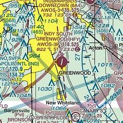
| Sectional chart |
|---|
|
CAUTION: Diagram may not be current

| Airport distance calculator |
|---|
|
|
| Sunrise and sunset |
|---|
|
Times for 24-Jul-2026
| | Local
(UTC-4) | | Zulu
(UTC) |
|---|
| Morning civil twilight | | 06:07 | | 10:07 |
| Sunrise | | 06:37 | | 10:37 |
| Sunset | | 21:04 | | 01:04 |
| Evening civil twilight | | 21:35 | | 01:35 |
|
| Current date and time |
|---|
| Zulu (UTC) | 25-Jul-2026 02:11:47 |
|---|
| Local (UTC-4) | 24-Jul-2026 22:11:47 |
|---|
|
| METAR |
|---|
| KHFY | 250155Z AUTO 04006KT 7SM SCT050 21/13 A3010 RMK AO2 T02070131
|
KIND
10nm NW | 250154Z 05007KT 10SM FEW050 BKN140 BKN250 22/13 A3009 RMK AO2 SLP186 T02220133
|
KGEZ
14nm E | 250153Z AUTO 02004KT 10SM CLR 21/16 A3009 RMK AO2 SLP183 T02060161
|
KMQJ
16nm NE | 250155Z AUTO 00000KT 10SM BKN140 19/17 A3010 RMK AO2 T01930173 $
|
KEYE
16nm NW | 250153Z AUTO 07004KT 10SM FEW050 21/13 A3009 RMK AO2 SLP184 T02110128
|
KUMP
19nm N | 250155Z AUTO 00000KT 10SM CLR 19/15 A3010 RMK AO2 T01920151 $
|
|
| TAF |
|---|
KIND
10nm NW | 242024Z 2420/2524 06005KT P6SM BKN050 FM250100 06004KT P6SM BKN100 FM251500 21006KT P6SM SCT050 OVC120
|
|
| NOTAMs |
|---|
NOTAMs are issued by the DoD/FAA and will open in a separate window not controlled by AirNav.
|
|


