FAA INFORMATION EFFECTIVE 14 MAY 2026
Location
| FAA Identifier: | GHM |
| Lat/Long: | 35-50-14.6970N 087-26-43.3570W
35-50.244950N 087-26.722617W
35.8374158,-87.4453769
(estimated) |
| Elevation: | 765 ft. / 233.2 m (surveyed) |
| Variation: | 03W (2020) |
| From city: | 3 miles N of CENTERVILLE, TN |
| Time zone: | UTC -5 (UTC -6 during Standard Time) |
| Zip code: | 37137 |
Airport Operations
| Airport use: | Open to the public |
| Activation date: | 05/1960 |
| Control tower: | no |
| ARTCC: | MEMPHIS CENTER |
| FSS: | JACKSON FLIGHT SERVICE STATION |
| NOTAMs facility: | MKL (NOTAM-D service available) |
| Attendance: | MON-FRI 0730-1600
AFT HR - 615-418-2164. |
| Wind indicator: | lighted |
| Segmented circle: | yes |
| Lights: | MIRL RWY 02/20 OPR DUSK-DAWN & PRESET LOW INTST; INCR INTST & ACTVT - CTAF. 0730-1600 ACTVT VGSI RWY 02 - CTAF. |
| Beacon: | white-green (lighted land airport)
Operates sunset to sunrise. |
Airport Communications
| CTAF/UNICOM: | 122.8 |
| NASHVILLE APPROACH: | 119.35 [0600-0000] |
| NASHVILLE DEPARTURE: | 119.35 [0600-0000] |
| WX AWOS-3 at M02 (17 nm N): | 123.875 (615-446-5481) |
Airport Services
| Fuel available: | 100LL JET-A+
100LL:FUEL AVBL H24 WITH CREDIT CARD. |
| Parking: | hangars and tiedowns |
Runway Information
Runway 2/20
| Dimensions: | 4002 x 75 ft. / 1220 x 23 m |
| Surface: | asphalt, in good condition |
| Weight bearing capacity: | | Single wheel: | 21.0 | | Double wheel: | 31.0 |
|
| Runway edge lights: | medium intensity |
| RUNWAY 2 | | RUNWAY 20 |
| Latitude: | 35-49.931585N | | 35-50.558327N |
| Longitude: | 087-26.848935W | | 087-26.596267W |
| Elevation: | 764.1 ft. | | 763.3 ft. |
| Traffic pattern: | left | | left |
| Runway heading: | 021 magnetic, 018 true | | 201 magnetic, 198 true |
| Displaced threshold: | no | | 239 ft. |
| Markings: | nonprecision, in good condition | | nonprecision, in good condition |
| Visual slope indicator: | 4-light PAPI on left (4.00 degrees glide path) | | 4-light PAPI on left (4.00 degrees glide path)
PAPI UNUSBL BYD 5 DEGS LEFT OF CNTRLN. |
| Runway end identifier lights: | yes | | yes |
| Touchdown point: | yes, no lights | | yes, no lights |
| Obstructions: | 72 ft. trees, 983 ft. from runway, 980 ft. right of centerline, 10:1 slope to clear | | 98 ft. tree, 1519 ft. from runway, 171 ft. right of centerline, 13:1 slope to clear |
Airport Ownership and Management from official FAA records
| Ownership: | Publicly-owned |
| Owner: | TOWN OF CENTERVILLE
102 EAST SWAN
CENTERVILLE, TN 37033
Phone 931-729-4246 |
| Manager: | WOODY WOODRUFF
2650 AIRPORT RD
CENTERVILLE, TN 37033
Phone 931-729-3032 |
Additional Remarks
| - | FOR CD CTC NASHVILLE APCH AT 615-695-4524. |
Instrument Procedures
NOTE: All procedures below are presented as PDF files. If you need a reader for these files, you should download the free Adobe Reader.NOT FOR NAVIGATION. Please procure official charts for flight.
FAA instrument procedures published for use from 14 May 2026 at 0901Z to 11 June 2026 at 0900Z.
IAPs - Instrument Approach Procedures |
|---|
| RNAV (GPS) RWY 02 | |
download (186KB) |
| RNAV (GPS) RWY 20 | |
download (207KB) |
| NOTE: Special Take-Off Minimums/Departure Procedures apply | |
download (193KB) |
Other nearby airports with instrument procedures:
M02 - Dickson Municipal Airport (17 nm N)
0M3 - Paul Bridges Field Airport (19 nm SW)
KMRC - Maury County Regional Airport (21 nm SE)
0M5 - Humphreys County Airport (22 nm NW)
KJWN - John C Tune Airport (34 nm NE)
|
|

Road maps at:
MapQuest
Bing
Google
| Aerial photo |
|---|
WARNING: Photo may not be current or correct
 Photo courtesy of Timeless Treasures
Photo taken 25-Aug-2013
looking north-northeast.
Photo courtesy of Timeless Treasures
Photo taken 25-Aug-2013
looking north-northeast.
Do you have a better or more recent aerial photo of Centerville Municipal Airport that you would like to share? If so, please send us your photo.
|
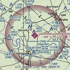
| Sectional chart |
|---|
|
| Airport distance calculator |
|---|
|
|
| Sunrise and sunset |
|---|
|
Times for 25-May-2026
| | Local
(UTC-5) | | Zulu
(UTC) |
|---|
| Morning civil twilight | | 05:10 | | 10:10 |
| Sunrise | | 05:39 | | 10:39 |
| Sunset | | 19:55 | | 00:55 |
| Evening civil twilight | | 20:24 | | 01:24 |
|
| Current date and time |
|---|
| Zulu (UTC) | 25-May-2026 19:02:46 |
|---|
| Local (UTC-5) | 25-May-2026 14:02:46 |
|---|
|
| METAR |
|---|
KM02
17nm N | 251835Z AUTO VRB04KT 10SM SCT019 BKN033 BKN040 25/20 A3004 RMK A01
|
KMRC
21nm SE | 251830Z AUTO 09005KT 10SM SCT013 BKN018 BKN023 25/25 A3003 RMK A01
|
KJWN
34nm NE | 251850Z 20006KT 10SM BKN021 BKN027 25/21 A3003
|
|
| NOTAMs |
|---|
NOTAMs are issued by the DoD/FAA and will open in a separate window not controlled by AirNav.
|
|

