FAA INFORMATION EFFECTIVE 19 FEBRUARY 2026
Location
| FAA Identifier: | HSR |
| Lat/Long: | 43-22-05.9000N 103-23-17.8000W
43-22.098333N 103-23.296667W
43.3683056,-103.3882778
(estimated) |
| Elevation: | 3150.2 ft. / 960.2 m (surveyed) |
| Variation: | 10E (2000) |
| From city: | 5 miles SE of HOT SPRINGS, SD |
| Time zone: | UTC -7 (UTC -6 during Daylight Saving Time) |
| Zip code: | 57766 |
Airport Operations
| Airport use: | Open to the public |
| Activation date: | 12/1950 |
| Control tower: | no |
| ARTCC: | DENVER CENTER |
| FSS: | HURON FLIGHT SERVICE STATION |
| NOTAMs facility: | HON (NOTAM-D service available) |
| Attendance: | MON-FRI 0800-1700 |
| Wind indicator: | lighted |
| Segmented circle: | yes |
| Lights: | ACTVT PAPI RWY 01 & 19; MIRL RWY 01/19 - CTAF. |
| Beacon: | white-green (lighted land airport)
Operates sunset to sunrise. |
Airport Communications
- AUTOMATED UNICOM; 3 CLICKS ADZY & WX.
- APCH/DEP CTL SVC PRVDD BY DENVER ARTCC (ZDV) ON FREQS 127.95/338.2 (RAPID CITY RCAG).
Nearby radio navigation aids
| VOR radial/distance | | VOR name | | Freq | | Var |
|---|
| RAPr191/39.9 | | RAPID CITY VORTAC | | 112.30 | | 13E |
| NDB name | | Hdg/Dist | | Freq | | Var | | ID |
|---|
| WHITNEY | | 331/34.8 | | 275 | | 07E | | HIN | .... .. -. |
Airport Services
| Fuel available: | 100LL
100LL:FUEL AVBL 24 HRS WITH CREDIT CARD. |
| Parking: | hangars and tiedowns |
| Airframe service: | MAJOR |
| Powerplant service: | MAJOR |
| Bottled oxygen: | NONE |
| Bulk oxygen: | NONE |
Runway Information
Runway 1/19
| Dimensions: | 4506 x 100 ft. / 1373 x 30 m |
| Surface: | asphalt, in good condition |
| Weight bearing capacity: | |
| Runway edge lights: | medium intensity |
| RUNWAY 1 | | RUNWAY 19 |
| Latitude: | 43-21.804853N | | 43-22.494213N |
| Longitude: | 103-23.541855W | | 103-23.167195W |
| Elevation: | 3150.2 ft. | | 3141.8 ft. |
| Traffic pattern: | left | | left |
| Runway heading: | 012 magnetic, 022 true | | 192 magnetic, 202 true |
| Markings: | nonprecision, in good condition | | nonprecision, in good condition |
| Visual slope indicator: | 2-light PAPI on left (3.00 degrees glide path) | | 2-light PAPI on left (3.00 degrees glide path) |
| Runway end identifier lights: | no | | no |
| Touchdown point: | yes, no lights | | yes, no lights |
| Obstructions: | 122 ft. trees, 3400 ft. from runway, 26:1 slope to clear | | 20 ft. tree, 601 ft. from runway, 280 ft. left of centerline, 20:1 slope to clear |
Runway 6/24
| Dimensions: | 3926 x 235 ft. / 1197 x 72 m |
| Surface: | turf, in good condition |
| RUNWAY 6 | | RUNWAY 24 |
| Latitude: | 43-21.962662N | | 43-22.119542N |
| Longitude: | 103-23.661407W | | 103-22.802210W |
| Elevation: | 3146.2 ft. | | 3142.0 ft. |
| Traffic pattern: | left | | left |
| Runway heading: | 066 magnetic, 076 true | | 246 magnetic, 256 true |
| Markings: | NSTD, in good condition | | NSTD, in good condition |
| Runway end identifier lights: | no | | no |
| Touchdown point: | yes, no lights | | yes, no lights |
Airport Ownership and Management from official FAA records
| Ownership: | Publicly-owned |
| Owner: | CITY OF HOT SPRINGS
BOX 391
HOT SPRINGS, SD 57747
Phone 605-745-3135 |
| Manager: | IVAN VENNER
27858 HWY 385
HOT SPRINGS, SD 57747
Phone 605-295-1535 |
Additional Remarks
| - | RY 01 +21 FT PLINE 680 FT FM THR. |
| - | BIRDS ON & INVOF ARPT. |
| - | RY 06/24 MARKED WITH BLACK AND WHITE CONES. |
| - | GLIDER OPS ON & INVOF ARPT. |
| - | GCO AVBL ON FREQ 121.725 ( 4 CLICKS TO DENVER CENTER AND 6 CLIKCS TO FLIGHT SERVICES) |
| - | COMPASS ROSE LCTD ON APRON. |
| - | FOR CD IF UNA VIA GCO CTC DENVER ARTCC AT 303-651-4257. |
| - | HIGH VOL OF ACFT OPRNG INVOF OF MT RUSHMORE AND CRAZY HORSE MONUMENTS AT OR BLW 7500 FT; PILOTS ARE ADVISED TO MNT 122.85 FOR TFC ADVISORIES. |
Instrument Procedures
NOTE: All procedures below are presented as PDF files. If you need a reader for these files, you should download the free Adobe Reader.NOT FOR NAVIGATION. Please procure official charts for flight.
FAA instrument procedures published for use from 19 February 2026 at 0901Z to 19 March 2026 at 0900Z.
IAPs - Instrument Approach Procedures |
|---|
| RNAV (GPS) RWY 01 | |
download (223KB) |
| RNAV (GPS) RWY 19 | |
download (224KB) |
Departure Procedures |
|---|
| HOT SPRINGS TWO | |
download (136KB) |
| TOADSTOOL TWO | |
download (142KB) |
| NOTE: Special Take-Off Minimums/Departure Procedures apply | |
download (156KB) |
Other nearby airports with instrument procedures:
KCDR - Chadron Municipal Airport (34 nm S)
KRAP - Rapid City Regional Airport (43 nm N)
KIEN - Pine Ridge Airport (44 nm SE)
KRCA - Ellsworth Air Force Base (48 nm N)
KECS - Mondell Field Airport (51 nm NW)
|
|

Road maps at:
MapQuest
Bing
Google
| Aerial photo |
|---|
WARNING: Photo may not be current or correct
 Photo by Andreas Lauschke
Photo taken 06-Oct-2024
looking south.
Photo by Andreas Lauschke
Photo taken 06-Oct-2024
looking south.
Do you have a better or more recent aerial photo of Hot Springs Municipal Airport that you would like to share? If so, please send us your photo.
|
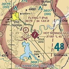
| Sectional chart |
|---|
|
| Airport distance calculator |
|---|
|
|
| Sunrise and sunset |
|---|
|
Times for 10-Mar-2026
| | Local
(UTC-6) | | Zulu
(UTC) |
|---|
| Morning civil twilight | | 06:47 | | 12:47 |
| Sunrise | | 07:15 | | 13:15 |
| Sunset | | 18:52 | | 00:52 |
| Evening civil twilight | | 19:21 | | 01:21 |
|
| Current date and time |
|---|
| Zulu (UTC) | 10-Mar-2026 17:45:09 |
|---|
| Local (UTC-6) | 10-Mar-2026 11:45:09 |
|---|
|
| TAF |
|---|
KCDR
34nm S | 101123Z 1012/1112 VRB06KT P6SM BKN015 PROB30 1012/1015 6SM -SHRA OVC010 FM101900 VRB06KT P6SM SCT060 FM102200 02008KT P6SM VCSH SCT060
|
|
| NOTAMs |
|---|
NOTAMs are issued by the DoD/FAA and will open in a separate window not controlled by AirNav.
|
|

