FAA INFORMATION EFFECTIVE 14 MAY 2026
Location
| FAA Identifier: | JFX |
| Lat/Long: | 33-54-07.2000N 087-18-49.8000W
33-54.120000N 087-18.830000W
33.9020000,-87.3138333
(estimated) |
| Elevation: | 482.6 ft. / 147.1 m (surveyed) |
| Variation: | 01W (1995) |
| From city: | 5 miles NW of JASPER, AL |
| Time zone: | UTC -5 (UTC -6 during Standard Time) |
| Zip code: | 35503 |
Airport Operations
| Airport use: | Open to the public |
| Control tower: | no |
| ARTCC: | ATLANTA CENTER |
| FSS: | ANNISTON FLIGHT SERVICE STATION |
| NOTAMs facility: | ANB (NOTAM-D service available) |
| Attendance: | MON - SAT 0700-2000 |
| Wind indicator: | lighted |
| Segmented circle: | yes |
| Lights: | ACTVT REIL RWY 9 & 27; VASI RWY 9 & 27; MIRL RWY 9/27- CTAF. |
| Beacon: | white-green (lighted land airport)
Operates sunset to sunrise. |
Airport Communications
| CTAF/UNICOM: | 123.075 |
| WX AWOS-3PT: | 119.225 (205-295-5539) |
| BIRMINGHAM APPROACH: | 127.675 [0600-0000] |
| BIRMINGHAM DEPARTURE: | 127.675 [0600-0000] |
| CLEARANCE DELIVERY: | 121.725 |
Nearby radio navigation aids
| VOR radial/distance | | VOR name | | Freq | | Var |
|---|
| VUZr302/24.9 | | VULCAN VORTAC | | 114.40 | | 02E |
| OKWr355/40.0 | | BROOKWOOD VORTAC | | 111.00 | | 00E |
Airport Services
| Fuel available: | 100LL JET-A JET-A1
100LL:FUEL AVBL 24/7 WITH CC. |
| Parking: | tiedowns |
| Airframe service: | MAJOR
NO OUTSIDE WORK EXCP EMERGS. |
| Powerplant service: | MAJOR
NO OUTSIDE WORK EXCP EMERGS. |
| Bottled oxygen: | NONE |
| Bulk oxygen: | NONE |
Runway Information
Runway 9/27
| Dimensions: | 5004 x 100 ft. / 1525 x 30 m |
| Surface: | asphalt, in fair condition |
| Weight bearing capacity: | |
| Runway edge lights: | medium intensity |
| RUNWAY 9 | | RUNWAY 27 |
| Latitude: | 33-54.132552N | | 33-54.105750N |
| Longitude: | 087-19.324725W | | 087-18.335835W |
| Elevation: | 482.3 ft. | | 473.8 ft. |
| Traffic pattern: | left | | left |
| Runway heading: | 093 magnetic, 092 true | | 273 magnetic, 272 true |
| Displaced threshold: | no | | 190 ft. |
| Declared distances: | TORA:5001 TODA:5001 ASDA:4800 LDA:4800 | | TORA:5001 TODA:5001 ASDA:5001 LDA:4800 |
| Markings: | nonprecision, in fair condition | | precision, in fair condition |
| Visual slope indicator: | 4-box VASI on left (3.00 degrees glide path) | | 4-box VASI on left (3.00 degrees glide path) |
| Runway end identifier lights: | yes | | yes |
| Touchdown point: | yes, no lights | | yes, no lights |
| Instrument approach: | | | ILS/DME |
| Obstructions: | 11 ft. trees, 230 ft. from runway, 202 ft. left of centerline, 2:1 slope to clear | | 21 ft. trees, 705 ft. from runway, 64 ft. right of centerline, 24:1 slope to clear |
Airport Ownership and Management from official FAA records
| Ownership: | Publicly-owned |
| Owner: | WALKER COUNTY COMMISSION
1801 3RD AVE. S., SUITE 113
JASPER, AL 35501
Phone 205-384-7230
STEVE MILLER, CHAIRMAN. MIKE SHORT, CO ENGR, KEITH DUNCAN, ARPT MGR. |
| Manager: | KEITH DUNCAN
198 BIDDLE DRIVE
JASPER, AL 35503
Phone 205-388-1294 |
Additional Remarks
| - | DEER ON & INVOF RWYS. |
| - | GCO AVBL ON FREQ 121.725 THRU BIRMINGHAM (BHM) CLEARANCE DELIVERY. |
| - | FOR CD IF UNA VIA GCO CTC BIRMINGHAM APCH AT 205-769-3890. |
| - | HVY FLT STUDENT ACT. |
Instrument Procedures
NOTE: All procedures below are presented as PDF files. If you need a reader for these files, you should download the free Adobe Reader.NOT FOR NAVIGATION. Please procure official charts for flight.
FAA instrument procedures published for use from 14 May 2026 at 0901Z to 11 June 2026 at 0900Z.
IAPs - Instrument Approach Procedures |
|---|
| ILS OR LOC RWY 27 | |
download (266KB) |
| RNAV (GPS) RWY 09 | |
download (252KB) |
| RNAV (GPS) RWY 27 | |
download (268KB) |
| VOR/DME-A | |
download (188KB) |
| NOTE: Special Alternate Minimums apply | |
download (159KB) |
| NOTE: Special Take-Off Minimums/Departure Procedures apply | |
download (517KB) |
Other nearby airports with instrument procedures:
1M4 - Posey Field Airport (27 nm NW)
M95 - Richard Arthur Field Airport (28 nm SW)
KCMD - Cullman Regional Airport/Folsom Field (32 nm NE)
KBHM - Birmingham-Shuttlesworth International Airport (35 nm SE)
5M0 - Hartselle/Morgan County Regional Airport (36 nm NE)
|
|

Road maps at:
MapQuest
Bing
Google
| Aerial photo |
|---|
WARNING: Photo may not be current or correct
 Photo by Berry Meyer
© AlabamaAviator.com
Photo taken 14-Jan-2007
Do you have a better or more recent aerial photo of Walker County Airport/Bevill Field that you would like to share? If so, please send us your photo.
|
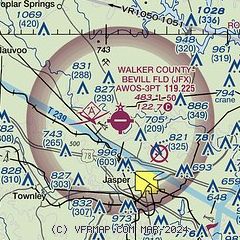
| Sectional chart |
|---|
|
CAUTION: Diagram may not be current

| Airport distance calculator |
|---|
|
|
| Sunrise and sunset |
|---|
|
Times for 19-May-2026
| | Local
(UTC-5) | | Zulu
(UTC) |
|---|
| Morning civil twilight | | 05:18 | | 10:18 |
| Sunrise | | 05:46 | | 10:46 |
| Sunset | | 19:45 | | 00:45 |
| Evening civil twilight | | 20:13 | | 01:13 |
|
| Current date and time |
|---|
| Zulu (UTC) | 19-May-2026 06:46:32 |
|---|
| Local (UTC-5) | 19-May-2026 01:46:32 |
|---|
|
| METAR |
|---|
| KJFX | 190615Z AUTO 00000KT 10SM CLR 21/21 A3015 RMK AO2
|
|
| TAF |
|---|
KBHM
35nm SE | 190532Z 1906/2006 VRB03KT P6SM BKN250 FM191500 17008KT P6SM BKN250 FM200100 VRB03KT P6SM BKN250
|
|
| NOTAMs |
|---|
NOTAMs are issued by the DoD/FAA and will open in a separate window not controlled by AirNav.
|
|


