FAA INFORMATION EFFECTIVE 11 JUNE 2026
Location
| FAA Identifier: | M95 |
| Lat/Long: | 33-42-32.7810N 087-48-54.7510W
33-42.546350N 087-48.912517W
33.7091058,-87.8152086
(estimated) |
| Elevation: | 357.4 ft. / 108.9 m (surveyed) |
| Variation: | 03W (2020) |
| From city: | 3 miles NE of FAYETTE, AL |
| Time zone: | UTC -5 (UTC -6 during Standard Time) |
| Zip code: | 35555 |
Airport Operations
| Airport use: | Open to the public |
| Activation date: | 10/1946 |
| Control tower: | no |
| ARTCC: | MEMPHIS CENTER |
| FSS: | ANNISTON FLIGHT SERVICE STATION |
| NOTAMs facility: | ANB (NOTAM-D service available) |
| Attendance: | MON-FRI 0900-1300 |
| Wind indicator: | lighted |
| Segmented circle: | yes |
| Lights: | ACTVT MIRL RWY 01/19; TWY LGTS - CTAF. PAPI RWY 01 & 19 OPR CONSLY. |
| Beacon: | white-green (lighted land airport)
Operates sunset to sunrise. |
Airport Communications
| CTAF/UNICOM: | 122.8 |
| COLUMBUS APPROACH: | 126.075 |
| COLUMBUS DEPARTURE: | 126.075 |
- APCH/DEP SVC PRVDD BY MEMPHIS ARTCC ON FREQS 127.1/269.4 (COLUMBUS RCAG) WHEN COLUMBUS APCH CTL CLSD.
Nearby radio navigation aids
| VOR radial/distance | | VOR name | | Freq | | Var |
|---|
| CBMr083/31.4 | | CALEDONIA VORTAC | | 115.20 | | 00E |
| IGBr065/37.4 | | BIGBEE VORTAC | | 116.20 | | 04E |
Airport Services
| Fuel available: | 100LL JET-A+ |
| Parking: | tiedowns |
| Bottled oxygen: | NONE |
| Bulk oxygen: | NONE |
Runway Information
Runway 1/19
| Dimensions: | 5009 x 80 ft. / 1527 x 24 m |
| Surface: | asphalt/grooved, in fair condition |
| Weight bearing capacity: | | PCN 10 /F/C/X/T | | Single wheel: | 15.0 |
|
| Runway edge lights: | medium intensity |
| Runway edge markings: | IDENT, CL AND TRSHLD MKINGS SEVERELY FADED |
| RUNWAY 1 | | RUNWAY 19 |
| Latitude: | 33-42.133813N | | 33-42.958893N |
| Longitude: | 087-48.934883W | | 087-48.890157W |
| Elevation: | 330.9 ft. | | 357.4 ft. |
| Traffic pattern: | left | | left |
| Runway heading: | 006 magnetic, 003 true | | 186 magnetic, 183 true |
| Markings: | nonprecision, in poor condition | | nonprecision, in poor condition |
| Visual slope indicator: | 2-light PAPI on left (3.00 degrees glide path) | | 2-light PAPI on left (3.00 degrees glide path) |
| Touchdown point: | yes, no lights | | yes, no lights |
| Obstructions: | 63 ft. trees, 402 ft. from runway, 273 ft. left of centerline, 3:1 slope to clear | | 36 ft. trees, 441 ft. from runway, 221 ft. left of centerline, 6:1 slope to clear |
Airport Ownership and Management from official FAA records
| Ownership: | Publicly-owned |
| Owner: | CITY OF FAYETTE
203 TEMPLE AVE NORTH
FAYETTE, AL 35555
Phone 205-932-5367 |
| Manager: | KIP MADISON
100 21ST STREET NORTH EAST
FAYETTE, AL 35555
Phone 205-932-3819 |
Additional Remarks
| - | TWY LGTS FOR TWY TURNOFF ONLY. |
| - | DEER ON & INVOF ARPT. |
| - | FOR CD CTC COLUMBUS APCH AT 662-434-3044. |
Instrument Procedures
NOTE: All procedures below are presented as PDF files. If you need a reader for these files, you should download the free Adobe Reader.NOT FOR NAVIGATION. Please procure official charts for flight.
FAA instrument procedures published for use from 11 June 2026 at 0901Z to 09 July 2026 at 0900z.
IAPs - Instrument Approach Procedures |
|---|
| RNAV (GPS) RWY 01 | |
download (219KB) |
| RNAV (GPS) RWY 19 | |
download (183KB) |
| NOTE: Special Take-Off Minimums/Departure Procedures apply | |
download (481KB) |
Other nearby airports with instrument procedures:
M55 - Lamar County Airport (17 nm NW)
3M8 - North Pickens Airport (22 nm SW)
KHAB - Marion County-Rankin Fite Airport (26 nm N)
KJFX - Walker County Airport/Bevill Field (28 nm NE)
KTCL - Tuscaloosa National Airport (31 nm S)
|
|

Road maps at:
MapQuest
Bing
Google
| Aerial photo |
|---|
WARNING: Photo may not be current or correct
 Taken late October 2007
Do you have a better or more recent aerial photo of Richard Arthur Field Airport that you would like to share? If so, please send us your photo.
|
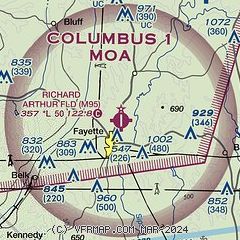
| Sectional chart |
|---|
|
| Airport distance calculator |
|---|
|
|
| Sunrise and sunset |
|---|
|
Times for 19-Jun-2026
| | Local
(UTC-5) | | Zulu
(UTC) |
|---|
| Morning civil twilight | | 05:13 | | 10:13 |
| Sunrise | | 05:42 | | 10:42 |
| Sunset | | 20:03 | | 01:03 |
| Evening civil twilight | | 20:32 | | 01:32 |
|
| Current date and time |
|---|
| Zulu (UTC) | 19-Jun-2026 08:27:55 |
|---|
| Local (UTC-5) | 19-Jun-2026 03:27:55 |
|---|
|
| METAR |
|---|
KJFX
28nm NE | 190815Z AUTO 00000KT OVC003 23/23 A2993 RMK AO2 PWINO
|
KTCL
31nm S | 190806Z AUTO 00000KT 1 3/4SM BR OVC002 23/23 A2991 RMK AO2 T02330233 $
|
KCBM
32nm W | 190817Z AUTO 00000KT 10SM OVC032 24/24 A2986 RMK AO2 RAE0755RAB02E17 SLP112 $
|
KM40
35nm W | 190815Z AUTO 00000KT 8SM BKN029 23/23 A2991 RMK AO2
|
K1M4
36nm N | 190819Z AUTO 20003KT 3SM BR OVC003 22/22 A2994 RMK AO2
|
KGTR
41nm W | 190817Z AUTO 17003KT 1/2SM FG BKN002 23/23 A2991 RMK AO2 CIG 002V005 RVRNO $
|
|
| TAF |
|---|
KTCL
31nm S | 190539Z 1906/2006 18004KT P6SM OVC007 FM190900 26005KT P6SM VCSH OVC005 FM191400 VRB03KT P6SM BKN007 FM191700 00000KT P6SM VCSH SCT022 BKN030 FM192000 VRB03KT P6SM BKN045 PROB30 1920/1924 4SM TSRA OVC035CB FM200000 00000KT P6SM BKN070 PROB30 2000/2006 4SM TSRA OVC035CB
|
KCBM
32nm W | 181950Z 1819/1923 17012G18KT 9999 OVC015 QNH2973INS BECMG 1819/1820 21009KT 9999 BKN020 QNH2972INS BECMG 1904/1905 27006KT 9999 BKN015 OVC030 QNH2979INS BECMG 1910/1911 VRB06KT 9999 BKN007 OVC015 QNH2986INS BECMG 1915/1916 31009KT 8000 -SHRA VCTS BKN010CB OVC020 QNH2990INS TEMPO 1917/1919 29012G20KT 4800 -TSRA OVC010CB BECMG 1918/1919 31009KT 9999 NSW BKN015 QNH2992INS TX25/1819Z TN21/1909Z LAST NO AMDS AFT 1819 NEXT 2209
|
|
| NOTAMs |
|---|
NOTAMs are issued by the DoD/FAA and will open in a separate window not controlled by AirNav.
|
|

