FAA INFORMATION EFFECTIVE 19 MARCH 2026
Location
| FAA Identifier: | MGE |
| Lat/Long: | 33-54-51.9900N 084-30-51.2900W
33-54.866500N 084-30.854833W
33.9144417,-84.5142472
(estimated) |
| Elevation: | 1068.5 ft. / 325.7 m (surveyed) |
| Variation: | 03W (2005) |
| From city: | 1 mile S of MARIETTA, GA |
| Time zone: | UTC -4 (UTC -5 during Standard Time) |
| Zip code: | 30060 |
Airport Operations
| Airport use: | Private use. Permission required prior to landing |
| Activation date: | 02/1944 |
| Control tower: | yes |
| ARTCC: | ATLANTA CENTER |
| FSS: | MACON FLIGHT SERVICE STATION |
| NOTAMs facility: | MGE (NOTAM-D service available) |
| Attendance: | CONTINUOUS
OPR 1300-0400Z++ MON-FRI, 1300-2100Z++ SAT SUN, CLSD FED HOL. |
| Pattern altitude: | TFC PAT: OVHD, ENTER INITIAL AT 3500 FT, DSND TO 2600 FT, LVL BRK AT RWY THR. |
| Wind indicator: | yes |
| Segmented circle: | no |
| Beacon: | white-green (lighted land airport)
Operates sunset to sunrise. |
| International operations: | customs landing rights airport |
Airport Communications
| ATIS: | 269.5 |
| DOBBINS GROUND: | 125.3 275.8 [1200-0400Z++] |
| DOBBINS TOWER: | 120.75 370.875 [1200-0400Z++] |
| ATLANTA APPROACH: | 121.0 |
| ATLANTA DEPARTURE: | 121.0 |
| ARNG OPS: | 34.4FM |
| BOKRT STAR: | 119.8 |
| COMD POST: | 322.9 ;94 AW |
| EMERG: | 121.5 243.0 |
| GCA: | 120.225 |
| NAF OPS: | 340.2 |
| PMSV METRO: | 274.75 342.5 344.6 |
| PTD: | 139.3 372.2 |
| WRGNZ STAR: | 128.575 |
| WX AWOS-3PT at RYY (7 nm NW): | PHONE 770-425-3406 |
| WX ASOS at FTY (8 nm S): | PHONE 404-696-5660 |
| WX ASOS at PDK (11 nm E): | 128.4 (770-457-1691) |
| WX ASOS at ATL (17 nm S): | PHONE 404-559-5166 |
- GCA SVCS UNAVBL ON NON-UNIT TRNG WKEND.
- CALL DAPPER DAN.
- FULL SVC AVBL 1100-0400Z++, DSN 625-5190. OT CTC 26TH OWS DSN 331-2651, COMM 318-529-2604. 274.75.
Nearby radio navigation aids
| VOR radial/distance | | VOR name | | Freq | | Var |
|---|
| RMGr115/33.6 | | ROME VORTAC | | 115.40 | | 01E |
| NDB name | | Hdg/Dist | | Freq | | Var | | ID |
|---|
| PECAT | | 003/36.8 | | 316 | | 05W | | FFC | ..-. ..-. -.-. |
| CARROLLTON | | 060/37.2 | | 278 | | 04W | | GPQ | --. .--. --.- |
Airport Services
| Fuel available: | 100LL JET-A++ |
| Airframe service: | MAJOR |
| Powerplant service: | MAJOR |
| Bottled oxygen: | NONE |
| Bulk oxygen: | HIGH/LOW |
Runway Information
Runway 11/29
| Dimensions: | 10002 x 300 ft. / 3049 x 91 m |
| Surface: | concrete |
| Weight bearing capacity: | |
| Runway edge lights: | high intensity |
| RUNWAY 11 | | RUNWAY 29 |
| Latitude: | 33-55.147310N | | 33-54.686367N |
| Longitude: | 084-31.930787W | | 084-30.031703W |
| Elevation: | 1068.5 ft. | | 989.6 ft. |
| Traffic pattern: | left | | left |
| Runway heading: | 109 magnetic, 106 true | | 289 magnetic, 286 true |
| Markings: | , in good condition | | , in good condition |
| Visual slope indicator: | 4-light PAPI on left (3.00 degrees glide path) | | 4-light PAPI on left (3.00 degrees glide path) |
| RVR equipment: | touchdown | | touchdown |
| Approach lights: | ALSF1: standard 2,400 foot high intensity approach lighting system with centerline sequenced flashers (category I) | | SALSF |
| Runway end identifier lights: | yes | | yes |
| Touchdown point: | yes, no lights | | yes, no lights |
| Instrument approach: | LOC/GS | | LOC/GS |
Runway 110/290
| Dimensions: | 3495 x 60 ft. / 1065 x 18 m |
| Surface: | concrete |
| Weight bearing capacity: | |
| Runway edge lights: | high intensity |
| RUNWAY 110 | | RUNWAY 290 |
| Latitude: | 33-54.803167N | | 33-54.642167N |
| Longitude: | 084-30.824833W | | 084-30.161167W |
| Elevation: | 1019.1 ft. | | 989.8 ft. |
| Traffic pattern: | left | | left |
| Runway heading: | 109 magnetic, 106 true | | 289 magnetic, 286 true |
Airport Ownership and Management from official FAA records
| Ownership: | U.S. Air Force |
| Owner: | USAF
DOBBINS AFB
MARIETTA, GA 30060 |
| Manager: | CHIEF OF AFLD MANAGEMENT
DOBBINS AFB
MARIETTA, GA 30060 |
Additional Remarks
| - | LGT: FOR OLS RWY 11-29 LCTN DATA SEE FLIP AP/1 SUPPLEMENTARY ARPT RMK. |
| - | JASU: 1(A/MA32A-86) 2(AM32-95) 3(A/M32A-86), 5(ESSEX B809). BASE ASGN ACFT HAVE PRIORITY. |
| - | FUEL: OPR 1100-0500Z++ MON-THU; 1100-0200Z++ FRI; 1300-2100Z++ SAT-SUN, EXP 1 HR FUEL DELAY, CLSD FED HOL. A++100. LHNIT. |
| - | OIL: O-148-156 SOAP/JOAP, NO LAB SVC. |
| - | TRAN ALERT: OPR 1300-0400Z++ MON-FRI, 1300-2100Z++ SAT-SUN, CLSD FED HOL. LAVATORY SVC RQR 24 HR PN. DE ICE SVC ON TRANS RAMP AND C130 RAMP ONLY WITH 24 HR PN. |
| - | ACFT-AIRCREWS DESIRING TO VISIT THE GEORGIA ARNG OR AASF#2, MUST LAND/PARK AT CLAY NG RAMP, 24 HR PPR REQ, CTC DSN 753-3500, C678-569-3500. SVC LMTD TSNT PRKG AVBL. |
| - | RSTD: PPR CTC AMOPS AT DSN 625-4903, C678-655-4903. ACFT RSTD DUR BIRD WATCH COND MODERATE (TKOF/LDG PERMS WHEN DEP/ARR RTE AVOID IDENT BIRD ACT, NO LCL IFR/VFR TFC PAT ACFT) AND SEVERE (TKOF/LDG PROH WO 94TH OG/CC APVL), CTC AMOPS FOR CURRENT BIRD WATCH COND. |
| - | RSTD: HAZ CARGO RSTD TO C130 OR SMALLER ACFT. DO NOT TRANS ON HF WO TWR APVL. CTC AMOPS 20 MIN PRIOR TO LDG TO CONFIRM PPR AND SVCG/LOAD. TO PRK AF SIDE PPR, DSN 625-4903. ASSAULT LDG ZONE LCL USE ONLY. |
| - | MISC: WINDS ARE EST DUE TO FMQ-13 WIND SENSORS BEING ACCURATE TO WITHIN ONLY +/-4 KT. ATC/WX WILL NOT INCL/RELAY WIND CORR INTO FCST/PHRASEOLOGY. THEREFORE, AIRCREWS WILL INCORPORATE A +/- 4 KT ACCURACY INTO THEIR DECISION MAKING PROCESS FOR FLYING OPR. |
| - | MISC: RSRS APPLIED TO BASE ASGN ACFT ONLY; STD USAF RSRS NOT APPLICABLE. |
| - | MISC: AFLD MGMT EMAIL 94OGOPS@US.AF.MIL. |
| - | RADAR: SEE TERMINAL FLIP FOR RADAR MINIMA. |
| - | MISC: RWY 29 NON-STD APCH LIGHTS. |
| - | MISC: RWY 11/29 AND VEDA ALZ CLSD LAST SAT EACH MONTH FOR MAINT, 1300-2100Z++. |
| - | RSTD: PPR ONLY COORD/ISSUED 30 DAYS IN ADVANCE. |
| - | MISC: AFLD MGMT AND COMD POST DO NOT ISSUE OR STORE COMSEC. FOR STORAGE OF SMALL NON-COMSEC CLASSIFIED, 24 HOUR PN RQR, CTC COMD POST AT DSN 625-5106, C678-655-5106, MON-FRI, 1100-1500Z++, SAT-SUN, UNIT TRNG WKEND ONLY 1100-2000Z++. |
| - | RSTD: LOCKHEED MARTIN PPR FOR USE OF PRKG RAMPS OR FAC, C800-825-6083. |
| - | PMSV METRO: AWOS IN USE; AUGMENTED DUR AFLD OPR HRS. |
| - | RSTD: HOT CARGO PAD RQR 48 HR PN FOR USE. |
| - | FOR CD WHEN ATCT CLSD, CTC ATLANTA APCH AT 678-364-6132. |
| - | FLUID: LHNIT (LOW AND HI PRES NITROGEN SVCG). DE ICE (ANTI ICG/DE ICG/DEFRSTG FLUID (MIL-A-8243). |
| - | MISC: USE EXTREME CTN FOR SUAS OPERATING AT OR BLW 400FT AGL IN CLASS D. |
Instrument Procedures
NOTE: All procedures below are presented as PDF files. If you need a reader for these files, you should download the free Adobe Reader.NOT FOR NAVIGATION. Please procure official charts for flight.
FAA instrument procedures published for use from 19 March 2026 at 0901Z to 16 April 2026 at 0900Z.
STARs - Standard Terminal Arrivals |
|---|
| BOKRT THREE (RNAV) | |
download (186KB) |
| BUKHD THREE (RNAV) | |
download (190KB) |
| DEHAN THREE (RNAV) | |
2 pages:
[1] [2] (326KB) |
| SWTEE TWO (RNAV) | |
download (142KB) |
| WRGNZ THREE (RNAV) | |
download (245KB) |
IAPs - Instrument Approach Procedures |
|---|
| ILS OR LOC RWY 11 | |
download (135KB) |
| ILS OR LOC RWY 29 | |
download (147KB) |
| RNAV (GPS) RWY 11 | |
download (71KB) |
| RNAV (GPS) RWY 29 | |
download (80KB) |
| TACAN RWY 11 | |
download (122KB) |
| TACAN RWY 29 | |
download (125KB) |
| Radar Approach Procedures available **CHANGED** | |
download (152KB) |
| NOTE: Special Take-Off Minimums/Departure Procedures apply | |
download (508KB) |
Other nearby airports with instrument procedures:
KRYY - Cobb County International Airport-McCollum Field (7 nm NW)
KFTY - Fulton County Executive Airport/Charlie Brown Field (8 nm S)
KPDK - Dekalb-Peachtree Airport (11 nm E)
KATL - Hartsfield/Jackson Atlanta International Airport (17 nm S)
KVPC - Cartersville Airport (21 nm NW)
|
|

Road maps at:
MapQuest
Bing
Google
| Aerial photo |
|---|
WARNING: Photo may not be current or correct
 Photo courtesy of AirNav, LLC
Photo taken 26-Nov-2017
looking northwest.
Photo courtesy of AirNav, LLC
Photo taken 26-Nov-2017
looking northwest.
Do you have a better or more recent aerial photo of Dobbins ARB Airport that you would like to share? If so, please send us your photo.
|
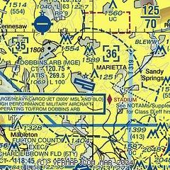
| Sectional chart |
|---|
|
 Download PDF
of official airport diagram from the FAA
| Airport distance calculator |
|---|
|
|
| Sunrise and sunset |
|---|
|
Times for 07-Apr-2026
| | Local
(UTC-4) | | Zulu
(UTC) |
|---|
| Morning civil twilight | | 06:53 | | 10:53 |
| Sunrise | | 07:19 | | 11:19 |
| Sunset | | 20:02 | | 00:02 |
| Evening civil twilight | | 20:27 | | 00:27 |
|
| Current date and time |
|---|
| Zulu (UTC) | 07-Apr-2026 12:53:02 |
|---|
| Local (UTC-4) | 07-Apr-2026 08:53:02 |
|---|
|
| METAR |
|---|
KRYY
7nm NW | 071150Z 00000KT 10SM CLR 10/03 A3021 RMK AO2 SLP962 T01000028 10133 20072 53009 $
|
KFTY
8nm S | 071153Z 00000KT 10SM CLR 07/04 A3019 RMK AO2 SLP222 T00670039 10094 20061 53011
|
KPDK
11nm E | 071153Z 00000KT 10SM CLR 09/03 A3019 RMK AO2 SLP221 T00890033 10122 20089 53011
|
KATL
17nm S | 071152Z 01007KT 10SM FEW200 FEW250 14/01 A3018 RMK AO2 SLP219 T01390011 10139 20122 53011 $
|
|
| TAF |
|---|
| KMGE | 071100Z 0711/0803 01006KT 9999 FEW250 QNH3015INS BECMG 0714/0715 02010G15KT 9999 FEW250 QNH3018INS BECMG 0717/0718 06009KT 9999 FEW050 FEW250 QNH3009INS BECMG 0723/0724 VRB05KT 9999 SKC QNH3016INS TX23/0719Z TN11/0712Z
|
KRYY
7nm NW | 071138Z 0712/0812 02004KT P6SM SCT250 FM071700 04008KT P6SM FEW250 FM080100 05003KT P6SM FEW250 FM081100 07009KT P6SM FEW250
|
KFTY
8nm S | 071138Z 0712/0812 01004KT P6SM SCT250 FM071700 04007KT P6SM FEW250 FM080100 05003KT P6SM FEW250 FM081100 06009KT P6SM FEW250
|
KPDK
11nm E | 071138Z 0712/0812 02005KT P6SM SCT250 FM071700 03007KT P6SM FEW250 FM080100 05003KT P6SM FEW250 FM081100 06009KT P6SM FEW250
|
KATL
17nm S | 071138Z 0712/0818 02008KT P6SM SCT200 FM071600 05010G18KT P6SM FEW250 FM080300 06008KT P6SM FEW250 FM081200 07012G20KT P6SM FEW250
|
|
| NOTAMs |
|---|
NOTAMs are issued by the DoD/FAA and will open in a separate window not controlled by AirNav.
|
|


