FAA INFORMATION EFFECTIVE 09 JULY 2026
Location
| FAA Identifier: | MIC |
| Lat/Long: | 45-03-44.8900N 093-21-14.2750W
45-03.748167N 093-21.237917W
45.0624694,-93.3539653
(estimated) |
| Elevation: | 869.3 ft. / 265.0 m (surveyed) |
| Variation: | 02E (2000) |
| From city: | 8 miles NW of MINNEAPOLIS, MN |
| Time zone: | UTC -5 (UTC -6 during Standard Time) |
| Zip code: | 55429 |
Airport Operations
| Airport use: | Open to the public |
| Activation date: | 01/1948 |
| Control tower: | yes |
| ARTCC: | MINNEAPOLIS CENTER |
| FSS: | PRINCETON FLIGHT SERVICE STATION |
| NOTAMs facility: | MIC (NOTAM-D service available) |
| Attendance: | 0700-2100 |
| Wind indicator: | lighted |
| Segmented circle: | no |
| Lights: | WHEN ATCT CLSD ACTVT REIL RWY 14 & 32; MIRL RWY 14/32 & 06L/24R - CTAF. PAPI RWY 14 & 32; VASI RWY 06L & 24R - OPR CONSLY. |
| Beacon: | white-green (lighted land airport)
Operates sunset to sunrise. |
Airport Communications
| CTAF: | 120.7 |
| UNICOM: | 122.95 |
| ATIS: | 124.475 |
| WX ASOS: | PHONE 763-531-2343 |
| CRYSTAL GROUND: | 121.6 [0700-2100 OCT 1-APR 30; 0700-2200 MAY 1-SEP 30] |
| CRYSTAL TOWER: | 120.7 [0700-2100 OCT 1-APR 30; 0700-2200 MAY 1-SEP 30] |
| MINNEAPOLIS APPROACH: | 126.5 |
| MINNEAPOLIS DEPARTURE: | 126.5 |
| CLEARANCE DELIVERY: | 121.6 121.6 ;WHEN TWR CLSD |
| TWOLF STAR: | 126.95 |
| WX AWOS-3 at ANE (8 nm NE): | PHONE 763-780-9025 |
| WX ASOS at MSP (12 nm SE): | PHONE 218-203-0160 |
| WX ASOS at STP (15 nm SE): | 118.35 (651-312-8888) |
| WX ASOS at FCM (15 nm S): | PHONE 952-941-4156 |
| WX AWOS-3 at SGS (18 nm SE): | 119.425 (651-457-8120) |
- MINNEAPOLIS TRACON (M98) PRVDS CD ON 121.6 WHEN TWR CLSD.
Nearby radio navigation aids
| VOR radial/distance | | VOR name | | Freq | | Var |
|---|
| GEPr165/5.1 | | GOPHER VORTAC | | 117.30 | | 06E |
| MSPr331/11.1 | | MINNEAPOLIS VOR/DME | | 115.30 | | 02E |
| FCMr014/14.7 | | FLYING CLOUD VOR/DME | | 117.70 | | 01E |
| FGTr338/26.9 | | FARMINGTON VORTAC | | 115.70 | | 06E |
Airport Services
| Fuel available: | 100LL JET-A
100LL:FUEL AVBL H24 VIA CREDIT CARD. |
| Parking: | hangars and tiedowns |
| Airframe service: | MAJOR |
| Powerplant service: | MAJOR |
| Bottled oxygen: | NONE |
| Bulk oxygen: | NONE |
Runway Information
Runway 14/32
| Dimensions: | 3751 x 75 ft. / 1143 x 23 m |
| Surface: | asphalt, in excellent condition |
| Weight bearing capacity: | | Single wheel: | 13.0 | | Double wheel: | 25.0 |
|
| Runway edge lights: | medium intensity |
| RUNWAY 14 | | RUNWAY 32 |
| Latitude: | 45-03.946000N | | 45-03.463500N |
| Longitude: | 093-21.465833W | | 093-20.922833W |
| Elevation: | 868.5 ft. | | 867.2 ft. |
| Traffic pattern: | left | | left |
| Runway heading: | 139 magnetic, 141 true | | 319 magnetic, 321 true |
| Displaced threshold: | 241 ft. | | 241 ft. |
| Declared distances: | TORA:3509 TODA:3509 ASDA:3750 LDA:3508 | | TORA:3508 TODA:3508 ASDA:3750 LDA:3509 |
| Markings: | nonprecision, in good condition | | nonprecision, in good condition |
| Visual slope indicator: | 4-light PAPI on left (4.00 degrees glide path) | | 4-light PAPI on left (4.00 degrees glide path) |
| Runway end identifier lights: | yes | | yes |
| Touchdown point: | yes, no lights | | yes, no lights |
| Obstructions: | 57 ft. tree, 1103 ft. from runway, 2 ft. left of centerline, 15:1 slope to clear
CLNC SLP 23:1 TO DTHR. | | 48 ft. trees, 944 ft. from runway, 297 ft. right of centerline, 15:1 slope to clear
CLNC SLP 25:1 TO DTHR. |
Runway 6L/24R
| Dimensions: | 2500 x 75 ft. / 762 x 23 m |
| Surface: | asphalt, in good condition |
| Weight bearing capacity: | |
| Runway edge lights: | medium intensity |
| RUNWAY 6L | | RUNWAY 24R |
| Latitude: | 45-03.679937N | | 45-03.926320N |
| Longitude: | 093-21.526205W | | 093-21.061447W |
| Elevation: | 869.2 ft. | | 867.1 ft. |
| Traffic pattern: | left | | left |
| Runway heading: | 051 magnetic, 053 true | | 231 magnetic, 233 true |
| Displaced threshold: | 390 ft. | | 389 ft. |
| Declared distances: | TORA:2500 TODA:2500 ASDA:2500 LDA:2110 | | TORA:2500 TODA:2500 ASDA:2500 LDA:2111 |
| Markings: | basic, in good condition | | basic, in good condition |
| Visual slope indicator: | 4-box VASI on left (4.00 degrees glide path) | | 4-box VASI on left (3.50 degrees glide path) |
| Runway end identifier lights: | no | | no |
| Touchdown point: | yes, no lights | | yes, no lights |
| Obstructions: | 67 ft. tree, 1160 ft. from runway, 198 ft. right of centerline, 14:1 slope to clear
23:1 TO DTHR. | | 60 ft. tree, 973 ft. from runway, 2 ft. right of centerline, 12:1 slope to clear
21:1 TO DTHR. |
Runway 6R/24L
| Dimensions: | 1669 x 137 ft. / 509 x 42 m |
| Surface: | turf, in fair condition |
| Runway edge markings: | YELLOW CONES. |
| Operational restrictions: | CLSD NOV-APR; CLSD WHEN ATCT CLSD. |
| RUNWAY 6R | | RUNWAY 24L |
| Latitude: | 45-03.681167N | | 45-03.845667N |
| Longitude: | 093-21.407333W | | 093-21.097000W |
| Elevation: | 869.0 ft. | | 867.0 ft. |
| Traffic pattern: | left | | left |
| Runway heading: | 051 magnetic, 053 true | | 231 magnetic, 233 true |
| Markings: | , in good condition | | , in good condition |
| Runway end identifier lights: | no | | no |
| Touchdown point: | yes, no lights | | yes, no lights |
Airport Ownership and Management from official FAA records
| Ownership: | Publicly-owned |
| Owner: | METROPOLITAN AIRPORT CMSN
6040 28TH AVE S
MINNEAPOLIS, MN 55450-2799
Phone 612-726-8100 |
| Manager: | SAM SEAFELDT
5800 CRYSTAL AIRPORT RD
MINNEAPOLIS, MN 55429-2364
Phone 612-726-8140
SAM.SEAFELDT@MSPMAC.ORG |
Additional Remarks
| A30A-14 | CALM WIND RWY WHEN ATCT CLSD. |
| - | TWY E BTN TWY G5 & G6 CLSD TO ACFT WITH WINGSPAN GTR THAN 55 FT. |
| - | VOLUNTARY NOISE ABATEMENT PROCS IN EFCT. SEE ARPT WEBSITE FOR MORE INFO. |
| - | WHEN ATCT CLSD, FOR CD CTC MINNEAPOLIS APCH ON 121.6. |
| - | BIRDS & WILDLIFE ON & INVOF ARPT. |
| - | ULTRALIGHT OPS PROHIBITED. |
| - | WHEN ATCT CLSD SNOW REMOVAL OPS MNT CTAF. |
| - | HEL TRG CONDUCTED OVR GRASS EAST OF RWY 32 & SOUTH OF RWY 24L. |
Instrument Procedures
NOTE: All procedures below are presented as PDF files. If you need a reader for these files, you should download the free Adobe Reader.NOT FOR NAVIGATION. Please procure official charts for flight.
FAA instrument procedures published for use from 09 July 2026 at 0901Z to 06 August 2026 at 0900Z.
STARs - Standard Terminal Arrivals |
|---|
| AGUDE SIX **NEW** | |
download (217KB) |
| ENCEE THREE (RNAV) **NEW** | |
download (160KB) |
| GOPHER ONE **NEW** | |
download (247KB) |
| TWOLF FOUR **NEW** | |
download (169KB) |
IAPs - Instrument Approach Procedures |
|---|
| RNAV (GPS) RWY 14 **CHANGED** | |
download (201KB) |
| RNAV (GPS) RWY 32 **CHANGED** | |
download (206KB) |
| NOTE: Special Alternate Minimums apply | |
download (173KB) |
| NOTE: Special Take-Off Minimums/Departure Procedures apply | |
download (393KB) |
Other nearby airports with instrument procedures:
KANE - Anoka County/Blaine Airport (Janes Field) (8 nm NE)
KMSP - Minneapolis-St Paul International/Wold-Chamberlain Airport (12 nm SE)
KSTP - St Paul Downtown Airport Holman Field (15 nm SE)
KFCM - Flying Cloud Airport (15 nm S)
KSGS - South St Paul Municipal Airport/Richard E Fleming Field (18 nm SE)
|
|

Road maps at:
MapQuest
Bing
Google
| Aerial photo |
|---|
WARNING: Photo may not be current or correct
 Taken in June 2011
looking southeast.
Taken in June 2011
looking southeast.
Do you have a better or more recent aerial photo of Crystal Airport that you would like to share? If so, please send us your photo.
|
| Sectional chart |
|---|
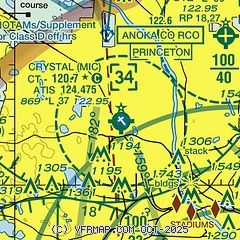
|
 Download PDF
of official airport diagram from the FAA
| Airport distance calculator |
|---|
|
|
| Sunrise and sunset |
|---|
|
Times for 31-Jul-2026
| | Local
(UTC-5) | | Zulu
(UTC) |
|---|
| Morning civil twilight | | 05:25 | | 10:25 |
| Sunrise | | 05:58 | | 10:58 |
| Sunset | | 20:41 | | 01:41 |
| Evening civil twilight | | 21:15 | | 02:15 |
|
| Current date and time |
|---|
| Zulu (UTC) | 31-Jul-2026 17:47:37 |
|---|
| Local (UTC-5) | 31-Jul-2026 12:47:37 |
|---|
|
| METAR |
|---|
| KMIC | 311653Z 03013G21KT 5SM -RA BR FEW020 BKN060 OVC090 18/17 A2993 RMK AO2 SLP132 P0018 T01780167
|
KANE
7nm NE | 311645Z VRB04KT 1 1/4SM -RA BR FEW006 SCT011 OVC025 18/17 A2995
|
KMSP
12nm SE | 311733Z 02017G27KT 7SM -RA SCT010 OVC075 18/17 A2991 RMK AO2 PK WND 03027/1731 P0010 T01830167
|
KFCM
15nm S | 311711Z 02015G26KT 2 1/2SM -RA BR FEW009 BKN055 OVC080 18/17 A2989 RMK AO2 PK WND 02026/1711 P0006 T01780167
|
KSTP
15nm SE | 311741Z 03014G19KT 4SM -RA BR FEW014 BKN029 OVC070 19/17 A2992 RMK AO2 P0010 T01890172
|
KSGS
15nm SE | 311735Z AUTO 36012G17KT 7SM -RA SCT009 BKN012 OVC070 20/19 A2990 RMK AO2 P0001 T01950192
|
|
| TAF |
|---|
KMSP
12nm SE | 311402Z 3114/0118 05015G25KT 6SM -SHRA SCT025 BKN035 TEMPO 3115/3117 5SM -RA FM312200 04012G22KT P6SM -SHRA BKN080 FM010000 02010KT P6SM OVC080 FM010800 35007KT P6SM SCT200
|
|
| NOTAMs |
|---|
NOTAMs are issued by the DoD/FAA and will open in a separate window not controlled by AirNav.
|
|


