FAA INFORMATION EFFECTIVE 19 MARCH 2026
Location
| FAA Identifier: | MUT |
| Lat/Long: | 41-22-04.4000N 091-08-53.6000W
41-22.073333N 091-08.893333W
41.3678889,-91.1482222
(estimated) |
| Elevation: | 547.2 ft. / 166.8 m (surveyed) |
| Variation: | 01W (2000) |
| From city: | 5 miles SW of MUSCATINE, IA |
| Time zone: | UTC -5 (UTC -6 during Standard Time) |
| Zip code: | 52761 |
Airport Operations
| Airport use: | Open to the public |
| Activation date: | 05/1947 |
| Control tower: | no |
| ARTCC: | CHICAGO CENTER |
| FSS: | FORT DODGE FLIGHT SERVICE STATION |
| NOTAMs facility: | MUT (NOTAM-D service available) |
| Attendance: | MON - FRI 0700-1800, ALL SAT - SUN 0800-1600
FOR ATTENDANT AFT HRS CALL (563) 263-8672; ARPT UNATNDD CITY HOLIDAYS. |
| Wind indicator: | lighted |
| Segmented circle: | no |
| Lights: | MIRL RYS 06/24 & 12/30 PRESET ON LOW INTST; TO INCR INTST & ACTVT VASI RY 06; MALSR RY 24; PAPI RYS 24, 12 & 30; REIL RYS 06; 12 & 30 - CTAF. |
| Beacon: | white-green (lighted land airport)
Operates sunset to sunrise. |
Airport Communications
| CTAF/UNICOM: | 122.7 |
| WX AWOS-3P: | 120.625 (563-263-0902) |
| QUAD CITY APPROACH: | 133.275 |
| QUAD CITY DEPARTURE: | 133.275 |
| CLEARANCE DELIVERY: | 119.125 |
- APCH/DEP SVC PRVDD BY CHICAGO ARTCC ON FREQS 118.75/377.05 (MOLINE RCAG) WHEN QUAD CITY APCH CLSD.
Nearby radio navigation aids
| VOR radial/distance | | VOR name | | Freq | | Var |
|---|
| IOWr108/22.8 | | IOWA CITY VOR/DME | | 116.20 | | 05E |
| MZVr272/23.1 | | MOLINE VOR/DME | | 114.40 | | 05E |
| CVAr232/36.2 | | DAVENPORT VORTAC | | 113.80 | | 04E |
| BRLr340/40.0 | | BURLINGTON VOR/DME | | 115.55 | | 05E |
Airport Services
| Fuel available: | 100LL JET-A |
| Parking: | hangars and tiedowns |
| Airframe service: | MINOR |
| Powerplant service: | MINOR |
| Bottled oxygen: | NONE |
| Bulk oxygen: | NONE |
Runway Information
Runway 6/24
| Dimensions: | 5500 x 100 ft. / 1676 x 30 m |
| Surface: | concrete/grooved, in good condition |
| Weight bearing capacity: | | PCN 20 /R/C/W/T | | Single wheel: | 58.0 | | Double wheel: | 73.0 |
|
| Runway edge lights: | medium intensity |
| RUNWAY 6 | | RUNWAY 24 |
| Latitude: | 41-21.737833N | | 41-22.211053N |
| Longitude: | 091-09.266395W | | 091-08.241362W |
| Elevation: | 544.7 ft. | | 541.4 ft. |
| Traffic pattern: | left | | left |
| Runway heading: | 059 magnetic, 058 true | | 240 magnetic, 239 true |
| Markings: | nonprecision, in fair condition | | precision, in fair condition |
| Visual slope indicator: | 4-box VASI on left (3.00 degrees glide path) | | 4-light PAPI on right (3.00 degrees glide path) |
| Approach lights: | | | MALSR: 1,400 foot medium intensity approach lighting system with runway alignment indicator lights |
| Runway end identifier lights: | yes | | no |
| Touchdown point: | yes, no lights | | yes, no lights |
| Instrument approach: | | | ILS/DME |
| Obstructions: | 77 ft. tree, 2097 ft. from runway, 102 ft. left of centerline, 24:1 slope to clear | | none |
Runway 12/30
| Dimensions: | 4000 x 75 ft. / 1219 x 23 m |
| Surface: | concrete/grooved, in good condition |
| Weight bearing capacity: | | PCN 9 /R/C/W/T | | Single wheel: | 28.5 | | Double wheel: | 39.0 |
|
| Runway edge lights: | medium intensity |
| RUNWAY 12 | | RUNWAY 30 |
| Latitude: | 41-22.397305N | | 41-22.018757N |
| Longitude: | 091-09.443983W | | 091-08.728372W |
| Elevation: | 535.8 ft. | | 543.1 ft. |
| Traffic pattern: | left | | left |
| Runway heading: | 126 magnetic, 125 true | | 306 magnetic, 305 true |
| Markings: | nonprecision, in fair condition | | nonprecision, in fair condition |
| Visual slope indicator: | 2-light PAPI on left (3.25 degrees glide path) | | 2-light PAPI on left (3.00 degrees glide path) |
| Runway end identifier lights: | yes | | yes |
| Touchdown point: | yes, no lights | | yes, no lights |
| Obstructions: | 8 ft. tree, 353 ft. from runway, 13 ft. right of centerline, 19:1 slope to clear | | none |
Airport Ownership and Management from official FAA records
| Ownership: | Publicly-owned |
| Owner: | CITY OF MUSCATINE
215 SYCAMORE
MUSCATINE, IA 52761
Phone 563-264-1550 |
| Manager: | MIKE WOERLY
5701 SOUTH HIGHWAY 61
MUSCATINE, IA 52761
Phone 563-263-8672 |
Additional Remarks
| - | GLIDER OPN ON ARPT. |
| - | FOR CD CTC CHICAGO ARTCC AT 630-906-8921. |
Instrument Procedures
NOTE: All procedures below are presented as PDF files. If you need a reader for these files, you should download the free Adobe Reader.NOT FOR NAVIGATION. Please procure official charts for flight.
FAA instrument procedures published for use from 19 March 2026 at 0901Z to 16 April 2026 at 0900Z.
IAPs - Instrument Approach Procedures |
|---|
| ILS OR LOC RWY 24 | |
download (276KB) |
| RNAV (GPS) RWY 06 | |
download (280KB) |
| RNAV (GPS) RWY 12 | |
download (241KB) |
| RNAV (GPS) RWY 24 | |
download (331KB) |
| RNAV (GPS) RWY 30 | |
download (259KB) |
| NOTE: Special Alternate Minimums apply | |
download (146KB) |
| NOTE: Special Take-Off Minimums/Departure Procedures apply | |
download (314KB) |
Other nearby airports with instrument procedures:
8C4 - Mathews Memorial Airport (24 nm N)
KIOW - Iowa City Municipal Airport (24 nm NW)
KAWG - Washington Municipal Airport (24 nm W)
KDVN - Davenport Municipal Airport (29 nm NE)
KMLI - Quad Cities International Airport (29 nm E)
|
|

Road maps at:
MapQuest
Bing
Google
| Aerial photo |
|---|
WARNING: Photo may not be current or correct

Do you have a better or more recent aerial photo of Muscatine Municipal Airport that you would like to share? If so, please send us your photo.
|
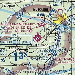
| Sectional chart |
|---|
|
CAUTION: Diagram may not be current

| Airport distance calculator |
|---|
|
|
| Sunrise and sunset |
|---|
|
Times for 07-Apr-2026
| | Local
(UTC-5) | | Zulu
(UTC) |
|---|
| Morning civil twilight | | 06:11 | | 11:11 |
| Sunrise | | 06:39 | | 11:39 |
| Sunset | | 19:35 | | 00:35 |
| Evening civil twilight | | 20:03 | | 01:03 |
|
| Current date and time |
|---|
| Zulu (UTC) | 07-Apr-2026 22:26:21 |
|---|
| Local (UTC-5) | 07-Apr-2026 17:26:21 |
|---|
|
| METAR |
|---|
| KMUT | 072215Z AUTO 14007KT 10SM BKN055 06/M04 A3036 RMK A01
|
|
| TAF |
|---|
KMLI
29nm E | 071725Z 0718/0818 10010G18KT P6SM FEW040 BKN120 FM072200 12011KT P6SM BKN120 FM080800 15014G22KT P6SM BKN050 OVC200 FM081400 18017G24KT P6SM SCT050 BKN200
|
|
| NOTAMs |
|---|
NOTAMs are issued by the DoD/FAA and will open in a separate window not controlled by AirNav.
|
|


