FAA INFORMATION EFFECTIVE 22 JANUARY 2026
Location
| FAA Identifier: | OMA |
| Lat/Long: | 41-18-11.4000N 095-53-38.6000W
41-18.190000N 095-53.643333W
41.3031667,-95.8940556
(estimated) |
| Elevation: | 984.5 ft. / 300.1 m (surveyed) |
| Variation: | 02E (2020) |
| From city: | 3 miles NE of OMAHA, NE |
| Time zone: | UTC -6 (UTC -5 during Daylight Saving Time) |
| Zip code: | 68110 |
Airport Operations
| Airport use: | Open to the public |
| Activation date: | 04/1940 |
| Control tower: | yes |
| ARTCC: | MINNEAPOLIS CENTER |
| FSS: | COLUMBUS FLIGHT SERVICE STATION |
| NOTAMs facility: | OMA (NOTAM-D service available) |
| Attendance: | CONTINUOUS |
| Wind indicator: | lighted |
| Segmented circle: | no |
| Lights: | 24 HRS |
| Beacon: | white-green (lighted land airport)
24 HRS |
| Fire and rescue: | ARFF index C |
| International operations: | customs landing rights airport |
Airport Communications
| UNICOM: | 122.95 |
| WX ASOS: | PHONE 402-271-7515 |
| OMAHA GROUND: | 121.9 |
| OMAHA TOWER: | 132.1 256.9 |
| OMAHA APPROACH: | 124.5 ;EAST 135.875 ;WEST |
| OMAHA DEPARTURE: | 124.5 ;EAST 135.875 ;WEST |
| CLEARANCE DELIVERY: | 119.9 |
| AANDY STAR: | 124.5 ;EAST 135.875 ;WEST |
| CLASS C: | 124.5 ;EAST 135.875 ;WEST |
| D-ATIS: | 120.4 |
| HOWRY STAR: | 124.5 ;EAST 135.875 ;WEST |
| IC: | 135.875 ;WEST |
| LANTK STAR: | 124.5 ;EAST 135.875 ;WEST |
| MARWI STAR: | 124.5 ;EAST 135.875 ;WEST |
| OMAHA DP: | 124.5 ;EAST 135.875 ;WEST |
| TIMMO STAR: | 124.5 ;EAST 135.875 ;WEST |
| WX AWOS-3 at CBF (7 nm SE): | 126.575 (712-323-1542) |
| WX AWOS-3 at MLE (12 nm SW): | 118.25 (402-895-6778) |
| WX AWOS-3 at BTA (12 nm NW): | 120.225 (402-426-0448) |
- SAID IN USE. OPERATE TRANSPONDERS WITH ALTITUDE REPORTING MODE AND ADS-B (IF EQUIPPED) ENABLED ON ALL AIRPORT SURFACES.
Nearby radio navigation aids
| VOR radial/distance | | VOR name | | Freq | | Var |
|---|
| OVRr311/10.8 | | OMAHA VORTAC | | 116.30 | | 08E |
| SCBr113/37.7 | | SCRIBNER VOR/DME | | 111.00 | | 06E |
| NDB name | | Hdg/Dist | | Freq | | Var | | ID |
|---|
| PLATTSMOUTH | | 357/21.6 | | 329 | | 05E | | PMV | .--. -- ...- |
| WAHOO | | 077/32.0 | | 400 | | 06E | | AHQ | .- .... --.- |
Airport Services
| Fuel available: | 100LL JET-A JET-A+ |
| Parking: | hangars and tiedowns |
| Airframe service: | MAJOR |
| Powerplant service: | MAJOR |
| Bottled oxygen: | HIGH |
| Bulk oxygen: | HIGH/LOW |
Runway Information
Runway 14R/32L
| Dimensions: | 9502 x 150 ft. / 2896 x 46 m |
| Surface: | concrete/grooved, in excellent condition |
| Weight bearing capacity: | | Single wheel: | 100.0 | | Double wheel: | 184.0 | | Double tandem: | 346.0 |
|
| Runway edge lights: | high intensity |
| RUNWAY 14R | | RUNWAY 32L |
| Latitude: | 41-18.830502N | | 41-17.558412N |
| Longitude: | 095-54.365122W | | 095-53.157002W |
| Elevation: | 984.1 ft. | | 980.3 ft. |
| Traffic pattern: | left | | left |
| Runway heading: | 142 magnetic, 144 true | | 322 magnetic, 324 true |
| Declared distances: | TORA:9502 TODA:9502 ASDA:9502 LDA:9502 | | TORA:9502 TODA:9502 ASDA:9502 LDA:9502 |
| Markings: | precision, in good condition | | precision, in good condition |
| Visual slope indicator: | 4-light PAPI on left (3.00 degrees glide path) | | 4-light PAPI on right (3.00 degrees glide path) |
| RVR equipment: | touchdown, midfield, rollout | | touchdown, midfield, rollout |
| Approach lights: | ALSF2: standard 2,400 foot high intensity approach lighting system with centerline sequenced flashers (category II or III) | | MALSR: 1,400 foot medium intensity approach lighting system with runway alignment indicator lights |
| Runway end identifier lights: | no | | no |
| Centerline lights: | yes | | yes |
| Touchdown point: | yes, lighted | | yes, no lights |
| Instrument approach: | ILS/DME | | ILS/DME |
Runway 14L/32R
| Dimensions: | 8500 x 150 ft. / 2591 x 46 m |
| Surface: | concrete/grooved, in excellent condition |
| Weight bearing capacity: | | Single wheel: | 100.0 | | Double wheel: | 209.0 | | Double tandem: | 345.0 |
|
| Runway edge lights: | high intensity |
| RUNWAY 14L | | RUNWAY 32R |
| Latitude: | 41-18.811830N | | 41-17.673862N |
| Longitude: | 095-54.025042W | | 095-52.944387W |
| Elevation: | 983.9 ft. | | 981.2 ft. |
| Traffic pattern: | left | | right |
| Runway heading: | 142 magnetic, 144 true | | 322 magnetic, 324 true |
| Declared distances: | TORA:8500 TODA:8500 ASDA:8500 LDA:8500 | | TORA:8500 TODA:8500 ASDA:8500 LDA:8500 |
| Markings: | precision, in good condition | | precision, in good condition |
| Visual slope indicator: | 4-light PAPI on left (3.00 degrees glide path) | | 4-light PAPI on right (3.00 degrees glide path) |
| RVR equipment: | touchdown, midfield, rollout | | touchdown, midfield, rollout |
| Approach lights: | MALSR: 1,400 foot medium intensity approach lighting system with runway alignment indicator lights | | ALSF2: standard 2,400 foot high intensity approach lighting system with centerline sequenced flashers (category II or III) |
| Runway end identifier lights: | no | | no |
| Centerline lights: | yes | | yes |
| Touchdown point: | yes, no lights | | yes, lighted |
| Instrument approach: | ILS/DME | | ILS/DME |
Runway 18/36
| Dimensions: | 8154 x 150 ft. / 2485 x 46 m |
| Surface: | concrete/grooved, in excellent condition |
| Weight bearing capacity: | | Single wheel: | 150.0 | | Double wheel: | 175.0 | | Double tandem: | 260.0 |
|
| Runway edge lights: | high intensity |
| RUNWAY 18 | | RUNWAY 36 |
| Latitude: | 41-18.801083N | | 41-17.458483N |
| Longitude: | 095-53.670578W | | 095-53.677163W |
| Elevation: | 981.2 ft. | | 978.4 ft. |
| Traffic pattern: | left | | left |
| Runway heading: | 178 magnetic, 180 true | | 358 magnetic, 000 true |
| Displaced threshold: | 141 ft. | | no |
| Declared distances: | TORA:8153 TODA:8153 ASDA:8153 LDA:8013 | | TORA:8153 TODA:8153 ASDA:8153 LDA:8153 |
| Markings: | precision, in good condition | | precision, in good condition |
| Visual slope indicator: | 4-light PAPI on left (3.00 degrees glide path) | | 4-light PAPI on left (3.00 degrees glide path) |
| RVR equipment: | touchdown, midfield | | |
| Approach lights: | MALSR: 1,400 foot medium intensity approach lighting system with runway alignment indicator lights | | MALSR: 1,400 foot medium intensity approach lighting system with runway alignment indicator lights |
| Runway end identifier lights: | no | | no |
| Touchdown point: | yes, no lights | | yes, no lights |
| Instrument approach: | ILS/DME | | ILS/DME |
| Obstructions: | none | | 110 ft. brdg, lighted, 4573 ft. from runway, 865 ft. right of centerline, 39:1 slope to clear |
Airport Ownership and Management from official FAA records
| Ownership: | Publicly-owned |
| Owner: | OMAHA AIRPORT AUTHORITY
4501 ABBOTT DRIVE, SUITE 2300
OMAHA, NE 68110
Phone 402-661-8000 |
| Manager: | MR. DAVID L. ROTH
4501 ABBOTT DRIVE, SUITE 2300
OMAHA, NE 68110
Phone 402-661-8000
CEO OF OMAHA ARPT AUTH. |
Additional Remarks
| A39-18/36 | PCR VALUE: 848/R/C/W/T |
| A39-14R/32L | PCR VALUE: 848/R/C/W/T |
| A39-14L/32R | PCR VALUE: 848/R/C/W/T |
| - | BIRDS ON AND INVOF ARPT. |
| - | HLDG BAY AT RWY 32R CLSD EXC ACFT WITH WINGSPAN LESS THAN 79 FT. HLDG BAY AT RWY 18 CLSD EXC ACFT WITH WINGSPAN LESS THAN 79 FT. HLDG BAY AT RWY 32L CLSD EXC ACFT WITH WINGSPAN LESS THAN 118 FT. |
| - | APN TRML RAMP TXL BTN TWY F1 & TWY A1 CLSD TO ACFT WINGSPAN MORE THAN 118 FT. |
| - | TWY F1, F2, & F3 CLSD TO ACFT WINGSPAN MORE THAN 118FT. |
| - | APN TRML RAMP WIP HVY EQPT BTN TWY A1 AND TWY F1. |
| - | APN TRML RAMP BTN GATE A1 & GATE B19 CLSD. |
| - | NOISE MITIGATION PROCEDURES PROHIBIT VFR PATTERNS FOR MILITARY TURBOJET ACFT BETWEEN 0500-1200Z. |
Instrument Procedures
NOTE: All procedures below are presented as PDF files. If you need a reader for these files, you should download the free Adobe Reader.NOT FOR NAVIGATION. Please procure official charts for flight.
FAA instrument procedures published for use from 22 January 2026 at 0901Z to 19 February 2026 at 0900z.
STARs - Standard Terminal Arrivals |
|---|
| AANDY TWO (RNAV) | |
2 pages:
[1] [2] (287KB) |
| HOWRY THREE | |
download (221KB) |
| LANTK TWO | |
download (130KB) |
| MARWI FOUR | |
download (152KB) |
| TIMMO ONE (RNAV) | |
download (193KB) |
IAPs - Instrument Approach Procedures |
|---|
| ILS OR LOC RWY 14L | |
download (223KB) |
| ILS OR LOC RWY 14R | |
download (239KB) |
| ILS OR LOC RWY 18 | |
download (219KB) |
| ILS OR LOC RWY 32L | |
download (232KB) |
| ILS OR LOC RWY 32R | |
download (218KB) |
| ILS OR LOC RWY 36 | |
download (264KB) |
| ILS RWY 14R (SA CAT I) | |
download (222KB) |
| ILS RWY 14R (CAT II - III) | |
download (217KB) |
| ILS RWY 32R (CAT II - III) | |
download (199KB) |
| RNAV (RNP) Z RWY 14L | |
download (268KB) |
| RNAV (RNP) Z RWY 14R | |
download (255KB) |
| RNAV (RNP) Z RWY 18 | |
download (249KB) |
| RNAV (RNP) Z RWY 32L | |
download (274KB) |
| RNAV (RNP) Z RWY 32R | |
download (262KB) |
| RNAV (RNP) Z RWY 36 | |
download (248KB) |
| RNAV (GPS) Y RWY 14L | |
download (251KB) |
| RNAV (GPS) Y RWY 14R | |
download (240KB) |
| RNAV (GPS) Y RWY 18 | |
download (234KB) |
| RNAV (GPS) Y RWY 32L | |
download (239KB) |
| RNAV (GPS) Y RWY 32R | |
download (233KB) |
| RNAV (GPS) Y RWY 36 | |
download (248KB) |
| RNAV (GPS) Y RWY 36 | |
download (248KB) |
| NOTE: Special Alternate Minimums apply | |
download (35KB) |
Departure Procedures |
|---|
| OMAHA ONE | |
download (135KB) |
| NOTE: Special Take-Off Minimums/Departure Procedures apply | |
download (219KB) |
Other nearby airports with instrument procedures:
KCBF - Council Bluffs Municipal Airport (7 nm SE)
KOFF - Offutt Air Force Base (11 nm S)
KMLE - Millard Airport (12 nm SW)
KBTA - Blair Executive Airport (12 nm NW)
KPMV - Plattsmouth Municipal Airport/Douglas V Duey Field (21 nm S)
|
|

Road maps at:
MapQuest
Bing
Google
| Aerial photo |
|---|
WARNING: Photo may not be current or correct
 Photo by Mike and Shelby Knockenhauer
Taken in 2016
looking north
Photo by Mike and Shelby Knockenhauer
Taken in 2016
looking north
Do you have a better or more recent aerial photo of Eppley Airfield that you would like to share? If so, please send us your photo.
|
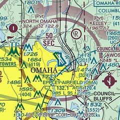
| Sectional chart |
|---|
|
CAUTION: Diagram may not be current
 Download PDF
of official airport diagram from the FAA
| Airport distance calculator |
|---|
|
|
| Sunrise and sunset |
|---|
|
Times for 17-Feb-2026
| | Local
(UTC-6) | | Zulu
(UTC) |
|---|
| Morning civil twilight | | 06:48 | | 12:48 |
| Sunrise | | 07:17 | | 13:17 |
| Sunset | | 17:59 | | 23:59 |
| Evening civil twilight | | 18:27 | | 00:27 |
|
| Current date and time |
|---|
| Zulu (UTC) | 17-Feb-2026 10:02:30 |
|---|
| Local (UTC-6) | 17-Feb-2026 04:02:30 |
|---|
|
| METAR |
|---|
| KOMA | 170952Z 15007KT 10SM OVC160 08/05 A2970 RMK AO2 SLP054 T00830050 $
|
KCBF
6nm E | 170955Z AUTO 13008KT 10SM CLR 08/06 A2969 RMK AO2
|
KOFF
11nm S | 170955Z 15003KT 10SM SCT160 OVC200 08/05 A2969 RMK AO2A SLP057 T00820046
|
KMLE
12nm SW | 170935Z AUTO 14005KT 10SM CLR 08/05 A2969 RMK AO2 T00820047
|
KBTA
12nm NW | 170935Z AUTO 00000KT 10SM CLR 10/05 A2969 RMK AO2 T00970050
|
|
| TAF |
|---|
| KOMA | 170520Z 1706/1806 14005KT P6SM BKN200 FM171200 14012G19KT P6SM OVC190 FM171700 17020G30KT P6SM BKN200 FM180100 22014G22KT P6SM SCT200
|
KOFF
11nm S | 170300Z 1703/1809 17009KT 9999 FEW040 QNH2979INS BECMG 1706/1707 13010G15KT 9999 BKN015 BKN180 QNH2963INS WND 13012G18KT AFT 1713 BECMG 1714/1715 15020G30KT 9999 BKN150 QNH2930INS BECMG 1722/1723 17025G35KT 9999 BKN040 QNH2926INS BECMG 1800/1801 21015G25KT 9000 -SHRA OVC020 QNH2931INS TEMPO 1801/1803 21025G35KT BECMG 1802/1803 21010G15KT 9999 NSW OVC020 QNH2936INS TX21/1721Z TN09/1705Z
|
|
| NOTAMs |
|---|
NOTAMs are issued by the DoD/FAA and will open in a separate window not controlled by AirNav.
|
|


