FAA INFORMATION EFFECTIVE 19 MARCH 2026
Location
| FAA Identifier: | PNC |
| Lat/Long: | 36-43-55.0370N 097-05-59.2160W
36-43.917283N 097-05.986933W
36.7319547,-97.0997822
(estimated) |
| Elevation: | 1008.6 ft. / 307.4 m (surveyed) |
| Variation: | 05E (2005) |
| From city: | 2 miles NW of PONCA CITY, OK |
| Time zone: | UTC -5 (UTC -6 during Standard Time) |
| Zip code: | 74601 |
Airport Operations
| Airport use: | Open to the public |
| Activation date: | 11/1938 |
| Control tower: | no |
| ARTCC: | KANSAS CITY CENTER |
| FSS: | MC ALESTER FLIGHT SERVICE STATION |
| NOTAMs facility: | PNC (NOTAM-D service available) |
| Attendance: | 0700-1900 |
| Wind indicator: | lighted |
| Segmented circle: | yes |
| Lights: | ACTVT MALSR RWY 17; ODALS RWY 35; HIRL RWY 17/35 - CTAF. PAPI RWY 17 & 35 ON CONSLY. |
| Beacon: | white-green (lighted land airport)
Operates sunset to sunrise. |
Airport Communications
| CTAF/UNICOM: | 123.0 |
| WX ASOS: | 134.075 (580-765-0049) |
| WX AWOS-3PT at BKN (12 nm W): | 120.575 (580-363-0688) |
- APCH/DEP CTL SVC PRVDD BY KANSAS CITY ARTCC (ZKC) ON FREQS 127.8/319.1 (PONCA CITY RCAG).
Nearby radio navigation aids
| VOR radial/distance | | VOR name | | Freq | | Var |
|---|
| PERr101/3.0 | | PIONEER VORTAC | | 113.20 | | 06E |
| SWOr351/30.5 | | STILLWATER VOR/DME | | 108.40 | | 07E |
| ODGr049/39.5 | | WOODRING VOR/DME | | 109.00 | | 08E |
| NDB name | | Hdg/Dist | | Freq | | Var | | ID |
|---|
| PONCA | | 175/5.6 | | 515 | | 05E | | PN | .--. -. |
Airport Services
| Fuel available: | 100LL JET-A+
100LL:100LL AVBL 24 HRS; SVC AVBL 0700-DUSK; OTR TIMES - 580-767-0429. |
| Parking: | hangars and tiedowns |
| Airframe service: | MAJOR |
| Powerplant service: | MAJOR |
| Bottled oxygen: | NONE |
| Bulk oxygen: | NONE |
Runway Information
Runway 17/35
| Dimensions: | 7201 x 100 ft. / 2195 x 30 m
NORTH 2400 FT NSTD PLASTIC GROOVING ENTIRE WIDTH; 25 FT EACH EDGE REMAINING 4801 FT. |
| Surface: | concrete/grooved, in good condition |
| Weight bearing capacity: | | Single wheel: | 51.0 | | Double wheel: | 65.0 | | Double tandem: | 122.0 |
|
| Runway edge lights: | high intensity |
| RUNWAY 17 | | RUNWAY 35 |
| Latitude: | 36-44.510600N | | 36-43.323958N |
| Longitude: | 097-05.991697W | | 097-05.982187W |
| Elevation: | 993.7 ft. | | 1008.6 ft. |
| Traffic pattern: | right | | left |
| Runway heading: | 175 magnetic, 180 true | | 355 magnetic, 360 true |
| Markings: | precision, in good condition | | precision, in fair condition |
| Visual slope indicator: | 4-light PAPI on left (3.00 degrees glide path) | | 4-light PAPI on left (3.00 degrees glide path)
PAPI UNUSBL BYD 8 DEGS RIGHT OF CNTRLN. |
| Approach lights: | MALSR: 1,400 foot medium intensity approach lighting system with runway alignment indicator lights | | ODALS: omnidirectional approach lighting system |
| Runway end identifier lights: | | | no |
| Touchdown point: | yes, no lights | | yes, no lights |
| Instrument approach: | ILS/DME | | |
| Obstructions: | none | | 28 ft. bldg, lighted, 710 ft. from runway, 555 ft. left of centerline, 18:1 slope to clear |
Airport Ownership and Management from official FAA records
| Ownership: | Publicly-owned |
| Owner: | CITY OF PONCA CITY
BOX 1450
PONCA CITY, OK 74602
Phone 580-767-0300 |
| Manager: | DON NUZUM
BOX 1450
PONCA CITY, OK 74602
Phone 580-767-0470 |
Additional Remarks
| - | ULTRALIGHTS ON & INVOF ARPT. |
| - | FOR CD IF UNA TO CTC ON FSS FREQ, CTC KANSAS CITY ARTCC AT 913-254-8508. |
Instrument Procedures
NOTE: All procedures below are presented as PDF files. If you need a reader for these files, you should download the free Adobe Reader.NOT FOR NAVIGATION. Please procure official charts for flight.
FAA instrument procedures published for use from 19 March 2026 at 0901Z to 16 April 2026 at 0900Z.
IAPs - Instrument Approach Procedures |
|---|
| ILS OR LOC RWY 17 | |
download (235KB) |
| RNAV (GPS) RWY 17 | |
download (230KB) |
| RNAV (GPS) RWY 35 | |
download (271KB) |
| VOR-A | |
download (163KB) |
| NOTE: Special Alternate Minimums apply | |
download (122KB) |
| NOTE: Special Take-Off Minimums/Departure Procedures apply | |
download (131KB) |
Other nearby airports with instrument procedures:
KBKN - Blackwell-Tonkawa Municipal Airport (12 nm W)
F22 - Perry Municipal Airport (22 nm S)
KWLD - Strother Field Airport (26 nm N)
O53 - Medford Municipal Airport (31 nm W)
KSWO - Stillwater Regional Airport (34 nm S)
|
|

Road maps at:
MapQuest
Bing
Google
| Aerial photo |
|---|
WARNING: Photo may not be current or correct

Do you have a better or more recent aerial photo of Ponca City Regional Airport that you would like to share? If so, please send us your photo.
|
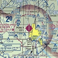
| Sectional chart |
|---|
|
CAUTION: Diagram may not be current

| Airport distance calculator |
|---|
|
|
| Sunrise and sunset |
|---|
|
Times for 15-Apr-2026
| | Local
(UTC-5) | | Zulu
(UTC) |
|---|
| Morning civil twilight | | 06:29 | | 11:29 |
| Sunrise | | 06:55 | | 11:55 |
| Sunset | | 20:02 | | 01:02 |
| Evening civil twilight | | 20:28 | | 01:28 |
|
| Current date and time |
|---|
| Zulu (UTC) | 16-Apr-2026 00:57:57 |
|---|
| Local (UTC-5) | 15-Apr-2026 19:57:57 |
|---|
|
| METAR |
|---|
| KPNC | 160053Z AUTO 00000KT 10SM CLR 19/15 A2975 RMK AO2 LTG DSNT E AND SE RAB00E22 TSB2358E27 SLP065 P0007 T01940150
|
KBKN
12nm W | 160055Z AUTO 01005KT 10SM SCT110 24/14 A2977 RMK AO2
|
|
| TAF |
|---|
| KPNC | 151730Z 1518/1618 22015G25KT P6SM SCT035 TEMPO 1520/1523 VRB25KT 4SM TSRA BKN040CB FM160000 VRB04KT P6SM FEW100 FEW280 FM161000 VRB04KT P6SM OVC008 FM161600 18010G15KT P6SM BKN020
|
|
| NOTAMs |
|---|
NOTAMs are issued by the DoD/FAA and will open in a separate window not controlled by AirNav.
|
|


