FAA INFORMATION EFFECTIVE 14 MAY 2026
Location
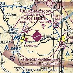
| FAA Identifier: | PUW |
| Lat/Long: | 46-44-30.0890N 117-06-41.8290W
46-44.501483N 117-06.697150W
46.7416914,-117.1116192
(estimated) |
| Elevation: | 2566.6 ft. / 782.3 m (surveyed) |
| Variation: | 15E (2015) |
| From city: | 3 miles NE of central business district of the associated city |
| Time zone: | UTC -7 (UTC -8 during Standard Time) |
| Zip code: | 99163 |
Airport Operations
| Airport use: | Open to the public |
| Activation date: | 02/1938 |
| Control tower: | no |
| ARTCC: | SEATTLE CENTER |
| FSS: | SEATTLE FLIGHT SERVICE STATION |
| NOTAMs facility: | PUW (NOTAM-D service available) |
| Attendance: | 0800-1800 |
| Wind indicator: | lighted |
| Segmented circle: | yes |
| Lights: | ACTVT MALSR RWY 05; REIL RWY 23; PAPI RWY 05 & 23; HIRL RWY 5/23 - CTAF. |
| Beacon: | white-green (lighted land airport)
Operates sunset to sunrise. |
| Landing fee: | yes, COML & ITNRNT OVR 7000 LBS LNDG FEE. |
| Fire and rescue: | ARFF index B |
| Airline operations: | CLSD TO UNSKED ACR OPS GTR THAN 30 PAX SEATS EXC PPR - AMGR. |
Airport Communications
| CTAF/UNICOM: | 122.8 |
| WX ASOS: | 135.675 (509-334-3222) |
- APCH/DEP CTL SVC PRVDD BY SEATTLE ARTCC (ZSE) ON FREQS 123.95/290.55 (COTTONWOOD RCAG).
Nearby radio navigation aids
| VOR radial/distance | | VOR name | | Freq | | Var |
|---|
| PUWr029/6.1 | | PULLMAN VOR/DME | | 117.15 | | 20E |
| MQGr315/23.8 | | NEZ PERCE VOR/DME | | 114.45 | | 20E |
Airport Services
| Fuel available: | 100LL JET-A |
| Parking: | tiedowns |
| Airframe service: | MAJOR |
| Powerplant service: | MAJOR |
Runway Information
Runway 5/23
| Dimensions: | 7100 x 150 ft. / 2164 x 46 m |
| Surface: | asphalt/grooved, in good condition |
| Weight bearing capacity: | | Single wheel: | 120.0 | | Double wheel: | 168.0 | | Double tandem: | 227.0 | | Dual double tandem: | 658.0 |
|
| Runway edge lights: | high intensity |
| RUNWAY 5 | | RUNWAY 23 |
| Latitude: | 46-44.250658N | | 46-44.752255N |
| Longitude: | 117-07.464288W | | 117-05.930052W |
| Elevation: | 2566.6 ft. | | 2552.3 ft. |
| Traffic pattern: | left | | left |
| Runway heading: | 050 magnetic, 065 true | | 230 magnetic, 245 true |
| Declared distances: | TORA:7100 TODA:7100 ASDA:7100 LDA:7100 | | TORA:7100 TODA:7100 ASDA:7100 LDA:7100 |
| Markings: | precision, in good condition | | precision, in good condition |
| Visual slope indicator: | 4-light PAPI on left (3.00 degrees glide path) | | 4-light PAPI on right (3.40 degrees glide path) |
| RVR equipment: | touchdown | | rollout |
| Approach lights: | MALSR: 1,400 foot medium intensity approach lighting system with runway alignment indicator lights | | |
| Runway end identifier lights: | no | | yes |
| Touchdown point: | yes, no lights | | yes, no lights |
| Instrument approach: | ILS/DME | | |
| Obstructions: | 7 ft. fence, 374 ft. from runway, 253 ft. left of centerline, 24:1 slope to clear | | 29 ft. gnd, 200 ft. from runway, 250 ft. left of centerline |
Airport Ownership and Management from official FAA records
| Ownership: | Publicly-owned |
| Owner: | PULLMAN MOSCOW RGL ARPT BOARD
3200 AIRPORT COMPLEX N
PULLMAN, WA 99163
Phone 509-338-3223 |
| Manager: | ANTHONY BEAN
3200 AIRPORT COMPLEX N
PULLMAN, WA 99163
Phone 509-338-3223 |
Additional Remarks
| A39-05/23 | PCR VALUE: 520/F/D/X/T |
| - | NON PAVED AREA OPS NA. PRKG BTN RWY & TWY NA. |
| - | OBSTNS PENETRATE IMAGINARY SFCS N & S OF RWY. |
| - | FOR CD IF UNA TO CTC ON FSS FREQ, CTC SEATTLE ARTCC AT 253-351-3694. |
Instrument Procedures
NOTE: All procedures below are presented as PDF files. If you need a reader for these files, you should download the free Adobe Reader.NOT FOR NAVIGATION. Please procure official charts for flight.
FAA instrument procedures published for use from 14 May 2026 at 0901Z to 11 June 2026 at 0900Z.
IAPs - Instrument Approach Procedures |
|---|
| ILS OR LOC RWY 05 | |
download (262KB) |
| RNAV (RNP) Z RWY 23 | |
download (210KB) |
| RNAV (GPS) RWY 05 | |
download (261KB) |
| RNAV (GPS) Y RWY 23 | |
download (252KB) |
| VOR RWY 05 | |
download (258KB) |
| NOTE: Special Alternate Minimums apply | |
download (86KB) |
| NOTE: Special Take-Off Minimums/Departure Procedures apply | |
download (559KB) |
Other nearby airports with instrument procedures:
KLWS - Lewiston/Nez Perce County Airport (22 nm S)
KGEG - Spokane International Airport (55 nm N)
KSKA - Fairchild Air Force Base (57 nm NW)
KSFF - Felts Field Airport (57 nm N)
KALW - Walla Walla Regional Airport (62 nm SW)
|
|

Road maps at:
MapQuest
Bing
Google
| Aerial photo |
|---|
WARNING: Photo may not be current or correct
 Photo by Kevin Mulcaster
Photo taken 11-Oct-2019
looking east.
Photo by Kevin Mulcaster
Photo taken 11-Oct-2019
looking east.
Do you have a better or more recent aerial photo of Pullman/Moscow Regional Airport that you would like to share? If so, please send us your photo.
|
| Sectional chart |
|---|
|
| Airport distance calculator |
|---|
|
|
| Sunrise and sunset |
|---|
|
Times for 02-Jun-2026
| | Local
(UTC-7) | | Zulu
(UTC) |
|---|
| Morning civil twilight | | 04:20 | | 11:20 |
| Sunrise | | 04:59 | | 11:59 |
| Sunset | | 20:34 | | 03:34 |
| Evening civil twilight | | 21:13 | | 04:13 |
|
| Current date and time |
|---|
| Zulu (UTC) | 03-Jun-2026 00:19:43 |
|---|
| Local (UTC-7) | 02-Jun-2026 17:19:43 |
|---|
|
| METAR |
|---|
| KPUW | 022353Z AUTO 35003KT 10SM CLR 21/08 A3012 RMK AO2 SLP199 T02110078 10211 20167 58008
|
|
| TAF |
|---|
| KPUW | 021720Z 0218/0318 VRB03KT P6SM BKN200 FM022000 27005KT P6SM SCT040 BKN200 FM030200 04004KT P6SM SCT250 FM031500 09008KT P6SM BKN250
|
|
| NOTAMs |
|---|
NOTAMs are issued by the DoD/FAA and will open in a separate window not controlled by AirNav.
|
|

