FAA INFORMATION EFFECTIVE 09 JULY 2026
Location
| FAA Identifier: | RDG |
| Lat/Long: | 40-22-42.5950N 075-57-54.8900W
40-22.709917N 075-57.914833W
40.3784986,-75.9652472
(estimated) |
| Elevation: | 343.4 ft. / 104.7 m (surveyed) |
| Variation: | 12W (2000) |
| From city: | 3 miles NW of READING, PA |
| Time zone: | UTC -4 (UTC -5 during Standard Time) |
| Zip code: | 19605 |
Airport Operations
| Airport use: | Open to the public |
| Activation date: | 04/1938 |
| Control tower: | yes |
| ARTCC: | NEW YORK CENTER |
| FSS: | WILLIAMSPORT FLIGHT SERVICE STATION |
| NOTAMs facility: | RDG (NOTAM-D service available) |
| Attendance: | 0600-2300 |
| Wind indicator: | lighted |
| Segmented circle: | no |
| Lights: | WHEN ATCT CLSD ACTVT MALSF RWY 36; REIL RWY 13, 31; PAPI RWY 13 & 18; HIRL RWY 13/31 & 18/36; TWY LGTS - CTAF. |
| Beacon: | white-green (lighted land airport)
Operates sunset to sunrise. |
| Landing fee: | yes, LNDG FEE FOR TURBINE ACFT. |
| Fire and rescue: | ARFF index A |
| Airline operations: | PPR 24 HRS FOR ACFT OPNS WITH MORE THAN 30 PAX SEATS. CALL AMGR 610-372-4666. |
Airport Communications
| CTAF: | 119.9 |
| UNICOM: | 122.95 |
| ATIS: | 127.1 |
| WX ASOS: | 127.1 (610-372-9863) |
| READING GROUND: | 121.9 [0600-0000] |
| READING TOWER: | 119.9 288.3 [0600-0000] |
| HARRISBURG APPROACH: | 125.15 |
| HARRISBURG DEPARTURE: | 125.15 |
| EMERG: | 121.5 243.0 |
| WX AWOS-2 at 9D4 (17 nm W): | 118.45 (717-866-2906) |
Nearby radio navigation aids
| VOR radial/distance | | VOR name | | Freq | | Var |
|---|
| ETXr236/17.7 | | EAST TEXAS VOR/DME | | 110.20 | | 09W |
| PTWr306/20.8 | | POTTSTOWN VORTAC | | 116.50 | | 09W |
| LRPr053/21.5 | | LANCASTER VOR/DME | | 117.30 | | 09W |
| MXEr343/30.8 | | MODENA VORTAC | | 113.20 | | 09W |
| RAVr121/30.8 | | RAVINE VORTAC | | 114.60 | | 11W |
| FJCr238/31.3 | | ALLENTOWN VORTAC | | 117.50 | | 10W |
| NDB name | | Hdg/Dist | | Freq | | Var | | ID |
|---|
| BELLGROVE | | 107/27.1 | | 328 | | 10W | | BZJ | -... --.. .--- |
Airport Services
| Fuel available: | 100LL JET-A |
| Parking: | hangars and tiedowns |
| Airframe service: | MAJOR |
| Powerplant service: | MAJOR |
| Bottled oxygen: | HIGH/LOW |
| Bulk oxygen: | HIGH/LOW |
Runway Information
Runway 13/31
| Dimensions: | 6350 x 150 ft. / 1935 x 46 m |
| Surface: | asphalt/grooved, in good condition |
| Weight bearing capacity: | | Single wheel: | 75.0 | | Double wheel: | 200.0 | | Double tandem: | 400.0 |
|
| Runway edge lights: | high intensity |
| RUNWAY 13 | | RUNWAY 31 |
| Latitude: | 40-23.014315N | | 40-22.471535N |
| Longitude: | 075-58.686118W | | 075-57.517368W |
| Elevation: | 343.4 ft. | | 329.7 ft. |
| Traffic pattern: | left | | left |
| Runway heading: | 133 magnetic, 121 true | | 313 magnetic, 301 true |
| Declared distances: | TORA:6350 TODA:6350 ASDA:6350 LDA:6350 | | TORA:6350 TODA:6350 ASDA:6350 LDA:6350 |
| Markings: | precision, in good condition | | precision, in good condition |
| Visual slope indicator: | 4-light PAPI on left (3.00 degrees glide path)
PAPI UNUSBL BYD 3 DEGS LEFT OF CNTRLN. | | |
| Runway end identifier lights: | yes | | yes |
| Touchdown point: | yes, no lights | | yes, no lights |
| Instrument approach: | ILS/DME | | |
| Obstructions: | 317 ft. trees, 7661 ft. from runway, 1213 ft. left of centerline, 23:1 slope to clear | | none |
Runway 18/36
| Dimensions: | 5151 x 150 ft. / 1570 x 46 m |
| Surface: | asphalt/grooved, in good condition |
| Weight bearing capacity: | | Single wheel: | 75.0 | | Double wheel: | 200.0 | | Double tandem: | 400.0 |
|
| Runway edge lights: | high intensity |
| RUNWAY 18 | | RUNWAY 36 |
| Latitude: | 40-23.089365N | | 40-22.248997N |
| Longitude: | 075-57.760025W | | 075-57.608967W |
| Elevation: | 290.4 ft. | | 342.3 ft. |
| Traffic pattern: | left | | left |
| Runway heading: | 184 magnetic, 172 true | | 004 magnetic, 352 true |
| Declared distances: | TORA:5151 TODA:5151 ASDA:5151 LDA:5151 | | TORA:5151 TODA:5151 ASDA:5151 LDA:5151 |
| Markings: | precision, in good condition | | precision, in good condition |
| Visual slope indicator: | 4-light PAPI on left (3.00 degrees glide path) | | |
| RVR equipment: | | | touchdown |
| Approach lights: | | | MALSF: 1,400 foot medium intensity approach lighting system with sequenced flashers |
| Touchdown point: | yes, no lights | | yes, no lights |
| Instrument approach: | | | ILS |
| Obstructions: | 60 ft. trees, 893 ft. from runway, 580 ft. right of centerline, 11:1 slope to clear | | 19 ft. trees, 769 ft. from runway, 499 ft. right of centerline, 29:1 slope to clear |
Airport Ownership and Management from official FAA records
| Ownership: | Publicly-owned |
| Owner: | READING REGIONAL ARPT AUTH.
24 LIBERATOR WAY
READING, PA 19605
Phone 610-372-4666 |
| Manager: | ZACKARY J. TEMPESCO
24 LIBERATOR WAY
READING, PA 19605
Phone 610-372-4666 |
Additional Remarks
| A39-18/36 | PCR VALUE: 610/F/C/X/T |
| A39-13/31 | PCR VALUE: 610/F/C/X/T |
| E60-13 | ARRESTING GEAR/SYSTEM: ENGINEERED MATERIAL ARRESTING SYSTEM (EMAS) 255 FT IN LENGTH BY 170 FT IN WIDTH LOCATED AT DEP END RWY 13. |
| - | BIRDS ON & INVOF ARPT. |
| - | FOR CD WHEN ATCT CLSD, CTC HARRISBURG APCH AT 800-932-0712. |
| - | ARFF INDEX C AVBL UPON REQ CTC AMGR. |
Instrument Procedures
NOTE: All procedures below are presented as PDF files. If you need a reader for these files, you should download the free Adobe Reader.NOT FOR NAVIGATION. Please procure official charts for flight.
FAA instrument procedures published for use from 09 July 2026 at 0901Z to 06 August 2026 at 0900Z.
IAPs - Instrument Approach Procedures |
|---|
| ILS OR LOC RWY 13 | |
download (336KB) |
| ILS OR LOC RWY 36 | |
download (315KB) |
| RNAV (GPS) RWY 13 | |
download (303KB) |
| RNAV (GPS) RWY 18 | |
download (245KB) |
| RNAV (GPS) RWY 31 | |
download (228KB) |
| RNAV (GPS) RWY 36 | |
download (304KB) |
| NOTE: Special Alternate Minimums apply | |
download (144KB) |
| NOTE: Special Take-Off Minimums/Departure Procedures apply | |
download (438KB) |
Other nearby airports with instrument procedures:
N47 - Pottstown Municipal Airport (15 nm SE)
9D4 - Deck Airport (17 nm W)
08N - Keller Brothers Airport (17 nm W)
KPTW - Heritage Field Airport (20 nm SE)
KLNS - Lancaster Airport (22 nm SW)
|
|

Road maps at:
MapQuest
Bing
Google
| Aerial photo |
|---|
WARNING: Photo may not be current or correct
 Photo courtesy of AirNav, LLC
Photo taken 21-Apr-2013
looking northwest.
Photo courtesy of AirNav, LLC
Photo taken 21-Apr-2013
looking northwest.
Do you have a better or more recent aerial photo of Reading Regional Airport/Carl A Spaatz Field that you would like to share? If so, please send us your photo.
|
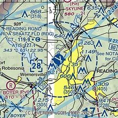
| Sectional chart |
|---|
|
CAUTION: Diagram may not be current
 Download PDF
of official airport diagram from the FAA
| Airport distance calculator |
|---|
|
|
| Sunrise and sunset |
|---|
|
Times for 30-Jul-2026
| | Local
(UTC-4) | | Zulu
(UTC) |
|---|
| Morning civil twilight | | 05:30 | | 09:30 |
| Sunrise | | 06:00 | | 10:00 |
| Sunset | | 20:20 | | 00:20 |
| Evening civil twilight | | 20:51 | | 00:51 |
|
| Current date and time |
|---|
| Zulu (UTC) | 30-Jul-2026 07:09:41 |
|---|
| Local (UTC-4) | 30-Jul-2026 03:09:41 |
|---|
|
| METAR |
|---|
| KRDG | 300554Z 31009KT 10SM SCT038 BKN110 21/17 A2972 RMK AO2 SLP067 60005 T02110167 10233 20200 58004 $
|
|
| TAF |
|---|
| KRDG | 300520Z 3006/3106 30008KT P6SM VCSH BKN040 FM301200 33011G19KT P6SM BKN030 FM301600 34013G21KT P6SM BKN040 FM301900 34009KT P6SM BKN050 FM310100 35003KT P6SM SCT050
|
|
| NOTAMs |
|---|
NOTAMs are issued by the DoD/FAA and will open in a separate window not controlled by AirNav.
|
|


