FAA INFORMATION EFFECTIVE 16 APRIL 2026
Location
| FAA Identifier: | RJD |
| Lat/Long: | 38-58-12.4080N 075-51-58.7680W
38-58.206800N 075-51.979467W
38.9701133,-75.8663244
(estimated) |
| Elevation: | 64 ft. / 19.5 m (surveyed) |
| Variation: | 12W (2005) |
| From city: | 2 miles NE of RIDGELY, MD |
| Time zone: | UTC -4 (UTC -5 during Standard Time) |
| Zip code: | 21660 |
Airport Operations
| Airport use: | Open to the public |
| Activation date: | 11/1966 |
| Control tower: | no |
| ARTCC: | WASHINGTON CENTER |
| FSS: | LEESBURG FLIGHT SERVICE STATION |
| NOTAMs facility: | DCA (NOTAM-D service available) |
| Attendance: | UNATTENDED |
| Wind indicator: | lighted |
| Segmented circle: | yes |
| Lights: | ACTIVATE REIL RWY 12 & 30; LIRL RWY 12/30 - CTAF. |
| Beacon: | white-green (lighted land airport)
ACTVT ARPT BEACON - CTAF. |
Airport Communications
| CTAF/UNICOM: | 122.8 |
| POTOMAC APPROACH: | 124.55 132.425 ;RWY 30 [1200-0400Z++ MON-SUN. OTHER TIMES BY NOTAM.] |
| POTOMAC DEPARTURE: | 124.55 132.425 ;RWY 30 [1200-0400Z++ MON-SUN. OTHER TIMES BY NOTAM.] |
| WX AWOS-3PT at ESN (14 nm SW): | 124.475 (410-822-2817) |
| WX AWOS-3 at 33N (19 nm NE): | 120.125 (302-571-6012) |
Nearby radio navigation aids
| VOR radial/distance | | VOR name | | Freq | | Var |
|---|
| ENOr235/22.6 | | SMYRNA VORTAC | | 111.40 | | 09W |
| ATRr296/32.1 | | WATERLOO VOR/DME | | 112.60 | | 09W |
| BALr119/38.9 | | BALTIMORE VORTAC | | 115.10 | | 11W |
Airport Services
| Parking: | tiedowns |
| Airframe service: | MAJOR |
| Powerplant service: | MAJOR |
Runway Information
Runway 12/30
| Dimensions: | 3214 x 50 ft. / 980 x 15 m |
| Surface: | asphalt, in good condition |
| Weight bearing capacity: | | Single wheel: | 28.0 | | Double wheel: | 39.0 |
|
| Runway edge lights: | low intensity |
| Runway edge markings: | FADED, CRACK SEAL THRU MRKGS.
THR BARS AND RWY NRS ARE HALF SIZE. |
| RUNWAY 12 | | RUNWAY 30 |
| Latitude: | 38-58.327833N | | 38-58.153667N |
| Longitude: | 075-52.430500W | | 075-51.790000W |
| Elevation: | 63.5 ft. | | 63.6 ft. |
| Traffic pattern: | left | | right |
| Runway heading: | 121 magnetic, 109 true | | 301 magnetic, 289 true |
| Markings: | NSTD, in fair condition | | NSTD, in fair condition |
| Runway end identifier lights: | yes | | yes |
| Touchdown point: | yes, no lights | | yes, no lights |
| Obstructions: | 27 ft. pline, marked and lighted, 1170 ft. from runway, 35:1 slope to clear | | 34 ft. trees, 769 ft. from runway, 191 ft. left of centerline, 16:1 slope to clear |
Airport Ownership and Management from official FAA records
| Ownership: | Privately-owned |
| Owner: | AIR-LAND LLC
3532 TURKEY POINT ROAD
VIOLA, DE 19979
Phone 302-270-2227 |
| Manager: | JOHN GOODEN
3532 TURKEY POINT ROAD
VIOLA, DE 19979
Phone 302-270-2227 |
Additional Remarks
| - | FOR CD CTC DOVER APCH AT 302-677-3940. |
| - | TURF AREAS ADJACENT TO ACFT MOVEMENT AREAS SOFT WHEN WET. |
| - | UNLIMITED VEHICLE ACCESS TO ACFT MOVEMENT AREAS. |
| - | BIRDS, DEER & WILDLIFE ON & INVOF ARPT. |
| - | TWY/APN PAVEMENTS ARE FAILING WITH LOOSE AGGREGATE AND ALLIGATOR CRACKING. |
Instrument Procedures
NOTE: All procedures below are presented as PDF files. If you need a reader for these files, you should download the free Adobe Reader.NOT FOR NAVIGATION. Please procure official charts for flight.
FAA instrument procedures published for use from 16 April 2026 at 0901Z to 14 May 2026 at 0900Z.
IAPs - Instrument Approach Procedures |
|---|
| RNAV (GPS) RWY 12 | |
download (196KB) |
| RNAV (GPS) RWY 30 | |
download (193KB) |
| NOTE: Special Take-Off Minimums/Departure Procedures apply | |
download (356KB) |
Other nearby airports with instrument procedures:
KESN - Easton Airport/Newnam Field (14 nm SW)
33N - Delaware Airpark (19 nm NE)
KDOV - Dover Air Force Base (21 nm NE)
W29 - Bay Bridge Airport (22 nm W)
KCGE - Cambridge-Dorchester Regional Airport (27 nm S)
|
|

Road maps at:
MapQuest
Bing
Google
| Aerial photo |
|---|
WARNING: Photo may not be current or correct
 Photo taken 16-Sep-2016
looking north.
Photo taken 16-Sep-2016
looking north.
Do you have a better or more recent aerial photo of Gooden Airpark that you would like to share? If so, please send us your photo.
|
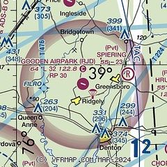
| Sectional chart |
|---|
|
| Airport distance calculator |
|---|
|
|
| Sunrise and sunset |
|---|
|
Times for 09-May-2026
| | Local
(UTC-4) | | Zulu
(UTC) |
|---|
| Morning civil twilight | | 05:28 | | 09:28 |
| Sunrise | | 05:58 | | 09:58 |
| Sunset | | 20:02 | | 00:02 |
| Evening civil twilight | | 20:32 | | 00:32 |
|
| Current date and time |
|---|
| Zulu (UTC) | 09-May-2026 16:46:07 |
|---|
| Local (UTC-4) | 09-May-2026 12:46:07 |
|---|
|
| METAR |
|---|
KESN
14nm SW | 091550Z 21019G29KT 10SM CLR 22/07 A2985
|
K33N
19nm NE | 091635Z AUTO 23013G19KT 200V270 10SM FEW060 FEW070 23/08 A2984 RMK A01
|
|
| TAF |
|---|
KDOV
21nm NE | 091600Z 0916/1022 21012G20KT 9999 BKN100 520006 QNH2982INS BECMG 0918/0919 21012KT 8000 -SHRA BKN050 520105 QNH2978INS TEMPO 0919/0923 18012G21KT VCTS BKN050CB BECMG 1000/1001 18006KT 9999 NSW FEW050 QNH2983INS BECMG 1005/1006 25006KT 4800 BR SKC QNH2985INS TEMPO 1010/1013 1600 BR BECMG 1012/1013 30006KT 9999 NSW SCT060 QNH2989INS TX26/1016Z TN12/1010Z
|
|
| NOTAMs |
|---|
NOTAMs are issued by the DoD/FAA and will open in a separate window not controlled by AirNav.
|
|

