FAA INFORMATION EFFECTIVE 14 MAY 2026
Location
| FAA Identifier: | RZN |
| Lat/Long: | 45-49-24.4700N 092-22-25.2950W
45-49.407833N 092-22.421583W
45.8234639,-92.3736931
(estimated) |
| Elevation: | 989.3 ft. / 301.5 m (surveyed) |
| Variation: | 01W (2015) |
| From city: | 3 miles N of SIREN, WI |
| Time zone: | UTC -5 (UTC -6 during Standard Time) |
| Zip code: | 54872 |
Airport Operations
| Airport use: | Open to the public |
| Activation date: | 03/1947 |
| Control tower: | no |
| ARTCC: | MINNEAPOLIS CENTER |
| FSS: | GREEN BAY FLIGHT SERVICE STATION |
| NOTAMs facility: | RZN (NOTAM-D service available) |
| Attendance: | MON-FRI 0800-1630, ALL SAT-SUN IREG |
| Wind indicator: | lighted |
| Segmented circle: | yes |
| Lights: | ACTVT REIL RWY 05, 14, 23 & 32; PAPI RWY 05, 14, 23 & 32; MIRL RWY 05/23 & 14/32 - CTAF. SS-SR: MIRL RWY 14/32 PRESET TO LOW; INCR INTST - CTAF. |
| Beacon: | white-green (lighted land airport)
Operates sunset to sunrise. |
Airport Communications
| CTAF/UNICOM: | 122.8 |
| WX AWOS-3: | 118.325 (715-349-8563) |
- APCH/DEP SVC PRVDD BY MINNAEPOLIS ARTCC ON FREQS 121.05/235.775 (PRINCETON RCAG).
Nearby radio navigation aids
| NDB name | | Hdg/Dist | | Freq | | Var | | ID |
|---|
| BIG DOCTOR | | at field | | 203 | | 01W | | BXR | -... -..- .-. |
Airport Services
| Fuel available: | 100LL JET-A+
100LL:SELF SVC H24 WITH CREDIT CARD. |
| Parking: | hangars and tiedowns |
| Airframe service: | MINOR |
| Powerplant service: | MINOR |
Runway Information
Runway 14/32
| Dimensions: | 5000 x 75 ft. / 1524 x 23 m |
| Surface: | asphalt, in fair condition |
| Weight bearing capacity: | |
| Runway edge lights: | medium intensity |
| RUNWAY 14 | | RUNWAY 32 |
| Latitude: | 45-49.698670N | | 45-49.101080N |
| Longitude: | 092-22.873255W | | 092-22.064580W |
| Elevation: | 987.2 ft. | | 987.6 ft. |
| Traffic pattern: | left | | left |
| Runway heading: | 138 magnetic, 137 true | | 318 magnetic, 317 true |
| Displaced threshold: | no | | 340 ft. |
| Markings: | nonprecision, in good condition | | nonprecision, in good condition |
| Visual slope indicator: | 2-light PAPI on left (3.00 degrees glide path) | | 2-light PAPI on left (4.00 degrees glide path) |
| Runway end identifier lights: | yes | | yes |
| Touchdown point: | yes, no lights | | yes, no lights |
| Obstructions: | none | | 85 ft. trees, 1378 ft. from runway, 115 ft. left of centerline, 13:1 slope to clear
APCH RATIO 20:1 TO DTHR. |
Runway 5/23
| Dimensions: | 3900 x 75 ft. / 1189 x 23 m |
| Surface: | asphalt, in excellent condition |
| Weight bearing capacity: | |
| Runway edge lights: | medium intensity |
| RUNWAY 5 | | RUNWAY 23 |
| Latitude: | 45-49.192970N | | 45-49.643167N |
| Longitude: | 092-22.687933W | | 092-22.034167W |
| Elevation: | 989.2 ft. | | 984.0 ft. |
| Traffic pattern: | left | | left |
| Runway heading: | 046 magnetic, 045 true | | 226 magnetic, 225 true |
| Markings: | nonprecision, in good condition | | nonprecision, in good condition |
| Visual slope indicator: | 2-light PAPI on left (3.50 degrees glide path)
UNUSBL BYD 5 DEGS RIGHT OF CNTRLN. | | 2-light PAPI on left (3.00 degrees glide path) |
| Runway end identifier lights: | yes | | yes |
| Touchdown point: | yes, no lights | | yes, no lights |
| Obstructions: | 35 ft. trees, 500 ft. from runway, 260 ft. right of centerline, 8:1 slope to clear | | 15 ft. road, lighted, 382 ft. from runway, 277 ft. left of centerline, 12:1 slope to clear |
Airport Ownership and Management from official FAA records
| Ownership: | Publicly-owned |
| Owner: | BURNETT COUNTY
7410 CTH K
SIREN, WI 54872
Phone 715-349-2904 |
| Manager: | NATHAN EHALT
7410 CTH K, SUITE #116
SIREN, WI 54872
Phone 715-222-1702
AFT HR - 715-222-1702/715-566-2557. |
Additional Remarks
| - | WILDLIFE ON & INVOF OF RWY. |
| - | FOR CD CTC MINNEAPOLIS ARTCC AT 651-463-5588. |
Instrument Procedures
NOTE: All procedures below are presented as PDF files. If you need a reader for these files, you should download the free Adobe Reader.NOT FOR NAVIGATION. Please procure official charts for flight.
FAA instrument procedures published for use from 14 May 2026 at 0901Z to 11 June 2026 at 0900Z.
IAPs - Instrument Approach Procedures |
|---|
| RNAV (GPS) RWY 05 | |
download (201KB) |
| RNAV (GPS) RWY 14 | |
download (205KB) |
| RNAV (GPS) RWY 23 | |
download (199KB) |
| RNAV (GPS) RWY 32 | |
download (202KB) |
| NOTE: Special Alternate Minimums apply | |
download (127KB) |
| NOTE: Special Take-Off Minimums/Departure Procedures apply | |
download (201KB) |
Other nearby airports with instrument procedures:
KGTG - Grantsburg Municipal Airport (12 nm W)
KSSQ - Shell Lake Municipal Airport (20 nm E)
04W - Field of Dreams Airport (25 nm NW)
KUBE - Cumberland Municipal Airport (25 nm SE)
KROS - Rush City Regional Airport (25 nm W)
|
|

Road maps at:
MapQuest
Bing
Google
| Aerial photo |
|---|
WARNING: Photo may not be current or correct
 Photo by R. Pearson
Photo taken 27-Oct-2009
looking northwest.
Photo by R. Pearson
Photo taken 27-Oct-2009
looking northwest.
Do you have a better or more recent aerial photo of Burnett County Airport that you would like to share? If so, please send us your photo.
|
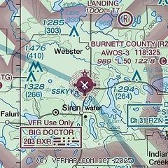
| Sectional chart |
|---|
|
| Airport distance calculator |
|---|
|
|
| Sunrise and sunset |
|---|
|
Times for 20-May-2026
| | Local
(UTC-5) | | Zulu
(UTC) |
|---|
| Morning civil twilight | | 04:58 | | 09:58 |
| Sunrise | | 05:33 | | 10:33 |
| Sunset | | 20:39 | | 01:39 |
| Evening civil twilight | | 21:14 | | 02:14 |
|
| Current date and time |
|---|
| Zulu (UTC) | 20-May-2026 20:06:07 |
|---|
| Local (UTC-5) | 20-May-2026 15:06:07 |
|---|
|
| METAR |
|---|
| KRZN | 201955Z AUTO 01004KT 10SM CLR 13/M02 A3030 RMK AO2 T01331022
|
|
| TAF |
|---|
KHYR
40nm E | 201726Z 2018/2118 VRB05KT P6SM BKN050 FM211200 15006KT P6SM FEW250
|
KRNH
41nm S | 201720Z 2018/2118 36005KT P6SM SCT040 FM210200 VRB03KT P6SM SCT250 FM211500 14009KT P6SM SCT150
|
|
| NOTAMs |
|---|
NOTAMs are issued by the DoD/FAA and will open in a separate window not controlled by AirNav.
|
|

