FAA INFORMATION EFFECTIVE 09 JULY 2026
Location
| FAA Identifier: | SAF |
| Lat/Long: | 35-37-01.6000N 106-05-21.9000W
35-37.026667N 106-05.365000W
35.6171111,-106.0894167
(estimated) |
| Elevation: | 6348.7 ft. / 1935.1 m (surveyed) |
| Variation: | 08E (2020) |
| From city: | 9 miles SW of SANTA FE, NM |
| Time zone: | UTC -6 (UTC -7 during Standard Time) |
| Zip code: | 87505 |
Airport Operations
| Airport use: | Open to the public |
| Activation date: | 06/1942 |
| Control tower: | yes |
| ARTCC: | ALBUQUERQUE CENTER |
| FSS: | ALBUQUERQUE FLIGHT SERVICE STATION |
| NOTAMs facility: | SAF (NOTAM-D service available) |
| Attendance: | 0600-2200
AFT HR SVC - 505-577-7256 OR 505-471-2255. |
| Pattern altitude: | R/W TFC PAT ALT 7000 FT MSL. |
| Wind indicator: | lighted |
| Segmented circle: | yes |
| Lights: | WHEN ATCT CLSD ACTVT MIRL RWY 02/20, 15/33 - CTAF; MIRL RWY 02/20 PRESET LOW INTST; INCR INTST - CTAF. |
| Beacon: | white-green (lighted land airport)
Operates sunset to sunrise. |
| Fire and rescue: | ARFF index B |
| Airline operations: | 24 HR PPR FOR ACR OPS WITH MORE THAN 30 PAX SEATS - 505-955-2900. ARFF INDEX B AVBL ON REQ. |
Airport Communications
| CTAF: | 119.5 |
| UNICOM: | 122.95 |
| ATIS: | 128.55 |
| WX ASOS: | PHONE 505-474-3117 |
| SANTA FE GROUND: | 121.7 [0700-2100] |
| SANTA FE TOWER: | 119.5 239.3 [0700-2100] |
| EMERG: | 121.5 243.0 |
| WX AWOS-3 at LAM (18 nm NW): | 124.175 (505-662-8423) |
- APCH/DEP SVC PRVDD BY ALBUQUERQUE ARTCC (ZAB) ON FREQS 132.8/346.35 (SANDIA MOUNTAIN RCAG).
Nearby radio navigation aids
| VOR radial/distance | | VOR name | | Freq | | Var |
|---|
| SAFr332/4.7 | | SANTA FE VORTAC | | 110.60 | | 13E |
| OTOr334/(33.5) | | OTTO VOR | | 114.45 | | 13E |
Airport Services
| Fuel available: | 100LL JET-A JET-A+ |
| Parking: | hangars and tiedowns |
| Airframe service: | MAJOR |
| Powerplant service: | MAJOR |
| Bottled oxygen: | HIGH/LOW |
| Bulk oxygen: | HIGH/LOW |
Runway Information
Runway 2/20
| Dimensions: | 8366 x 150 ft. / 2550 x 46 m |
| Surface: | asphalt/porous friction courses, in poor condition |
| Weight bearing capacity: | | Single wheel: | 116.0 | | Double wheel: | 164.0 | | Double tandem: | 269.0 |
|
| Runway edge lights: | medium intensity
MIDFIELD LGT COLORED. |
| RUNWAY 2 | | RUNWAY 20 |
| Latitude: | 35-36.500900N | | 35-37.628448N |
| Longitude: | 106-05.770457W | | 106-04.799233W |
| Elevation: | 6273.3 ft. | | 6348.0 ft. |
| Traffic pattern: | left | | left |
| Runway heading: | 027 magnetic, 035 true | | 207 magnetic, 215 true |
| Markings: | precision, in good condition | | precision, in good condition |
| Visual slope indicator: | 4-box VASI on left (3.00 degrees glide path) | | 4-box VASI on left (3.00 degrees glide path) |
| Runway end identifier lights: | | | yes |
| Touchdown point: | yes, no lights | | yes, no lights |
| Instrument approach: | ILS/DME | | |
| Obstructions: | 6 ft. hill, 225 ft. from runway, 226 ft. left of centerline, 4:1 slope to clear | | none |
Runway 15/33
| Dimensions: | 6316 x 100 ft. / 1925 x 30 m |
| Surface: | asphalt/grooved, in excellent condition |
| Weight bearing capacity: | | Single wheel: | 28.0 | | Double wheel: | 43.5 |
|
| Runway edge lights: | medium intensity |
| RUNWAY 15 | | RUNWAY 33 |
| Latitude: | 35-37.465918N | | 35-36.453052N |
| Longitude: | 106-05.493600W | | 106-05.200385W |
| Elevation: | 6319.1 ft. | | 6272.9 ft. |
| Traffic pattern: | left | | left |
| Runway heading: | 159 magnetic, 167 true | | 339 magnetic, 347 true |
| Declared distances: | TORA:6316 TODA:6316 ASDA:5221 LDA:5221 | | |
| Markings: | nonprecision, in good condition | | nonprecision, in good condition |
| Visual slope indicator: | | | 4-box VASI on right (3.00 degrees glide path) |
| Runway end identifier lights: | yes | | yes |
| Touchdown point: | yes, no lights | | yes, no lights |
Runway 10/28
| Dimensions: | 6301 x 75 ft. / 1921 x 23 m |
| Surface: | asphalt/porous friction courses, in good condition |
| Weight bearing capacity: | |
| RUNWAY 10 | | RUNWAY 28 |
| Latitude: | 35-37.233652N | | 35-36.849895N |
| Longitude: | 106-06.082502W | | 106-04.901112W |
| Elevation: | 6281.2 ft. | | 6298.2 ft. |
| Traffic pattern: | left | | left |
| Runway heading: | 104 magnetic, 112 true | | 284 magnetic, 292 true |
| Markings: | nonprecision, in good condition | | nonprecision, in good condition |
| Runway end identifier lights: | yes | | |
| Touchdown point: | yes, no lights | | yes, no lights |
| Obstructions: | none | | 11 ft. road, 250 ft. from runway, 260 ft. right of centerline, 4:1 slope to clear |
Helipad H1
| Dimensions: | 40 x 40 ft. / 12 x 12 m |
| Surface: | concrete |
| Latitude: | 35-36.933833N | | |
| Longitude: | 106-04.877333W | | |
| Elevation: | 6311.0 ft. | | |
| Traffic pattern: | left | | left |
Airport Ownership and Management from official FAA records
| Ownership: | Publicly-owned |
| Owner: | CITY OF SANTA FE
PO BOX 909
SANTA FE, NM 87504-0909
Phone 505-955-2910 |
| Manager: | JIMMY GUNN
121 AVIATION DR
SANTA FE, NM 87507-0909
Phone 505-955-2910
AMGR: 505-955-2910, 505-955-2903. |
Additional Remarks
| A39-02/20 | PCR VALUE: 170/F/D/X/T |
| A39-10/28 | PCR VALUE: 80/F/D/X/T |
| A39-15/33 | PCR VALUE: 80/F/D/X/T |
| - | RNG ON FLD. |
| - | NOISE ABATEMENT PROC - AMGR. |
| - | FOR CD IF UNA TO CTC ON FSS FREQ, CTC ALBUQUERQUE ARTCC AT 505-856-4561. |
Instrument Procedures
NOTE: All procedures below are presented as PDF files. If you need a reader for these files, you should download the free Adobe Reader.NOT FOR NAVIGATION. Please procure official charts for flight.
FAA instrument procedures published for use from 09 July 2026 at 0901Z to 06 August 2026 at 0900Z.
IAPs - Instrument Approach Procedures |
|---|
| ILS OR LOC RWY 02 | |
download (291KB) |
| RNAV (GPS) RWY 02 | |
download (259KB) |
| RNAV (GPS) RWY 15 | |
download (370KB) |
| RNAV (GPS) RWY 20 | |
download (559KB) |
| RNAV (GPS) RWY 28 | |
download (296KB) |
| RNAV (GPS) RWY 33 | |
download (308KB) |
| VOR/DME-A | |
download (317KB) |
| VOR RWY 33 | |
download (299KB) |
| NOTE: Special Alternate Minimums apply | |
download (144KB) |
Departure Procedures |
|---|
| POAKE TWO | |
download (190KB) |
| TAFOY THREE | |
download (231KB) |
| ZIASE FIVE | |
download (207KB) |
| NOTE: Special Take-Off Minimums/Departure Procedures apply | |
download (293KB) |
Other nearby airports with instrument procedures:
KLAM - Los Alamos Airport (18 nm NW)
0E0 - Moriarty Municipal Airport (39 nm S)
KABQ - Albuquerque International Sunport Airport (43 nm SW)
KAEG - Double Eagle II Airport (45 nm SW)
KLVS - Las Vegas Municipal Airport (46 nm E)
|
|

Road maps at:
MapQuest
Bing
Google
| Aerial photo |
|---|
WARNING: Photo may not be current or correct
 Photo by Lee Morgan
Photo taken 22-Jun-2010
Photo by Lee Morgan
Photo taken 22-Jun-2010
Do you have a better or more recent aerial photo of Santa Fe Regional Airport that you would like to share? If so, please send us your photo.
|
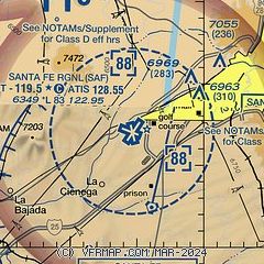
| Sectional chart |
|---|
|
CAUTION: Diagram may not be current

| Airport distance calculator |
|---|
|
|
| Sunrise and sunset |
|---|
|
Times for 22-Jul-2026
| | Local
(UTC-6) | | Zulu
(UTC) |
|---|
| Morning civil twilight | | 05:37 | | 11:37 |
| Sunrise | | 06:06 | | 12:06 |
| Sunset | | 20:16 | | 02:16 |
| Evening civil twilight | | 20:44 | | 02:44 |
|
| Current date and time |
|---|
| Zulu (UTC) | 22-Jul-2026 23:15:00 |
|---|
| Local (UTC-6) | 22-Jul-2026 17:15:00 |
|---|
|
| METAR |
|---|
| KSAF | 222253Z 30008KT 10SM TSRA FEW050 BKN095 OVC110 18/16 A3025 RMK AO2 PK WND 21044/2223 WSHFT 2218 LTG DSNT N AND S AND W SLP159 P0032 T01830156
|
KLAM
17nm NW | 222255Z AUTO 13011G17KT 100V170 10SM SCT070 BKN110 28/10 A3029 RMK AO2 T02780105 $
|
|
| TAF |
|---|
| KSAF | 222218Z 2222/2318 20011G19KT P6SM BKN100 TEMPO 2222/2301 VRB15G25KT 3SM -TSRA SCT040 BKN080CB FM230200 17007KT P6SM BKN090 FM230600 VRB05KT P6SM SCT100
|
|
| NOTAMs |
|---|
NOTAMs are issued by the DoD/FAA and will open in a separate window not controlled by AirNav.
|
|


