FAA INFORMATION EFFECTIVE 22 JANUARY 2026
Location
| FAA Identifier: | AEG |
| Lat/Long: | 35-08-41.6740N 106-47-42.6260W
35-08.694567N 106-47.710433W
35.1449094,-106.7951739
(estimated) |
| Elevation: | 5837.4 ft. / 1779.2 m (surveyed) |
| Variation: | 11E (1990) |
| From city: | 7 miles NW of ALBUQUERQUE, NM |
| Time zone: | UTC -7 (UTC -6 during Daylight Saving Time) |
| Zip code: | 87121 |
Airport Operations
| Airport use: | Open to the public |
| Activation date: | 08/1983 |
| Control tower: | yes |
| ARTCC: | ALBUQUERQUE CENTER |
| FSS: | ALBUQUERQUE FLIGHT SERVICE STATION |
| NOTAMs facility: | AEG (NOTAM-D service available) |
| Attendance: | 0600-1900
FOR ATTENDANT AFT HRS CALL 505-884-4530. |
| Wind indicator: | lighted |
| Segmented circle: | yes |
| Lights: | ACTVT MALSR RWY 22; REIL RWY 17 & 35; PAPI RWY 04 & 17; MIRL RWY 04/22 & 17/35 - CTAF. |
| Beacon: | white-green (lighted land airport)
Operates sunset to sunrise. |
Airport Communications
| CTAF: | 120.15 |
| ATIS: | 119.025 |
| WX AWOS-3PT: | PHONE 505-842-2009 |
| DOUBLE EAGLE II GROUND: | 121.625 [0600-2200] |
| DOUBLE EAGLE II TOWER: | 120.15 [0600-2200] |
| ALBUQUERQUE APPROACH: | 127.4 |
| ALBUQUERQUE DEPARTURE: | 127.4 |
| CLEARANCE DELIVERY: | 124.8 ;WHEN TWR CLSD |
| CURLY STAR: | 127.4 |
| LAVAN STAR: | 123.9 |
| MIERA STAR: | 123.9 |
| WX ASOS at ABQ (11 nm SE): | PHONE 505-373-2492 |
Nearby radio navigation aids
| VOR radial/distance | | VOR name | | Freq | | Var |
|---|
| ABQr357/6.2 | | ALBUQUERQUE VORTAC | | 113.20 | | 13E |
| NDB name | | Hdg/Dist | | Freq | | Var | | ID |
|---|
| DUDLE | | 212/5.9 | | 351 | | 11E | | AE | .- . |
Airport Services
| Fuel available: | 100LL JET-A1
100LL:100LL AVBL 24 HRS SELF-SERVICE WITH MAJOR CREDIT CARD.
A1:$150 CALL-OUT FEE FOR JET A1. |
| Parking: | hangars and tiedowns |
| Airframe service: | MAJOR |
| Powerplant service: | MAJOR |
| Bottled oxygen: | HIGH |
| Bulk oxygen: | HIGH |
Runway Information
Runway 4/22
| Dimensions: | 7398 x 100 ft. / 2255 x 30 m |
| Surface: | asphalt/porous friction courses, in good condition |
| Weight bearing capacity: | | PCN 16 /F/C/X/T | | Single wheel: | 30.0 |
|
| Runway edge lights: | medium intensity |
| RUNWAY 4 | | RUNWAY 22 |
| Latitude: | 35-08.324985N | | 35-09.169178N |
| Longitude: | 106-48.550843W | | 106-47.479872W |
| Elevation: | 5837.4 ft. | | 5810.1 ft. |
| Traffic pattern: | left | | right |
| Runway heading: | 035 magnetic, 046 true | | 215 magnetic, 226 true |
| Markings: | precision, in good condition | | precision, in good condition |
| Visual slope indicator: | 4-light PAPI on left (3.00 degrees glide path) | | |
| Approach lights: | | | MALSR: 1,400 foot medium intensity approach lighting system with runway alignment indicator lights |
| Touchdown point: | yes, no lights | | yes, no lights |
| Instrument approach: | | | ILS |
Runway 17/35
| Dimensions: | 5983 x 100 ft. / 1824 x 30 m |
| Surface: | asphalt, in excellent condition |
| Weight bearing capacity: | | PCN 11 /F/D/X/T | | Single wheel: | 30.0 |
|
| Runway edge lights: | medium intensity |
| RUNWAY 17 | | RUNWAY 35 |
| Latitude: | 35-09.122607N | | 35-08.136582N |
| Longitude: | 106-47.333863W | | 106-47.332805W |
| Elevation: | 5805.9 ft. | | 5798.2 ft. |
| Traffic pattern: | left | | right |
| Runway heading: | 169 magnetic, 180 true | | 349 magnetic, 360 true |
| Markings: | nonprecision, in good condition | | nonprecision, in good condition |
| Visual slope indicator: | 4-light PAPI on left (3.00 degrees glide path) | | |
| Runway end identifier lights: | yes | | yes |
| Touchdown point: | yes, no lights | | yes, no lights |
Airport Ownership and Management from official FAA records
| Ownership: | Publicly-owned |
| Owner: | CITY OF ALBUQUERQUE
PO BOX 9948
ALBUQUERQUE, NM 87119
Phone (505) 244-7888 |
| Manager: | GAVINO GALLEGOS
PO BOX 9948
ALBUQUERQUE, NM 87119
Phone 505-259-8113 |
Additional Remarks
| - | WILDLIFE ON AND INVOF ARPT. |
| - | LIVE FIRE RANGE 1.6NM WEST OF THE APPROACH END OF RWY 04 AVOIDANCE ADVISED. |
Instrument Procedures
NOTE: All procedures below are presented as PDF files. If you need a reader for these files, you should download the free Adobe Reader.NOT FOR NAVIGATION. Please procure official charts for flight.
FAA instrument procedures published for use from 22 January 2026 at 0901Z to 19 February 2026 at 0900z.
STARs - Standard Terminal Arrivals |
|---|
| CURLY THREE | |
download (138KB) |
| FRIHO FOUR | |
download (133KB) |
| LAVAN THREE | |
download (153KB) |
| MIERA TWO | |
download (200KB) |
IAPs - Instrument Approach Procedures |
|---|
| ILS OR LOC RWY 22 | |
download (301KB) |
| RNAV (GPS) RWY 04 | |
download (285KB) |
| RNAV (GPS) RWY 22 | |
download (309KB) |
| NOTE: Special Alternate Minimums apply | |
download (37KB) |
| NOTE: Special Take-Off Minimums/Departure Procedures apply | |
download (105KB) |
Other nearby airports with instrument procedures:
KABQ - Albuquerque International Sunport Airport (11 nm SE)
KBRG - Belen Regional Airport (30 nm S)
0E0 - Moriarty Municipal Airport (40 nm E)
KSAF - Santa Fe Regional Airport (45 nm NE)
KLAM - Los Alamos Airport (51 nm NE)
|
|

Road maps at:
MapQuest
Bing
Google
| Aerial photo |
|---|
WARNING: Photo may not be current or correct
 Photo by Lee Morgan
Photo taken 07-Sep-2019
looking south-southwest.
Photo by Lee Morgan
Photo taken 07-Sep-2019
looking south-southwest.
Do you have a better or more recent aerial photo of Double Eagle II Airport that you would like to share? If so, please send us your photo.
|
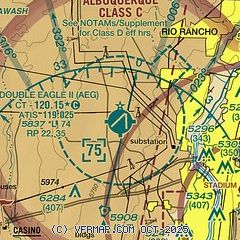
| Sectional chart |
|---|
|
CAUTION: Diagram may not be current

| Airport distance calculator |
|---|
|
|
| Sunrise and sunset |
|---|
|
Times for 28-Jan-2026
| | Local
(UTC-7) | | Zulu
(UTC) |
|---|
| Morning civil twilight | | 06:43 | | 13:43 |
| Sunrise | | 07:10 | | 14:10 |
| Sunset | | 17:30 | | 00:30 |
| Evening civil twilight | | 17:57 | | 00:57 |
|
| Current date and time |
|---|
| Zulu (UTC) | 28-Jan-2026 19:49:39 |
|---|
| Local (UTC-7) | 28-Jan-2026 12:49:39 |
|---|
|
| METAR |
|---|
| KAEG | 281847Z 14005KT 10SM CLR 08/M13 A3037
|
KABQ
10nm SE | 281852Z 00000KT 10SM FEW250 SCT300 07/M10 A3037 RMK AO2 SLP283 T00721100 $
|
|
| TAF |
|---|
| KAEG | 281722Z 2818/2918 18005KT P6SM SCT250 FM290300 31007KT P6SM BKN200 FM291000 32013KT P6SM SCT200
|
KABQ
10nm SE | 281722Z 2818/2918 VRB05KT P6SM SCT250 FM290600 35008KT P6SM BKN200
|
|
| NOTAMs |
|---|
NOTAMs are issued by the DoD/FAA and will open in a separate window not controlled by AirNav.
|
|


