FAA INFORMATION EFFECTIVE 11 JUNE 2026
Location
| FAA Identifier: | SEA |
| Lat/Long: | 47-26-59.6000N 122-18-42.4000W
47-26.993333N 122-18.706667W
47.4498889,-122.3117778
(estimated) |
| Elevation: | 432.3 ft. / 131.8 m (surveyed) |
| Variation: | 16E (2020) |
| From city: | 10 miles S of SEATTLE, WA |
| Time zone: | UTC -7 (UTC -8 during Standard Time) |
| Zip code: | 98188 |
Airport Operations
| Airport use: | Open to the public |
| Activation date: | 01/1944 |
| Control tower: | yes |
| ARTCC: | SEATTLE CENTER |
| FSS: | SEATTLE FLIGHT SERVICE STATION |
| NOTAMs facility: | SEA (NOTAM-D service available) |
| Attendance: | CONTINUOUS |
| Wind indicator: | lighted |
| Segmented circle: | no |
| Lights: | SS-SR |
| Beacon: | white-green (lighted land airport)
Operates sunset to sunrise. |
| Landing fee: | yes |
| Fire and rescue: | ARFF index E |
| International operations: | customs landing rights airport |
Airport Communications
| UNICOM: | 122.95 |
| WX ASOS: | PHONE 206-214-2592 |
| SEATTLE GROUND: | 121.7 |
| SEATTLE TOWER: | 119.9 ;RWY 16L/34R, 16C/34C 120.95 ;RWY 16R/34L 239.3 ;RWY 16L/34R, 16C/34C 239.3 ;RWY 16R/34L |
| SEATTLE APPROACH: | 119.2 ;017-079 SEA RWY 34 119.2 ;028-160 SEA RWY 16 120.1 ;223-289 SEA, RWY 16 120.1 ;223-301 SEA, RWY 34 120.4 ;301-340 SEA, RWY 34 125.6 ;ARR WEST 125.9 ;080-125 SEA, RWY 34 125.9 ;290-315 SEA, RWY 16 126.5 ;126-222 SEA, RWY 34 126.5 ;161-222 SEA, RWY 16 128.5 ;302-016 SEA, RWY 34 128.5 ;316-027 SEA, RWY 16 133.65 ;RWY 16/34 123.9 |
| SEATTLE DEPARTURE: | 119.2 ;028-160 SEA RWY 16 120.1 ;223-289 SEA, RWY 16 120.1 ;223-301 SEA, RWY 34 120.4 ;301-340 SEA, RWY 34 125.6 ;ARR WEST 125.9 ;080-125 SEA, RWY 34 125.9 ;290-315 SEA, RWY 16 126.5 ;126-222 SEA, RWY 34 126.5 ;161-222 SEA, RWY 16 128.5 ;302-016 SEA, RWY 34 128.5 ;316-027 SEA, RWY 16 123.9 |
| CLEARANCE DELIVERY: | 128.0 |
| ATOME DP: | 120.4 |
| BANGR RNAV DP: | 120.4 |
| CHINS STAR: | 123.9 |
| CLASS B: | 119.2 ;017-079 SEA, RWY 34 119.2 ;028-160 SEA RWY 16 120.1 ;223-289 SEA, RWY 16 120.1 ;223-301 SEA, RWY 34 120.4 ;301-340 SEA, RWY 34 125.9 ;080-125 SEA, RWY 34 125.9 ;290-315 SEA RWY 16 126.5 ;126-222 SEA, RWY 34 126.5 ;161-222 SEA, RWY 16 128.5 ;302-016 SEA, RWY 34 128.5 ;316-027 SEA RWY 16 |
| D-ATIS: | 118.0 |
| DE/P: | 119.2 ;017-079 SEA RWY 34 |
| ELMAA DP: | 120.4 |
| EMERG: | 121.5 243.0 |
| FINAL: | 133.65 ;RWY 16/34 |
| GLASR STAR: | 123.9 |
| HAROB RNAV DP: | 120.4 |
| HAWKZ RNAV STAR: | 125.6 |
| IC: | 133.65 ;RWY 16/34 |
| ISBRG DP: | 120.4 |
| JAWBN STAR: | 125.6 |
| JEFPO DP: | 120.4 |
| MARNR RNAV STAR: | 125.6 |
| MOUNTAIN DP: | 119.2 |
| OLYMPIA STAR: | 125.6 |
| OZWLD RNAV DP: | 120.4 |
| RAMP CTL: | 122.275 ;SOUTH RAMP 126.25 ;GATE HOLD 126.875 ;NORTH RAMP |
| SEATTLE DP: | 119.2 |
| SKYKO STAR: | 123.9 |
| SUMMA DP: | 119.2 ;RWY 34L/C/R, NORTH 120.4 ;RWY 16L/C/R, SOUTH |
| WX ASOS at RNT (5 nm NE): | 126.95 (425-255-6080) |
| WX ASOS at BFI (5 nm N): | PHONE 206-658-6435 |
| WX ASOS at TIW (15 nm SW): | PHONE 253-858-6507 |
| WX AWOS-3PT at PWT (19 nm W): | 121.2 (360-674-2811) |
| WX ASOS at TCM (20 nm S): | PHONE 253-982-3434 |
- FREQ SECTORS FLOAT DEPENDING ON RY IN USE AND SECTORS GENERALLY APPLY TO SEATTLE TCA.
- ASDE-X IN USE. OPERATE TRANSPONDERS WITH ALTITUDE REPORTING MODE AND ADS-B (IF EQUIPPED) ENABLED ON ALL AIRPORT SURFACES.
Nearby radio navigation aids
| VOR radial/distance | | VOR name | | Freq | | Var |
|---|
| SEA at field | | SEATTLE VORTAC | | 116.80 | | 19E |
| PAEr163/28.2 | | PAINE VOR/DME | | 110.60 | | 20E |
| OLMr021/37.4 | | OLYMPIA VORTAC | | 113.40 | | 19E |
Airport Services
| Fuel available: | A JET-A1 |
| Parking: | tiedowns |
| Airframe service: | NONE |
| Powerplant service: | NONE |
| Bottled oxygen: | NONE |
| Bulk oxygen: | NONE |
Runway Information
Runway 16L/34R
| Dimensions: | 11901 x 150 ft. / 3627 x 46 m |
| Surface: | concrete/grooved, in excellent condition |
| Weight bearing capacity: | | Single wheel: | 120.0 | | Double wheel: | 250.0 | | Double tandem: | 550.0 | | Dual double tandem: | 1120.0 |
|
| Runway edge lights: | high intensity |
| RUNWAY 16L | | RUNWAY 34R |
| Latitude: | 47-27.827713N | | 47-25.870337N |
| Longitude: | 122-18.465013W | | 122-18.482295W |
| Elevation: | 432.3 ft. | | 346.7 ft. |
| Traffic pattern: | left | | left |
| Runway heading: | 164 magnetic, 180 true | | 344 magnetic, 000 true |
| Declared distances: | TORA:11901 TODA:11901 ASDA:11901 LDA:11901 | | TORA:11901 TODA:11901 ASDA:11901 LDA:11901 |
| Markings: | precision, in good condition | | precision, in good condition |
| Visual slope indicator: | 4-light PAPI on left (3.00 degrees glide path) | | 4-light PAPI on left (2.75 degrees glide path) |
| RVR equipment: | touchdown, midfield, rollout | | touchdown, midfield, rollout |
| Approach lights: | ALSF2: standard 2,400 foot high intensity approach lighting system with centerline sequenced flashers (category II or III) | | MALSR: 1,400 foot medium intensity approach lighting system with runway alignment indicator lights |
| Centerline lights: | yes | | yes |
| Touchdown point: | yes, lighted | | yes, lighted |
| Instrument approach: | ILS/DME | | ILS/DME |
Runway 16C/34C
| Dimensions: | 9426 x 150 ft. / 2873 x 46 m |
| Surface: | concrete/grooved, in excellent condition |
| Weight bearing capacity: | | Single wheel: | 120.0 | | Double wheel: | 250.0 | | Double tandem: | 550.0 | | Dual double tandem: | 1111.0 |
|
| Runway edge lights: | high intensity |
| RUNWAY 16C | | RUNWAY 34C |
| Latitude: | 47-27.828592N | | 47-26.278277N |
| Longitude: | 122-18.659025W | | 122-18.672590W |
| Elevation: | 429.4 ft. | | 362.9 ft. |
| Traffic pattern: | left | | left |
| Runway heading: | 164 magnetic, 180 true | | 344 magnetic, 000 true |
| Declared distances: | TORA:9426 TODA:9426 ASDA:9426 LDA:9426 | | TORA:9426 TODA:9426 ASDA:9426 LDA:9426 |
| Markings: | precision, in good condition | | precision, in good condition |
| Visual slope indicator: | 4-light PAPI on left (3.00 degrees glide path) | | 4-light PAPI on left (3.00 degrees glide path) |
| RVR equipment: | touchdown, midfield, rollout | | touchdown, midfield, rollout |
| Approach lights: | ALSF2: standard 2,400 foot high intensity approach lighting system with centerline sequenced flashers (category II or III) | | MALSR: 1,400 foot medium intensity approach lighting system with runway alignment indicator lights |
| Centerline lights: | yes | | yes |
| Touchdown point: | yes, lighted | | yes, no lights |
| Instrument approach: | ILS/DME | | ILS/DME |
Runway 16R/34L
| Dimensions: | 8500 x 150 ft. / 2591 x 46 m |
| Surface: | concrete/grooved, in excellent condition |
| Weight bearing capacity: | | Single wheel: | 120.0 | | Double wheel: | 250.0 | | Double tandem: | 482.0 | | Dual double tandem: | 1007.0, TDT 817 |
|
| Runway edge lights: | high intensity |
| RUNWAY 16R | | RUNWAY 34L |
| Latitude: | 47-27.830182N | | 47-26.432028N |
| Longitude: | 122-19.071410W | | 122-19.083483W |
| Elevation: | 414.8 ft. | | 356.2 ft. |
| Traffic pattern: | left | | left |
| Runway heading: | 164 magnetic, 180 true | | 344 magnetic, 000 true |
| Declared distances: | TORA:8500 TODA:8500 ASDA:8500 LDA:8500 | | TORA:8500 TODA:8500 ASDA:8500 LDA:8500 |
| Markings: | precision, in good condition | | precision, in good condition |
| Visual slope indicator: | 4-light PAPI on right (3.00 degrees glide path) | | 4-light PAPI on left (3.00 degrees glide path) |
| RVR equipment: | touchdown, midfield, rollout | | touchdown, midfield, rollout |
| Approach lights: | ALSF2: standard 2,400 foot high intensity approach lighting system with centerline sequenced flashers (category II or III) | | MALSR: 1,400 foot medium intensity approach lighting system with runway alignment indicator lights |
| Centerline lights: | yes | | yes |
| Touchdown point: | yes, lighted | | yes, no lights |
| Instrument approach: | ILS/DME | | ILS/DME |
Airport Ownership and Management from official FAA records
| Ownership: | Publicly-owned |
| Owner: | PORT OF SEATTLE
BOX 1209
SEATTLE, WA 98111
Phone 206-787-3000 |
| Manager: | WENDY REITER
BOX 68727
SEATTLE, WA 98168
Phone (206) 787-5229 |
Additional Remarks
| A39-16L/34R | PCR VALUE: 1147/R/B/W/T |
| A39-16R/34L | PCR VALUE: 866/R/B/W/T |
| A39-16C/34C | PCR VALUE: 1002/R/B/W/T |
| E110 | CONTINUOUS POWER ARPT. |
| E94 | WSO/WSFO. |
| - | BIRD FLOCKS ON AND INVOF ARPT - CHECK LCL ADZYS. |
| - | TWY A SOUTH OF TWY G RSTD TO ACFT WITH WINGSPAN 225 FT OR LESS. |
| - | DO NOT MISTAKE TWY T FOR LDG SFC. |
| - | ACES TO AIR CARGO 4 PRKG AND CARGO AREAS RSTD TO ACFT WITH WINGSPAN 170 FT OR LESS. |
| - | TWY FOR CORPORATE HNGR RAMP RSTD TO ACFT WITH WINGSPAN 62 FT OR LESS FOR TAXI OPS. GA CUST PRKG IS VERY LTD. |
| - | PPR FOR ALL GA PRKG AND SVCS;, CTC 206-433-5481. OPER HRS 0700L - 2100L, WITH A CALL OUT AVBL UPON REQ. |
| - | TXL W RSTRD TO ACFT WITH WINGSPAN 135 FT OR LESS NORTH OF TWY N AND 167 FT OR LESS SOUTH OF TWY N. SEATTLE RAMP TWR PRVDS ADZY CTL ONLY. |
| - | GA LDG FEES PAYABLE BY MAJOR CREDIT CARDS ONLY. |
| - | TXL ON NORTH SIDE OF TWY N STLT RSTD TO ACFT WITH WINGSPAN 118 FT OR LESS. TRI-TXL'S AT NORTH STLT: CNTR (GREEN) TXL RSTD TO ACFT WITH WINGSPAN 135 FT OR LESS. WHEN AN ACFT IS ON THE CNTR (GREEN) OR OTR (ORANGE/BLUE) TXL'S, NO OTR ACFT CAN SIMUL USE THE ADJ TXL(S). ORANGE & BLUE TXL'S ARE RSTD TO ACFT WITH WINGSPAN 118 FT OR LESS. TWO ACFT CAN SIMUL USE THE OUTER TXL'S. |
| - | RY STATUS LGTS ARE IN OPN. |
| - | ACFT WITH WINGSPAN OF 171 FT. OR MORE PRKD AT PAX GATES OR CARGO 7 MUST PROVD 30 MIN PPR PRIOR TO PUSHBACK TO SEATTLE RAMP TWR WHEN VIS LESS THAN 2400 RVR. |
| - | TWY J EAST OF TWY T RSTD TO ACFT WITH WINGSPAN 118 FT OR LESS. |
| - | RWY 16L/34R RSTD TO ACFT WITH WINGSPAN 260 FT OR LESS. |
| - | FLIGHT NOTIFICATION SERVICE (ADCUS) AVBL. |
| - | TWY H RSTRD TO ACFT WITH WINGSPAN 118 FT OR LESS. |
| - | TWY B SOUTH OF TWY S RSTRD TO ACFT WITH WINGSPAN 260 FT OR LESS. |
| - | AIR CARGO 5 RAMP DUAL ENG TAX ONLY |
| - | 100LL FUEL NOT AVBL. |
| - | THE USE OF REVERSE THRUST BYD WHAT IS NEC FOR OPNL OR SAFETY RSNS IS DISCOURAGED AT ALL TIMES. NOISE ABATEMENT FLT PROCS IN EFCT BTN 2200-0600. FOR FURTHER INFO CTC SEA NOISE ABATEMENT OFC AT 206-787-5393. |
| - | CONS TAXI TO TAKEOFF AT SEA. WHEN PRACTICAL, SAFE AND AVBL, CONS TAXI TO TAKEOFFS ARE ENCOURAGED. CONS TAXI TO TAKEOFFS MAY RDC ACFT NOISE WI NEARBY COMMUNITIES. |
| - | RPRT BIRD STRIKES TO 206-787-7233 |
| - | SOUTH SATELLITE TXL RSTRD TO ACFT WITH WINGSPAN OF 214 FT OR LESS. |
| - | CARGO1 RSTRD TO ACFT WITH WINGSPAN OF 170 FT OR LESS. |
| - | TO MINIMIZE NOISE, FUEL BURN AND JET BLAST, OPERATORS ARE ADVISED TO USE THE MNM RQRD THRUST WHEN TAXIING INVOF THE TRML OR ACFT PRKG AREAS. |
| - | HELICOPTERS LANDING & DEPARTING AVOID OVERFLYING FUEL FARM LCTD AT THE SE CORNER OF THE ARPT. |
Instrument Procedures
NOTE: All procedures below are presented as PDF files. If you need a reader for these files, you should download the free Adobe Reader.NOT FOR NAVIGATION. Please procure official charts for flight.
FAA instrument procedures published for use from 11 June 2026 at 0901Z to 09 July 2026 at 0900z.
STARs - Standard Terminal Arrivals |
|---|
| CHINS FIVE **NEW** | |
2 pages:
[1] [2] (344KB) |
| GLASR THREE **NEW** | |
2 pages:
[1] [2] (366KB) |
| HAWKZ EIGHT (RNAV) **NEW** | |
2 pages:
[1] [2] (465KB) |
| JAWBN SEVEN **NEW** | |
download (195KB) |
| MARNR EIGHT (RNAV) **NEW** | |
2 pages:
[1] [2] (442KB) |
| OLYMPIA TWO **NEW** | |
2 pages:
[1] [2] (303KB) |
| SKYKO ONE **NEW** | |
download (232KB) |
IAPs - Instrument Approach Procedures |
|---|
| ILS OR LOC RWY 16C | |
2 pages:
[1] [2] (626KB) |
| ILS OR LOC RWY 16L | |
download (420KB) |
| ILS OR LOC RWY 16R | |
download (444KB) |
| ILS OR LOC RWY 34C | |
download (387KB) |
| ILS OR LOC RWY 34L | |
download (385KB) |
| ILS OR LOC RWY 34R | |
download (422KB) |
| ILS RWY 16C (SA CAT I) | |
download (421KB) |
| ILS RWY 16L (SA CAT I) | |
download (406KB) |
| ILS RWY 16R (SA CAT I) | |
download (431KB) |
| ILS RWY 34C (SA CAT I - II) | |
download (383KB) |
| ILS RWY 34L (SA CAT I - II) | |
download (382KB) |
| ILS RWY 34R (SA CAT I - II) | |
download (397KB) |
| ILS RWY 16C (CAT II - III) | |
download (435KB) |
| ILS RWY 16L (CAT II - III) | |
download (427KB) |
| ILS RWY 16R (CAT II - III) | |
download (448KB) |
| RNAV (RNP) Z RWY 16C | |
2 pages:
[1] [2] (508KB) |
| RNAV (RNP) Z RWY 16L | |
download (304KB) |
| RNAV (RNP) Z RWY 16R | |
download (339KB) |
| RNAV (RNP) Z RWY 34C | |
download (280KB) |
| RNAV (RNP) Z RWY 34L | |
download (305KB) |
| RNAV (RNP) Z RWY 34R | |
download (285KB) |
| RNAV (GPS) Y RWY 16C | |
2 pages:
[1] [2] (475KB) |
| RNAV (GPS) Y RWY 16L | |
download (329KB) |
| RNAV (GPS) Y RWY 16R | |
download (297KB) |
| RNAV (GPS) Y RWY 34C | |
download (312KB) |
| RNAV (GPS) Y RWY 34L | |
download (366KB) |
| RNAV (GPS) Y RWY 34R | |
download (364KB) |
| BAY VISUAL RWY 16 R/C/L | |
2 pages:
[1] [2] (475KB) |
| HUSKY VISUAL RWY 16 R/C/L | |
2 pages:
[1] [2] (431KB) |
| MALL VISUAL RWY 34 R/C/L | |
download (305KB) |
Departure Procedures |
|---|
| BANGR NINE (RNAV) | |
2 pages:
[1] [2] (437KB) |
| ELMAA FIVE | |
download (181KB) |
| ELMAA FIVE | |
download (181KB) |
| HAROB SIX (RNAV) | |
2 pages:
[1] [2] (483KB) |
| ISBRG ONE (RNAV) | |
download (223KB) |
| JEFPO ONE (RNAV) | |
download (246KB) |
| MOUNTAIN TWO | |
2 pages:
[1] [2] (351KB) |
| OZWLD ONE (RNAV) | |
download (252KB) |
| SEATTLE ONE | |
download (252KB) |
| SUMMA TWO | |
2 pages:
[1] [2] (329KB) |
| NOTE: Special Take-Off Minimums/Departure Procedures apply | |
download (455KB) |
Other nearby airports with instrument procedures:
KRNT - Renton Municipal Airport (5 nm NE)
KBFI - Boeing Field/King County International Airport (5 nm N)
S50 - Auburn Municipal Airport (8 nm SE)
KTIW - Tacoma Narrows Airport (15 nm SW)
KPWT - Bremerton National Airport (19 nm W)
KTCM - McChord Field Airport (Joint Base Lewis-McChord) (20 nm S)
|
|

Road maps at:
MapQuest
Bing
Google
| Aerial photo |
|---|
WARNING: Photo may not be current or correct
 Photo by Trent Thomas
Photo taken 22-Aug-2022
facing S/SE at 7,500 MSL.
Photo by Trent Thomas
Photo taken 22-Aug-2022
facing S/SE at 7,500 MSL.
Do you have a better or more recent aerial photo of Seattle-Tacoma International Airport that you would like to share? If so, please send us your photo.
|
| Sectional chart |
|---|
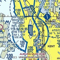
|
 Download PDF
of official airport diagram from the FAA
| Airport distance calculator |
|---|
|
|
| Sunrise and sunset |
|---|
|
Times for 14-Jun-2026
| | Local
(UTC-7) | | Zulu
(UTC) |
|---|
| Morning civil twilight | | 04:32 | | 11:32 |
| Sunrise | | 05:13 | | 12:13 |
| Sunset | | 21:06 | | 04:06 |
| Evening civil twilight | | 21:47 | | 04:47 |
|
| Current date and time |
|---|
| Zulu (UTC) | 14-Jun-2026 07:08:15 |
|---|
| Local (UTC-7) | 14-Jun-2026 00:08:15 |
|---|
|
| METAR |
|---|
| KSEA | 140653Z 01007KT 10SM SCT250 21/08 A3013 RMK AO2 SLP207 T02110083 $
|
KRNT
5nm NE | 140653Z 02004KT 10SM CLR 21/11 A3012 RMK AO2 SLP205 T02060111 $
|
KBFI
6nm N | 140653Z 00000KT 10SM CLR 22/09 A3012 RMK AO2 SLP200 T02170089
|
KTIW
16nm SW | 140653Z AUTO 06004KT 10SM CLR 21/08 A3012 RMK AO2 SLP196 T02060083 402670111
|
KPWT
18nm W | 140656Z AUTO 04008KT 10SM CLR 21/06 A3013 RMK AO2 SLP205 T02110056 PNO $
|
|
| TAF |
|---|
| KSEA | 140520Z 1406/1512 02006KT P6SM SCT250 FM141800 35009KT P6SM FEW250 FM150000 36009KT P6SM FEW250
|
KBFI
6nm N | 140520Z 1406/1506 01005KT P6SM SCT250 FM141000 VRB04KT P6SM FEW250 FM141800 31008KT P6SM FEW250 FM150000 32006KT P6SM FEW250
|
KPWT
18nm W | 140520Z 1406/1506 03006KT P6SM FEW250 FM141800 04008KT P6SM FEW250 FM150300 03006KT P6SM FEW250
|
|
| NOTAMs |
|---|
NOTAMs are issued by the DoD/FAA and will open in a separate window not controlled by AirNav.
|
|


