FAA INFORMATION EFFECTIVE 14 MAY 2026
Location
| FAA Identifier: | S50 |
| Lat/Long: | 47-19-39.4500N 122-13-35.9580W
47-19.657500N 122-13.599300W
47.3276250,-122.2266550
(estimated) |
| Elevation: | 63 ft. / 19.2 m (surveyed) |
| Variation: | 18E (2005) |
| From city: | 1 mile N of AUBURN, WA |
| Time zone: | UTC -7 (UTC -8 during Standard Time) |
| Zip code: | 98002 |
Airport Operations
| Airport use: | Open to the public |
| Activation date: | 03/1970 |
| Control tower: | no |
| ARTCC: | SEATTLE CENTER |
| FSS: | SEATTLE FLIGHT SERVICE STATION |
| NOTAMs facility: | SEA (NOTAM-D service available) |
| Attendance: | MON-FRI 0800-1700 |
| Wind indicator: | lighted |
| Segmented circle: | yes |
| Lights: | ACTVT REIL RWY 17 & 35; MIRL RWY 17/35 - CTAF. PAPI RWY 17 & 35 OPR CONSLY. |
| Beacon: | white-green (lighted land airport)
Operates sunset to sunrise. |
Airport Communications
| CTAF/UNICOM: | 122.975 |
| SEATTLE APPROACH: | 123.85 [0530-0000] |
| SEATTLE DEPARTURE: | 123.85 [0530-0000] |
| CLEARANCE DELIVERY: | 123.85 |
| WX ASOS at SEA (8 nm NW): | PHONE 206-214-2592 |
| WX ASOS at RNT (10 nm N): | 126.95 (425-255-6080) |
| WX ASOS at BFI (13 nm N): | PHONE 206-658-6435 |
| WX AWOS-3 at PLU (14 nm S): | 128.575 (253-848-2748) |
| WX ASOS at TIW (15 nm W): | PHONE 253-858-6507 |
| WX ASOS at TCM (15 nm SW): | PHONE 253-982-3434 |
Nearby radio navigation aids
| VOR radial/distance | | VOR name | | Freq | | Var |
|---|
| SEAr133/7.3 | | SEATTLE VORTAC | | 116.80 | | 19E |
| OLMr033/34.9 | | OLYMPIA VORTAC | | 113.40 | | 19E |
| PAEr157/35.6 | | PAINE VOR/DME | | 110.60 | | 20E |
Airport Services
| Fuel available: | 100LL JET-A |
| Parking: | hangars and tiedowns |
| Airframe service: | MAJOR |
| Powerplant service: | MAJOR |
Runway Information
Runway 17/35
| Dimensions: | 3842 x 75 ft. / 1171 x 23 m |
| Surface: | asphalt, in good condition |
| Weight bearing capacity: | |
| Runway edge lights: | medium intensity |
| RUNWAY 17 | | RUNWAY 35 |
| Latitude: | 47-19.973453N | | 47-19.341530N |
| Longitude: | 122-13.602715W | | 122-13.595897W |
| Elevation: | 55.6 ft. | | 62.7 ft. |
| Traffic pattern: | right | | left |
| Runway heading: | 162 magnetic, 180 true | | 342 magnetic, 360 true |
| Displaced threshold: | 200 ft. | | 241 ft. |
| Markings: | basic, in good condition | | basic, in good condition |
| Visual slope indicator: | 2-light PAPI on left (4.00 degrees glide path)
PAPI UNUSBLE BYD 10 DEGS RIGHT OF CNTRLN. | | 2-light PAPI on right (4.00 degrees glide path) |
| Runway end identifier lights: | yes | | yes |
| Touchdown point: | yes, no lights | | yes, no lights |
| Obstructions: | 25 ft. bldg, lighted, 700 ft. from runway, 88 ft. right of centerline, 20:1 slope to clear
20:1 APCH SLOPE; 80 FT E-W PWR LINE 1804 FT N OF THR. | | 18 ft. other, 442 ft. from runway, 13:1 slope to clear
CTLG OBSTN PRKG LOT LGT POLES. |
Airport Ownership and Management from official FAA records
| Ownership: | Publicly-owned |
| Owner: | CITY OF AUBURN
25 WEST MAIN STREET
AUBURN, WA 98001
Phone (253) 931-3010 |
| Manager: | TIM MENSONIDES
2143 E ST. NE, SUITE #1
AUBURN, WA 98002
Phone (253) 333-6821 |
Additional Remarks
| A30A-35 | CALM WND RWY. |
| - | REF ARPT WEBSITE FOR PAT INFO AND NOISE ABATEMENT. |
| - | WX RPRT AVBL, KEY MIC 4 TIMES ON FREQ 122.8. |
| - | PCL AVBL 24/7. |
| - | HEL TOUCHDOWN RUNNING LDG AND TKOFS PROHIBITED ON TWY ALPHA AND RWY 17/35. |
| - | ULTRALIGHT NA. OTFC OF RESIDENTIAL AREA E OF ARPT NA. TFC PAT INSTRN - AMGR. |
| - | FOR CD CTC SEATTLE APCH AT 206-214-4723. |
| - | BIRDS & WILDLIFE INVOF ARPT. |
| - | CALM WND RWY: 35 |
| - | AVOID RWY DLA WHEN PAT ACTV. |
| - | WINTER WX RPT MON-FRI 0800-1700. |
Instrument Procedures
NOTE: All procedures below are presented as PDF files. If you need a reader for these files, you should download the free Adobe Reader.NOT FOR NAVIGATION. Please procure official charts for flight.
FAA instrument procedures published for use from 14 May 2026 at 0901Z to 11 June 2026 at 0900Z.
IAPs - Instrument Approach Procedures |
|---|
| RNAV (GPS) RWY 35 | |
download (264KB) |
| RNAV (GPS)-A | |
download (260KB) |
|
|---|
| VAMPS ONE (OBSTACLE) (RNAV) | |
download (402KB) |
| NOTE: Special Take-Off Minimums/Departure Procedures apply | |
download (540KB) |
Other nearby airports with instrument procedures:
KSEA - Seattle-Tacoma International Airport (8 nm NW)
KRNT - Renton Municipal Airport (10 nm N)
KBFI - Boeing Field/King County International Airport (13 nm N)
KPLU - Pierce County Airport/Thun Field (14 nm S)
KTIW - Tacoma Narrows Airport (15 nm W)
KTCM - McChord Field Airport (Joint Base Lewis-McChord) (15 nm SW)
|
|

Road maps at:
MapQuest
Bing
Google
| Aerial photo |
|---|
WARNING: Photo may not be current or correct
 Photo courtesy of Auburn Municipal Airport staff
Taken in July 2020
looking north.
Photo courtesy of Auburn Municipal Airport staff
Taken in July 2020
looking north.
Do you have a better or more recent aerial photo of Auburn Municipal Airport that you would like to share? If so, please send us your photo.
|
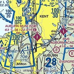
| Sectional chart |
|---|
|
CAUTION: Diagram may not be current

| Airport distance calculator |
|---|
|
|
| Sunrise and sunset |
|---|
|
Times for 23-May-2026
| | Local
(UTC-7) | | Zulu
(UTC) |
|---|
| Morning civil twilight | | 04:47 | | 11:47 |
| Sunrise | | 05:24 | | 12:24 |
| Sunset | | 20:47 | | 03:47 |
| Evening civil twilight | | 21:25 | | 04:25 |
|
| Current date and time |
|---|
| Zulu (UTC) | 23-May-2026 07:30:03 |
|---|
| Local (UTC-7) | 23-May-2026 00:30:03 |
|---|
|
| METAR |
|---|
KSEA
8nm NW | 230653Z 27003KT 10SM SCT250 14/10 A2986 RMK AO2 SLP117 T01440100
|
KRNT
10nm N | 230653Z 01005KT 10SM CLR 18/11 A2985 RMK AO2 SLP112 T01780111
|
KPLU
14nm S | 230715Z AUTO 00000KT 10SM FEW048 13/12 A2988 RMK AO2
|
KBFI
14nm N | 230653Z 00000KT 10SM CLR 17/11 A2985 RMK AO2 SLP108 T01720106
|
KTIW
15nm W | 230653Z AUTO 27006KT 10SM CLR 13/11 A2987 RMK AO2 SLP113 T01330106 402560100
|
KTCM
16nm SW | 230655Z AUTO 29006KT 10SM CLR 15/11 A2986 RMK AO2 SLP114 T01460108 $
|
|
| TAF |
|---|
KSEA
8nm NW | 230520Z 2306/2412 31005KT P6SM FEW100 SCT250 FM231000 22006KT P6SM BKN015 FM232000 23007KT P6SM SCT022 BKN200 FM240100 25008KT P6SM FEW035 SCT200
|
KBFI
14nm N | 230520Z 2306/2406 VRB04KT P6SM FEW250 FM231000 18005KT P6SM BKN015 FM232000 22007KT P6SM SCT025 BKN200
|
KTCM
16nm SW | 230500Z 2305/2411 28006KT 9999 FEW250 QNH2984INS BECMG 2310/2311 VRB05KT 8000 BR OVC005 QNH2991INS BECMG 2316/2317 25010KT 9999 NSW BKN015 OVC020 QNH2997INS BECMG 2317/2318 23012G18KT 9999 FEW020 SCT250 QNH2994INS BECMG 2404/2405 21005KT 9999 FEW250 QNH2996INS TX22/2400Z TN09/2313Z
|
|
| NOTAMs |
|---|
NOTAMs are issued by the DoD/FAA and will open in a separate window not controlled by AirNav.
|
|


