FAA INFORMATION EFFECTIVE 15 MAY 2025
Location
| FAA Identifier: | SEP |
| Lat/Long: | 32-12-55.2000N 098-10-39.6000W
32-12.920000N 098-10.660000W
32.2153333,-98.1776667
(estimated) |
| Elevation: | 1321.4 ft. / 402.8 m (surveyed) |
| Variation: | 07E (1990) |
| From city: | 1 mile E of STEPHENVILLE, TX |
| Time zone: | UTC -5 (UTC -6 during Standard Time) |
| Zip code: | 76401 |
Airport Operations
| Airport use: | Open to the public |
| Activation date: | 05/1945 |
| Control tower: | no |
| ARTCC: | FORT WORTH CENTER |
| FSS: | FORT WORTH FLIGHT SERVICE STATION |
| NOTAMs facility: | SEP (NOTAM-D service available) |
| Attendance: | SAT 0900-1330, ALL MON-FRI 0800-1700 |
| Wind indicator: | lighted |
| Segmented circle: | yes |
| Lights: | SS-SR |
| Beacon: | white-green (lighted land airport)
Operates sunset to sunrise. |
Airport Communications
| CTAF/UNICOM: | 122.8 |
| WX AWOS-3PT: | 118.075 (254-965-8672) |
- APCH/DEP CTL SVC PRVDD BY FORT WORTH ARTCC (ZFW) ON FREQS 127.15/314.0 (DUBLIN/B RCAG).
Nearby radio navigation aids
| VOR radial/distance | | VOR name | | Freq | | Var |
|---|
| MQPr188/32.0 | | MILLSAP VORTAC | | 117.70 | | 09E |
Airport Services
| Fuel available: | 100LL JET-A+
100LL:100LL SELF-SERVE ONLY |
| Parking: | hangars and tiedowns |
| Airframe service: | MAJOR |
| Powerplant service: | MAJOR |
| Bottled oxygen: | NONE |
| Bulk oxygen: | NONE |
Runway Information
Runway 14/32
| Dimensions: | 4209 x 75 ft. / 1283 x 23 m |
| Surface: | asphalt, in good condition |
| Runway edge lights: | medium intensity |
| RUNWAY 14 | | RUNWAY 32 |
| Latitude: | 32-13.217490N | | 32-12.621363N |
| Longitude: | 098-10.869800W | | 098-10.451465W |
| Elevation: | 1321.4 ft. | | 1289.2 ft. |
| Traffic pattern: | left | | left |
| Runway heading: | 142 magnetic, 149 true | | 322 magnetic, 329 true |
| Markings: | nonprecision, in good condition | | nonprecision, in good condition |
| Visual slope indicator: | 2-light PAPI on left
PAPI OTS INDEFLY. | | 2-light PAPI on left
PAPI OTS INDEFLY. |
| Touchdown point: | yes, no lights | | yes, no lights |
| Obstructions: | 40 ft. tree, 915 ft. from runway, 17:1 slope to clear
15 FT. BRUSH, 0-199 FT DSTC, 230 FT L. | | 55 ft. trees, 201 ft. from runway, 220 ft. left of centerline, 1:1 slope to clear
12 FT TREES AND BRUSH 193 FT DSTC 0 FT B. |
Airport Ownership and Management from official FAA records
| Ownership: | Publicly-owned |
| Owner: | CITY OF STEPHENVILLE
298 W. WASHINGTON ST
STEPHENVILLE, TX 76401
Phone 254-918-1294 |
| Manager: | SEAN CLEMMONS
1050 AIRPORT ROAD
STEPHENVILLE, TX 76401
Phone 254-552-1224
AMGR CELL: 254-964-6804 |
Additional Remarks
| - | FOR CD CTC FORT WORTH ARTCC AT 817-858-7584. |
| - | SKYDIVING AND PARACHUTE ACTVTY ON AND INVOF ARPT. |
| - | PRKG AT SELF-SVC FUEL PUMPS FOR RFLG ACFT ONLY. PRKG UNATNDD ACFT AT SELF-SVC FUEL PUMPS IS PROHIBITED. |
| - | RWY 14 PREF WITH CALM WINDS. |
Instrument Procedures
NOTE: All procedures below are presented as PDF files. If you need a reader for these files, you should download the free Adobe Reader.NOT FOR NAVIGATION. Please procure official charts for flight.
FAA instrument procedures published for use from 15 May 2025 at 0901Z to 13 June 2025 at 0900z.
IAPs - Instrument Approach Procedures |
|---|
| RNAV (GPS) RWY 14 | |
download (187KB) |
| RNAV (GPS) RWY 32 | |
download (188KB) |
| NOTE: Special Alternate Minimums apply | |
download (117KB) |
| NOTE: Special Take-Off Minimums/Departure Procedures apply | |
download (217KB) |
Other nearby airports with instrument procedures:
KGDJ - Granbury Regional Airport (23 nm NE)
KMKN - Comanche County-City Airport (28 nm SW)
KMNZ - Hamilton Municipal Airport (33 nm S)
KETN - Eastland Municipal Airport (34 nm W)
KMWL - Mineral Wells Regional Airport (34 nm N)
|
|

Road maps at:
MapQuest
Bing
Google
| Aerial photo |
|---|
WARNING: Photo may not be current or correct
 Photo taken 25-Jul-2008
looking southeast.
Photo taken 25-Jul-2008
looking southeast.
Do you have a better or more recent aerial photo of Stephenville Clark Regional Airport that you would like to share? If so, please send us your photo.
|
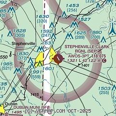
| Sectional chart |
|---|
|
| Airport distance calculator |
|---|
|
|
| Sunrise and sunset |
|---|
|
Times for 28-May-2025
| | Local
(UTC-5) | | Zulu
(UTC) |
|---|
| Morning civil twilight | | 06:01 | | 11:01 |
| Sunrise | | 06:29 | | 11:29 |
| Sunset | | 20:31 | | 01:31 |
| Evening civil twilight | | 20:59 | | 01:59 |
|
| Current date and time |
|---|
| Zulu (UTC) | 29-May-2025 02:08:42 |
|---|
| Local (UTC-5) | 28-May-2025 21:08:42 |
|---|
|
| METAR |
|---|
| KSEP | 290155Z AUTO 09003KT 10SM CLR 20/18 A3002 RMK AO2 T01970176
|
|
| TAF |
|---|
KNFW
50nm NE | 2823/2923 13009KT 9999 VCTS SCT020CB BKN150 QNH2993INS TEMPO 2823/2903 VRB15G25KT 9000 -TSRA BKN020CB FM290300 14009KT 9999 SCT020 SCT150 QNH2993INS BECMG 2907/2909 16009KT 6000 BR BKN020 QNH2993INS TEMPO 2908/2914 BKN009 BECMG 2917/2919 20009KT 9999 VCTS SCT025CB SCT250 QNH2989INS AUTOMATED SENSOR METWATCH 2904 TIL 2911 TX31/2922Z TN21/2910Z FN20070
|
|
| NOTAMs |
|---|
NOTAMs are issued by the DoD/FAA and will open in a separate window not controlled by AirNav.
|
|


