FAA INFORMATION EFFECTIVE 27 NOVEMBER 2025
Location
| FAA Identifier: | SHR |
| Lat/Long: | 44-46-09.1000N 106-58-49.0000W
44-46.151667N 106-58.816667W
44.7691944,-106.9802778
(estimated) |
| Elevation: | 4021.1 ft. / 1225.6 m (surveyed) |
| Variation: | 10E (2020) |
| From city: | 2 miles SW of SHERIDAN, WY |
| Time zone: | UTC -7 (UTC -6 during Daylight Saving Time) |
| Zip code: | 82801 |
Airport Operations
| Airport use: | Open to the public |
| Activation date: | 10/1937 |
| Control tower: | no |
| ARTCC: | SALT LAKE CITY CENTER |
| FSS: | CASPER FLIGHT SERVICE STATION |
| NOTAMs facility: | SHR (NOTAM-D service available) |
| Attendance: | DAYLIGHT HOURS
CONDS NOT MONITORED AT NGT AFT THE LAST ACR ARR TIL 0500L. SEE NOTAMS FOR THE MOST UP-TO-DATE CONDS AND UPDTS. |
| Pattern altitude: | 4821.1 ft. MSL
TPA: 800 FT AGL SNGL ENG, 1500 FT AGL TURBOPROP/JET. |
| Wind indicator: | lighted |
| Segmented circle: | yes |
| Lights: | ACTVT MALSR RWY 33; REIL RWY 06, 24, & 15; PAPI RWY 06, 24, 15 & 33; HIRL RWY 15/33; MIRL RWY 06/24 - CTAF. |
| Beacon: | white-green (lighted land airport)
Operates sunset to sunrise. |
| Fire and rescue: | ARFF index A |
| Airline operations: | PPR UNSKED ACFT OPS WITH MORE THAN 30 PAX SEATS CTC ARFF STN 307-673-1875. |
Airport Communications
| CTAF/UNICOM: | 123.0 |
| WX ASOS: | 135.175 (307-288-0855) |
- APCH/DEP CTL SVC PRVDD BY SALT LAKE ARTCC (ZLC) ON FREQS 127.75/351.9 (SHERIDAN RCAG).
Nearby radio navigation aids
| VOR radial/distance | | VOR name | | Freq | | Var |
|---|
| SHRr132/5.6 | | SHERIDAN VOR/DME | | 113.55 | | 10E |
Airport Services
| Fuel available: | 100 JET-A JET-A1+ |
| Parking: | hangars and tiedowns |
| Airframe service: | MAJOR |
| Powerplant service: | MAJOR |
| Bottled oxygen: | HIGH |
| Bulk oxygen: | HIGH/LOW |
Runway Information
Runway 15/33
| Dimensions: | 8301 x 100 ft. / 2530 x 30 m |
| Surface: | asphalt/porous friction courses, in excellent condition |
| Weight bearing capacity: | | Single wheel: | 60.0 | | Double wheel: | 75.0 |
|
| Runway edge lights: | high intensity |
| RUNWAY 15 | | RUNWAY 33 |
| Latitude: | 44-46.621912N | | 44-45.371225N |
| Longitude: | 106-59.265295W | | 106-58.495338W |
| Elevation: | 4014.2 ft. | | 3975.4 ft. |
| Traffic pattern: | left | | left |
| Runway heading: | 146 magnetic, 156 true | | 326 magnetic, 336 true |
| Declared distances: | TORA:8301 TODA:8301 ASDA:8301 LDA:8301 | | TORA:8301 TODA:8301 ASDA:8301 LDA:8301 |
| Markings: | nonprecision, in good condition | | precision, in good condition |
| Visual slope indicator: | 4-light PAPI on left (3.00 degrees glide path) | | 4-light PAPI on left (3.00 degrees glide path) |
| Approach lights: | | | MALSR: 1,400 foot medium intensity approach lighting system with runway alignment indicator lights |
| Runway end identifier lights: | yes | | |
| Touchdown point: | yes, no lights | | yes, no lights |
| Instrument approach: | | | ILS/DME |
Runway 6/24
| Dimensions: | 5039 x 75 ft. / 1536 x 23 m |
| Surface: | asphalt/grooved, in good condition |
| Weight bearing capacity: | | Single wheel: | 36.0 | | Double wheel: | 50.0 |
|
| Runway edge lights: | medium intensity |
| RUNWAY 6 | | RUNWAY 24 |
| Latitude: | 44-46.252797N | | 44-46.563347N |
| Longitude: | 106-59.252543W | | 106-58.173477W |
| Elevation: | 4021.1 ft. | | 3939.1 ft. |
| Traffic pattern: | left | | left |
| Runway heading: | 058 magnetic, 068 true | | 238 magnetic, 248 true |
| Declared distances: | TORA:5039 TODA:5039 ASDA:5039 LDA:5039 | | TORA:5039 TODA:5039 ASDA:5039 LDA:5039 |
| Markings: | nonprecision, in good condition | | nonprecision, in good condition |
| Visual slope indicator: | 4-light PAPI on left (4.00 degrees glide path) | | 4-light PAPI on left (3.00 degrees glide path) |
| Runway end identifier lights: | yes | | yes |
| Touchdown point: | yes, no lights | | yes, no lights |
| Obstructions: | none | | 40 ft. trees, 750 ft. from runway, 200 ft. right of centerline, 20:1 slope to clear |
Airport Ownership and Management from official FAA records
| Ownership: | Publicly-owned |
| Owner: | SHERIDAN COUNTY
908 W BRUNDAGE LANE
SHERIDAN, WY 82801-5896
Phone 307-674-4222 |
| Manager: | E. ROBERT GILL
908 WEST BRUNDAGE LANE
SHERIDAN, WY 82801-5827
Phone 307-674-4222 |
Additional Remarks
| A39-06/24 | PCR VALUE: 250/F/B/X/T |
| A39-15/33 | PCR VALUE: 260/F/C/X/U |
| - | FW ACFT RSTRD TO RWYS & TWYS ONLY. |
| - | COLD TEMPERATURE AIRPORT. ALTITUDE CORRECTION REQUIRED AT OR BELOW -18C. |
| - | FOR CD IF UNA TO CTC ON FSS FREQ, CTC SALT LAKE ARTCC AT 801-320-2568. |
| - | PILOTS CONDUCTING EFVS OPS; BE AWARE LED ALS IN USE RWY 33. |
Instrument Procedures
NOTE: All procedures below are presented as PDF files. If you need a reader for these files, you should download the free Adobe Reader.NOT FOR NAVIGATION. Please procure official charts for flight.
FAA instrument procedures published for use from 27 November 2025 at 0901Z to 25 December 2025 at 0900Z.
IAPs - Instrument Approach Procedures |
|---|
| ILS OR LOC/DME RWY 33 | |
download (553KB) |
| RNAV (GPS) RWY 15 | |
download (268KB) |
| RNAV (GPS) RWY 33 | |
download (470KB) |
| VOR RWY 15 | |
download (303KB) |
| NOTE: Special Alternate Minimums apply | |
download (131KB) |
| NOTE: Special Take-Off Minimums/Departure Procedures apply | |
download (462KB) |
Other nearby airports with instrument procedures:
KBYG - Johnson County Airport (26 nm SE)
KGEY - South Big Horn County Airport (49 nm W)
U68 - North Big Horn County Airport (63 nm W)
KWRL - Worland Municipal Airport (64 nm SW)
00U - Big Horn County Airport (65 nm NW)
|
|

Road maps at:
MapQuest
Bing
Google
| Aerial photo |
|---|
WARNING: Photo may not be current or correct
 Photo courtesy of AirNav, LLC
Photo taken 11-Sep-2013
looking southeast.
Photo courtesy of AirNav, LLC
Photo taken 11-Sep-2013
looking southeast.
Do you have a better or more recent aerial photo of Sheridan County Airport that you would like to share? If so, please send us your photo.
|
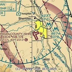
| Sectional chart |
|---|
|
| Airport distance calculator |
|---|
|
|
| Sunrise and sunset |
|---|
|
Times for 18-Dec-2025
| | Local
(UTC-7) | | Zulu
(UTC) |
|---|
| Morning civil twilight | | 07:08 | | 14:08 |
| Sunrise | | 07:42 | | 14:42 |
| Sunset | | 16:28 | | 23:28 |
| Evening civil twilight | | 17:01 | | 00:01 |
|
| Current date and time |
|---|
| Zulu (UTC) | 18-Dec-2025 14:42:49 |
|---|
| Local (UTC-7) | 18-Dec-2025 07:42:49 |
|---|
|
| METAR |
|---|
| KSHR | 181353Z AUTO 35005KT 10SM OVC080 M02/M09 A2998 RMK AO2 SLP178 T10221089
|
|
| TAF |
|---|
| KSHR | 181120Z 1812/1912 33020G30KT P6SM BKN070 OVC090 FM181500 31015KT P6SM BKN250 FM182000 14010KT P6SM BKN250 FM190800 24025G35KT P6SM BKN250 WS020/23050KT
|
|
| NOTAMs |
|---|
NOTAMs are issued by the DoD/FAA and will open in a separate window not controlled by AirNav.
|
|


