FAA INFORMATION EFFECTIVE 14 MAY 2026
Location
| FAA Identifier: | GEY |
| Lat/Long: | 44-31-04.6000N 108-04-58.8000W
44-31.076667N 108-04.980000W
44.5179444,-108.0830000
(estimated) |
| Elevation: | 3941.8 ft. / 1201.5 m (surveyed) |
| Variation: | 10E (2020) |
| From city: | 2 miles NW of GREYBULL, WY |
| Time zone: | UTC -6 (UTC -7 during Standard Time) |
| Zip code: | 82426 |
Airport Operations
| Airport use: | Open to the public |
| Activation date: | 04/1941 |
| Control tower: | no |
| ARTCC: | SALT LAKE CITY CENTER |
| FSS: | CASPER FLIGHT SERVICE STATION |
| NOTAMs facility: | GEY (NOTAM-D service available) |
| Attendance: | UNATNDD |
| Wind indicator: | lighted |
| Segmented circle: | yes |
| Lights: | ACTVT MIRL RWY 16/34; PAPI RWY 16 & 34; REILS RWY 16 & 34 -CTAF. |
| Beacon: | white-green (lighted land airport)
Operates sunset to sunrise. |
Airport Communications
| CTAF: | 122.9 |
| WX ASOS: | 135.325 (307-374-9611) |
- APCH/DEP CTL SVC PRVDD BY SALT LAKE ARTCC (ZLC) ON FREQS 127.75/351.9 ( BILLINGS RCAG).
Nearby radio navigation aids
| VOR radial/distance | | VOR name | | Freq | | Var |
|---|
| RLYr337/33.7 | | WORLAND VOR/DME | | 114.80 | | 13E |
| CODr085/38.2 | | CODY VOR/DME | | 111.80 | | 14E |
Airport Services
| Fuel available: | 100LL JET-A
A:FULL SVC ONLY. FONE AHD 307-680-4897 OR TEXT/CALL AMGR.
100LL:AVLB H24 VIA CREDIT CARD. |
| Parking: | hangars and tiedowns |
| Airframe service: | MAJOR
FOR AIRFRAME AND/OR POWERPLANT RPRS FONE 307-431-1464. |
| Powerplant service: | MAJOR |
| Bottled oxygen: | NONE |
| Bulk oxygen: | NONE |
Runway Information
Runway 16/34
| Dimensions: | 7003 x 150 ft. / 2135 x 46 m |
| Surface: | asphalt, in good condition |
| Weight bearing capacity: | | Single wheel: | 85.0 | | Double wheel: | 150.0 | | Double tandem: | 290.0 |
|
| Runway edge lights: | medium intensity |
| RUNWAY 16 | | RUNWAY 34 |
| Latitude: | 44-31.785938N | | 44-30.653038N |
| Longitude: | 108-04.880015W | | 108-04.585455W |
| Elevation: | 3904.9 ft. | | 3916.1 ft. |
| Traffic pattern: | left | | left |
| Runway heading: | 159 magnetic, 169 true | | 339 magnetic, 349 true |
| Markings: | nonprecision, in good condition | | nonprecision, in good condition |
| Visual slope indicator: | 4-light PAPI on left (3.00 degrees glide path) | | 4-light PAPI on left (3.00 degrees glide path) |
| Runway end identifier lights: | yes | | yes |
| Touchdown point: | yes, no lights | | yes, no lights |
Runway 8/26
| Dimensions: | 3953 x 75 ft. / 1205 x 23 m |
| Surface: | asphalt, in good condition |
| Weight bearing capacity: | |
| RUNWAY 8 | | RUNWAY 26 |
| Latitude: | 44-30.805122N | | 44-30.845847N |
| Longitude: | 108-05.872787W | | 108-04.965595W |
| Elevation: | 3941.8 ft. | | 3919.1 ft. |
| Traffic pattern: | left | | left |
| Runway heading: | 076 magnetic, 086 true | | 256 magnetic, 266 true |
| Markings: | nonprecision, in good condition | | nonprecision, in good condition |
| Touchdown point: | yes, no lights | | yes, no lights |
Airport Ownership and Management from official FAA records
| Ownership: | Publicly-owned |
| Owner: | BIG HORN COUNTY
BOX 29
BASIN, WY 82410
Phone (307) 568-2551 |
| Manager: | PAUL THUR
P.O. BOX 29
BASIN, WY 82410
Phone 307-337-8159 |
Additional Remarks
| - | TERRAIN 1066 FT ABV ARPT ELEV 4-5 MILES NORTH & NE OF ARPT. |
| - | ANTELOPE ON & INVOF RY. |
| - | FOR CD CTC SALT LAKE ARTCC AT 801-320-2568. |
Instrument Procedures
NOTE: All procedures below are presented as PDF files. If you need a reader for these files, you should download the free Adobe Reader.NOT FOR NAVIGATION. Please procure official charts for flight.
FAA instrument procedures published for use from 14 May 2026 at 0901Z to 11 June 2026 at 0900Z.
IAPs - Instrument Approach Procedures |
|---|
| RNAV (GPS) RWY 08 | |
download (268KB) |
| RNAV (GPS) RWY 34 | |
download (259KB) |
| NOTE: Special Alternate Minimums apply | |
download (622KB) |
Departure Procedures |
|---|
| PECKK TWO (RNAV) | |
download (161KB) |
| NOTE: Special Take-Off Minimums/Departure Procedures apply | |
download (553KB) |
Other nearby airports with instrument procedures:
U68 - North Big Horn County Airport (28 nm NW)
KWRL - Worland Municipal Airport (34 nm S)
KPOY - Powell Municipal Airport (37 nm NW)
KCOD - Yellowstone Regional Airport (40 nm W)
KSHR - Sheridan County Airport (49 nm E)
|
|

Road maps at:
MapQuest
Bing
Google
| Aerial photo |
|---|
WARNING: Photo may not be current or correct
 Photo by David Newcomer
Photo taken 30-Sep-2011
looking north.
Photo by David Newcomer
Photo taken 30-Sep-2011
looking north.
Do you have a better or more recent aerial photo of South Big Horn County Airport that you would like to share? If so, please send us your photo.
|
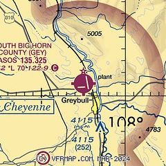
| Sectional chart |
|---|
|
| Airport distance calculator |
|---|
|
|
| Sunrise and sunset |
|---|
|
Times for 28-May-2026
| | Local
(UTC-6) | | Zulu
(UTC) |
|---|
| Morning civil twilight | | 04:58 | | 10:58 |
| Sunrise | | 05:34 | | 11:34 |
| Sunset | | 20:45 | | 02:45 |
| Evening civil twilight | | 21:21 | | 03:21 |
|
| Current date and time |
|---|
| Zulu (UTC) | 28-May-2026 17:02:07 |
|---|
| Local (UTC-6) | 28-May-2026 11:02:07 |
|---|
|
| METAR |
|---|
| KGEY | 281653Z AUTO 15009KT 10SM CLR 27/08 A2987 RMK AO2 SLP069 T02670078
|
|
| TAF |
|---|
KWRL
34nm S | 281120Z 2812/2912 14009KT P6SM SCT100 BKN150 FM281500 18008KT P6SM FEW150 FM282100 20012G18KT P6SM SCT150 FM290300 16007KT P6SM SCT150
|
KCOD
40nm W | 281120Z 2812/2912 21008KT P6SM SCT100 FM281700 06006KT P6SM SCT150 FM282000 05012G18KT P6SM BKN150 PROB30 2820/2824 6SM -TSRA BKN080CB FM290200 21006KT P6SM FEW100
|
|
| NOTAMs |
|---|
NOTAMs are issued by the DoD/FAA and will open in a separate window not controlled by AirNav.
|
|

