FAA INFORMATION EFFECTIVE 09 JULY 2026
Location
| FAA Identifier: | XLL |
| Lat/Long: | 40-34-13.0000N 075-29-17.9000W
40-34.216667N 075-29.298333W
40.5702778,-75.4883056
(estimated) |
| Elevation: | 399 ft. / 121.6 m (surveyed) |
| Variation: | 12W (2005) |
| From city: | 2 miles SW of ALLENTOWN, PA |
| Time zone: | UTC -4 (UTC -5 during Standard Time) |
| Zip code: | 18103 |
Airport Operations
| Airport use: | Open to the public |
| Control tower: | no |
| ARTCC: | NEW YORK CENTER |
| FSS: | WILLIAMSPORT FLIGHT SERVICE STATION |
| NOTAMs facility: | IPT (NOTAM-D service available) |
| Attendance: | 0700-1900 |
| Wind indicator: | lighted |
| Segmented circle: | no |
| Lights: | ACTVT REIL RWY 07/25; MIRL RWY 07/25 & 15/33 - CTAF. |
| Beacon: | white-green (lighted land airport)
Operates sunset to sunrise. |
Airport Communications
| CTAF/UNICOM: | 122.7 |
| WX AWOS-3: | 127.875 (610-231-3111) |
| ALLENTOWN APPROACH: | 119.65 ;3000 FT & BLW 124.45 ;ABV 3000 FT |
| ALLENTOWN DEPARTURE: | 119.65 ;3000 FT & BLW 124.45 ;ABV 3000 FT |
| CLEARANCE DELIVERY: | 118.9 |
| IC: | 119.65 ;3000 FT & BLW 124.45 ;ABV 3000 FT |
| WX ASOS at ABE (5 nm NE): | 126.975 (610-477-0813) |
| WX AWOS-3 at UKT (9 nm SE): | 119.475 (215-538-7610) |
| WX AWOS-3 at CKZ (14 nm SE): | 126.325 (215-257-7291) |
| WX AWOS-3PT at 22N (19 nm NW): | 119.350 (570-386-3423) |
Nearby radio navigation aids
| VOR radial/distance | | VOR name | | Freq | | Var |
|---|
| ETXr103/8.9 | | EAST TEXAS VOR/DME | | 110.20 | | 09W |
| FJCr199/9.5 | | ALLENTOWN VORTAC | | 117.50 | | 10W |
| PTWr018/21.1 | | POTTSTOWN VORTAC | | 116.50 | | 09W |
| ARDr316/32.6 | | YARDLEY VOR/DME | | 108.20 | | 10W |
| BWZr257/33.3 | | BROADWAY VOR/DME | | 114.20 | | 11W |
| SBJr279/34.0 | | SOLBERG VOR/DME | | 112.90 | | 10W |
| STWr239/38.0 | | STILLWATER VOR/DME | | 109.60 | | 11W |
Airport Services
| Fuel available: | 100LL JET-A |
| Parking: | hangars and tiedowns |
| Airframe service: | MAJOR |
| Powerplant service: | MAJOR |
| Bulk oxygen: | NONE |
Runway Information
Runway 7/25
| Dimensions: | 3950 x 75 ft. / 1204 x 23 m |
| Surface: | asphalt/grooved, in good condition |
| Weight bearing capacity: | |
| Runway edge lights: | medium intensity |
| RUNWAY 7 | | RUNWAY 25 |
| Latitude: | 40-33.994163N | | 40-34.336500N |
| Longitude: | 075-29.656837W | | 075-28.931502W |
| Elevation: | 386.4 ft. | | 387.8 ft. |
| Traffic pattern: | left | | left |
| Runway heading: | 070 magnetic, 058 true | | 250 magnetic, 238 true |
| Markings: | nonprecision, in good condition | | basic, in good condition |
| Visual slope indicator: | 4-light PAPI on left (3.00 degrees glide path) | | 4-light PAPI on left (3.50 degrees glide path)
UNUSBL BYD 3 DEG L OF CRS. |
| Runway end identifier lights: | yes | | yes |
| Touchdown point: | yes, no lights | | yes, no lights |
| Obstructions: | 16 ft. brush, 354 ft. from runway, 95 ft. right of centerline, 9:1 slope to clear
4FT SHRUB, 154 FT FM RWY END, 177 FT R. | | 23 ft. pole, lighted, 635 ft. from runway, 112 ft. left of centerline, 19:1 slope to clear |
Runway 15/33
| Dimensions: | 3160 x 75 ft. / 963 x 23 m |
| Surface: | asphalt, in excellent condition |
| Weight bearing capacity: | |
| Runway edge lights: | medium intensity |
| RUNWAY 15 | | RUNWAY 33 |
| Latitude: | 40-34.465998N | | 40-34.097832N |
| Longitude: | 075-29.544667W | | 075-29.062332W |
| Elevation: | 386.1 ft. | | 399.0 ft. |
| Traffic pattern: | left | | left |
| Runway heading: | 147 magnetic, 135 true | | 327 magnetic, 315 true |
| Markings: | basic, in good condition | | basic, in good condition |
| Touchdown point: | yes, no lights | | yes, no lights |
Airport Ownership and Management from official FAA records
| Ownership: | Publicly-owned |
| Owner: | LEHIGH NORTHAM ARPT AUTH
3311 AIRPORT RD
ALLENTOWN, PA 18109
Phone 610-266-6001 |
| Manager: | THOMAS R STOUDT
1730 VULTEE ST
ALLENTOWN, PA 18109
Phone 610-791-5193 |
Additional Remarks
| - | DEER, GROUNDHOGS & BIRDS ON & INVOF ARPT. |
| - | NOISE ABATEMENT PROC IN EFCT, FOR DETAILS CTC AMGR. |
| - | FOR SVC AFT HRS CTC 610-266-6000. |
| - | FOR CD CTC ALLENTOWN APCH AT 800-728-6322. |
Instrument Procedures
NOTE: All procedures below are presented as PDF files. If you need a reader for these files, you should download the free Adobe Reader.NOT FOR NAVIGATION. Please procure official charts for flight.
FAA instrument procedures published for use from 09 July 2026 at 0901Z to 06 August 2026 at 0900Z.
IAPs - Instrument Approach Procedures |
|---|
| RNAV (GPS) RWY 07 | |
download (225KB) |
| NOTE: Special Alternate Minimums apply | |
download (123KB) |
| NOTE: Special Take-Off Minimums/Departure Procedures apply | |
download (149KB) |
Other nearby airports with instrument procedures:
KABE - Lehigh Valley International Airport (5 nm NE)
KUKT - Quakertown Airport (9 nm SE)
KCKZ - Pennridge Airport (14 nm SE)
N43 - Braden Airpark (15 nm NE)
22N - Jake Arner Memorial Airport (19 nm NW)
|
|

Road maps at:
MapQuest
Bing
Google
| Aerial photo |
|---|
WARNING: Photo may not be current or correct
 Photo courtesy of EagleView Reveal Imagery
Taken in 2019
looking north.
Photo courtesy of EagleView Reveal Imagery
Taken in 2019
looking north.
Do you have a better or more recent aerial photo of Allentown Queen City Municipal Airport that you would like to share? If so, please send us your photo.
|
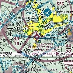
| Sectional chart |
|---|
|
| Airport distance calculator |
|---|
|
|
| Sunrise and sunset |
|---|
|
Times for 16-Jul-2026
| | Local
(UTC-4) | | Zulu
(UTC) |
|---|
| Morning civil twilight | | 05:14 | | 09:14 |
| Sunrise | | 05:46 | | 09:46 |
| Sunset | | 20:30 | | 00:30 |
| Evening civil twilight | | 21:02 | | 01:02 |
|
| Current date and time |
|---|
| Zulu (UTC) | 16-Jul-2026 09:13:04 |
|---|
| Local (UTC-4) | 16-Jul-2026 05:13:04 |
|---|
|
| METAR |
|---|
| KXLL | 160835Z AUTO 00000KT 7SM CLR 22/19 A2996 RMK AO2 TSNO
|
KABE
5nm N | 160851Z 04003KT 6SM BR FEW055 22/20 A2995 RMK AO2 SLP139 T02170200 53003 $
|
KUKT
9nm SE | 160855Z AUTO 00000KT 6SM BR 21/21 A2997 RMK AO2
|
KCKZ
14nm SE | 160855Z AUTO 00000KT 7SM OVC047 20/20 A2997 RMK AO2
|
K22N
19nm NW | 160855Z AUTO 00000KT 1SM BR BKN041 OVC050 19/18 A2997 RMK AO2
|
|
| TAF |
|---|
KABE
5nm N | 160544Z 1606/1706 VRB04KT 6SM FU BKN030 BKN230 FM161000 25007KT 4SM FU SCT022 SCT250 FM161800 26012G22KT 6SM FU FEW040 SCT250 FM162200 31010G18KT 3SM FU SCT050 SCT250 FM170100 33008KT 2SM FU SCT140 SCT250 FM170400 33006KT 3SM FU SCT140 SCT250
|
|
| NOTAMs |
|---|
NOTAMs are issued by the DoD/FAA and will open in a separate window not controlled by AirNav.
|
|


