FAA INFORMATION EFFECTIVE 14 MAY 2026
Location
| FAA Identifier: | ABE |
| Lat/Long: | 40-39-08.5060N 075-26-25.4610W
40-39.141767N 075-26.424350W
40.6523628,-75.4404058
(estimated) |
| Elevation: | 393.7 ft. / 120.0 m (surveyed) |
| Variation: | 12W (2005) |
| From city: | 3 miles NE of ALLENTOWN, PA |
| Time zone: | UTC -4 (UTC -5 during Standard Time) |
| Zip code: | 18103 |
Airport Operations
| Airport use: | Open to the public |
| Activation date: | 06/1938 |
| Control tower: | yes |
| ARTCC: | NEW YORK CENTER |
| FSS: | WILLIAMSPORT FLIGHT SERVICE STATION |
| NOTAMs facility: | ABE (NOTAM-D service available) |
| Attendance: | CONTINUOUS |
| Wind indicator: | lighted |
| Segmented circle: | no |
| Beacon: | white-green (lighted land airport)
Operates sunset to sunrise. |
| Landing fee: | yes |
| Fire and rescue: | ARFF index C |
| International operations: | customs landing rights airport |
Airport Communications
| UNICOM: | 122.95 |
| ATIS: | 126.975 |
| WX ASOS: | 126.975 (610-477-0813) |
| ALLENTOWN GROUND: | 121.9 257.95 |
| ALLENTOWN TOWER: | 120.5 257.95 |
| ALLENTOWN APPROACH: | 119.65 ;3000 FT & BLW 124.45 ;ABV 3000 FT 124.45 ;FROM WEST 351.8 |
| ALLENTOWN DEPARTURE: | 119.65 ;3000 FT & BLW 124.45 ;ABV 3000 FT 124.45 ;FROM WEST 351.8 |
| CLEARANCE DELIVERY: | 124.05 257.95 |
| CLASS C: | 119.65 ;3000 FT & BLW 124.45 ;ABV 3000 FT 351.8 |
| EMERG: | 121.5 243.0 |
| IC: | 119.65 ;3000 FT & BLW 124.45 ;ABV 3000 FT 351.8 |
| WX AWOS-3 at XLL (5 nm SW): | 127.875 (610-231-3111) |
| WX AWOS-3 at UKT (13 nm S): | 119.475 (215-538-7610) |
| WX AWOS-3 at CKZ (17 nm SE): | 126.325 (215-257-7291) |
| WX AWOS-3PT at 22N (17 nm NW): | 119.350 (570-386-3423) |
Nearby radio navigation aids
| VOR radial/distance | | VOR name | | Freq | | Var |
|---|
| FJCr182/4.5 | | ALLENTOWN VORTAC | | 117.50 | | 10W |
| ETXr078/11.9 | | EAST TEXAS VOR/DME | | 110.20 | | 09W |
| PTWr021/26.4 | | POTTSTOWN VORTAC | | 116.50 | | 09W |
| BWZr264/29.5 | | BROADWAY VOR/DME | | 114.20 | | 11W |
| SBJr287/32.1 | | SOLBERG VOR/DME | | 112.90 | | 10W |
| STWr243/33.1 | | STILLWATER VOR/DME | | 109.60 | | 11W |
| ARDr325/34.1 | | YARDLEY VOR/DME | | 108.20 | | 10W |
| LVZr173/38.9 | | WILKES-BARRE VORTAC | | 111.60 | | 10W |
Airport Services
| Fuel available: | 100LL JET-A |
| Parking: | hangars and tiedowns |
| Airframe service: | MAJOR |
| Powerplant service: | MAJOR |
| Bottled oxygen: | NONE |
| Bulk oxygen: | HIGH/LOW |
Runway Information
Runway 6/24
| Dimensions: | 7599 x 150 ft. / 2316 x 46 m |
| Surface: | asphalt/grooved, in good condition |
| Weight bearing capacity: | | Single wheel: | 120.0 | | Double wheel: | 228.0 | | Double tandem: | 368.0 |
|
| Runway edge lights: | high intensity |
| RUNWAY 6 | | RUNWAY 24 |
| Latitude: | 40-38.818893N | | 40-39.601915N |
| Longitude: | 075-27.037952W | | 075-25.756178W |
| Elevation: | 393.7 ft. | | 381.7 ft. |
| Traffic pattern: | left | | left |
| Runway heading: | 063 magnetic, 051 true | | 243 magnetic, 231 true |
| Displaced threshold: | no | | 510 ft. |
| Declared distances: | TORA:7599 TODA:7599 ASDA:7599 LDA:7599 | | TORA:7599 TODA:7599 ASDA:7599 LDA:7089 |
| Markings: | precision, in good condition | | precision, in good condition |
| Visual slope indicator: | 4-light PAPI on left (3.00 degrees glide path) | | 4-light PAPI on right (3.00 degrees glide path) |
| RVR equipment: | touchdown, rollout | | touchdown, rollout |
| Approach lights: | MALSR: 1,400 foot medium intensity approach lighting system with runway alignment indicator lights | | |
| Runway end identifier lights: | | | yes |
| Centerline lights: | yes | | yes |
| Touchdown point: | yes, no lights | | yes, no lights |
| Instrument approach: | ILS | | ILS/DME |
| Obstructions: | 55 ft. trees, 2689 ft. from runway, 720 ft. left of centerline, 45:1 slope to clear | | 24 ft. road, 659 ft. from runway, 549 ft. right of centerline, 19:1 slope to clear
RY 24 HAS APCH RATIO 47:1 TO DSPLCD THLD AND ROADWAY 540 FT RIGHT & 431 FT LEFT & 654 FT FM RY 24 END. |
Runway 13/31
| Dimensions: | 5800 x 150 ft. / 1768 x 46 m |
| Surface: | asphalt/grooved, in good condition |
| Weight bearing capacity: | | Single wheel: | 75.0 | | Double wheel: | 161.0 | | Double tandem: | 290.0 |
|
| Runway edge lights: | high intensity |
| RUNWAY 13 | | RUNWAY 31 |
| Latitude: | 40-39.311835N | | 40-38.791710N |
| Longitude: | 075-26.985958W | | 075-25.934177W |
| Elevation: | 382.9 ft. | | 379.4 ft. |
| Traffic pattern: | left | | left |
| Runway heading: | 135 magnetic, 123 true | | 315 magnetic, 303 true |
| Declared distances: | TORA:5800 TODA:5800 ASDA:5800 LDA:5800 | | TORA:5800 TODA:5800 ASDA:5800 LDA:5800 |
| Markings: | precision, in good condition | | nonprecision, in good condition |
| Visual slope indicator: | | | 4-light PAPI on left (3.00 degrees glide path) |
| Approach lights: | MALSR: 1,400 foot medium intensity approach lighting system with runway alignment indicator lights | | |
| Runway end identifier lights: | | | yes |
| Touchdown point: | yes, no lights | | yes, no lights |
| Instrument approach: | ILS | | |
| Obstructions: | none | | 25 ft. pole, lighted, 272 ft. from runway, 420 ft. right of centerline, 2:1 slope to clear |
Airport Ownership and Management from official FAA records
| Ownership: | Publicly-owned |
| Owner: | LEHIGH NORTHAMPTON A AUTH
3311 AIRPORT RD
ALLENTOWN, PA 18109-3040
Phone 610-266-6000 |
| Manager: | THOMAS R. STOUDT
3311 AIRPORT RD
ALLENTOWN, PA 18109-3040
Phone 610-266-6001 |
Additional Remarks
| A39-06/24 | PCR VALUE: 630/F/C/X/T |
| A39-13/31 | PCR VALUE: 150/F/D/X/T |
| E60-13 | NON-STD ENGINEERED MATERIALS ARRESTING SYSTEM (EMAS) WITH 35 FT SETBACK 251 FT IN LENGTH BY 170 FT IN WIDTH LCTD AT THE DER 13. |
| E60-31 | NON-STD ENGINEERED MATERIALS ARRESTING SYSTEM (EMAS) WITH 35 FT SETBACK 263 FT IN LENGTH BY 170 FT IN WIDTH LCTD AT THE DER 31. |
| - | TPA 1400 FT MSL (1006 FT AGL) RECIPROCATING PROPS; 2000 FT MSL (1606 FT AGL) TURBINE POWERED ACFT. |
| - | TWY B SOUTH OF TWY B3 RSTRD TO ACFT WITH WINGSPAN 118 FT OR LESS. |
| - | TWY E RSTD TO ACFT MAX GWT 12500 LBS. |
| - | TWY J RSTD TO ACFT WITH 118 FT WINGSPAN OR LESS. |
| - | TWY B3 WEST OF RY 13/31 RSTRD TO ACFT WITH WINGSPAN 118 FT OR LESS. |
| - | DURING ATC ZERO EVENTS, ARFF WILL MNT 120.5 FOR EMERG NOTIFICATIONS. |
| - | MIL ACFT PLAN TO PARK & REFUEL ON THE HANGAR-7 APRON. |
| - | BIRDS; GROUNDHOGS & DEER ON & INVOF ARPT. |
| - | FLIGHT NOTIFICATION SERVICE (ADCUS) AVBL - 2 HR PPR. |
| - | TWY C RSTD TO MAXIMUM ACFT WEIGHT 12500 LBS. |
| - | NOISE ABATEMENT PROCEDURES FOR TURBOJET POWERED ACFT IN EFFECT; PREFERENTIAL RY 06/24. |
| - | RY 06 & 24 FLY RY HEADING UNTIL 2000 FT. |
| - | RY 6 13 & 24 DEPS BE ADVISED THAT DEPS ARE OVER A NOISE SENSITIVE AREA. |
| - | RY 31 TURBOJET DEPS TURN RIGHT HEADING 360 DEGS UNTIL 2000 FT MSL. |
Instrument Procedures
NOTE: All procedures below are presented as PDF files. If you need a reader for these files, you should download the free Adobe Reader.NOT FOR NAVIGATION. Please procure official charts for flight.
FAA instrument procedures published for use from 14 May 2026 at 0901Z to 11 June 2026 at 0900Z.
IAPs - Instrument Approach Procedures |
|---|
| ILS OR LOC RWY 06 | |
download (248KB) |
| ILS OR LOC RWY 13 | |
download (280KB) |
| ILS OR LOC/DME RWY 24 | |
download (251KB) |
| ILS RWY 06 (SA CAT I - II) | |
download (255KB) |
| RNAV (GPS) RWY 06 | |
download (245KB) |
| RNAV (GPS) RWY 13 | |
download (226KB) |
| RNAV (GPS) RWY 24 | |
download (244KB) |
| RNAV (GPS) RWY 31 | |
download (226KB) |
| TACAN-C | |
download (185KB) |
| NOTE: Special Alternate Minimums apply | |
download (146KB) |
| NOTE: Special Take-Off Minimums/Departure Procedures apply | |
download (488KB) |
Other nearby airports with instrument procedures:
KXLL - Allentown Queen City Municipal Airport (5 nm SW)
N43 - Braden Airpark (10 nm NE)
KUKT - Quakertown Airport (13 nm S)
KCKZ - Pennridge Airport (17 nm SE)
22N - Jake Arner Memorial Airport (17 nm NW)
N85 - Alexandria Airport (20 nm E)
|
|

Road maps at:
MapQuest
Bing
Google
| Aerial photo |
|---|
WARNING: Photo may not be current or correct
 Photo courtesy of EagleView Reveal Imagery
Taken in 2018
looking north.
Photo courtesy of EagleView Reveal Imagery
Taken in 2018
looking north.
Do you have a better or more recent aerial photo of Lehigh Valley International Airport that you would like to share? If so, please send us your photo.
|
| Sectional chart |
|---|
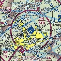
|
CAUTION: Diagram may not be current
 Download PDF
of official airport diagram from the FAA
| Airport distance calculator |
|---|
|
|
| Sunrise and sunset |
|---|
|
Times for 31-May-2026
| | Local
(UTC-4) | | Zulu
(UTC) |
|---|
| Morning civil twilight | | 05:02 | | 09:02 |
| Sunrise | | 05:34 | | 09:34 |
| Sunset | | 20:24 | | 00:24 |
| Evening civil twilight | | 20:57 | | 00:57 |
|
| Current date and time |
|---|
| Zulu (UTC) | 31-May-2026 11:39:04 |
|---|
| Local (UTC-4) | 31-May-2026 07:39:04 |
|---|
|
| METAR |
|---|
| KABE | 311051Z 26003KT 10SM CLR 09/04 A3011 RMK AO2 SLP196 T00940044
|
KXLL
5nm SW | 311115Z AUTO 00000KT 10SM CLR 10/06 A3013 RMK AO2 TSNO
|
KUKT
13nm S | 311115Z AUTO 00000KT 10SM CLR 10/09 A3011 RMK AO2
|
KCKZ
17nm SE | 311115Z AUTO VRB03KT 10SM CLR 10/10 A3011 RMK AO2
|
K22N
17nm NW | 311115Z AUTO 00000KT 10SM CLR 07/05 A3014 RMK AO2
|
|
| TAF |
|---|
| KABE | 310522Z 3106/0106 VRB02KT P6SM SKC FM311400 29006KT P6SM SCT080 FM312300 25003KT P6SM BKN090
|
|
| NOTAMs |
|---|
NOTAMs are issued by the DoD/FAA and will open in a separate window not controlled by AirNav.
|
|


