FAA INFORMATION EFFECTIVE 09 JULY 2026
Location
| FAA Identifier: | ZPH |
| Lat/Long: | 28-13-36.0100N 082-09-20.3230W
28-13.600167N 082-09.338717W
28.2266694,-82.1556453
(estimated) |
| Elevation: | 89.9 ft. / 27.4 m (surveyed) |
| Variation: | 06W (2015) |
| From city: | 1 mile SE of ZEPHYRHILLS, FL |
| Time zone: | UTC -4 (UTC -5 during Standard Time) |
| Zip code: | 33540 |
Airport Operations
| Airport use: | Open to the public |
| Activation date: | 12/1942 |
| Control tower: | no |
| ARTCC: | MIAMI CENTER |
| FSS: | SAINT PETERSBURG FLIGHT SERVICE STATION |
| NOTAMs facility: | PIE (NOTAM-D service available) |
| Attendance: | MON-SAT 0800-1700 |
| Wind indicator: | lighted |
| Segmented circle: | yes |
| Lights: | ACTVT PAPI RWY 01, 05, 19 & 23; REIL RWY 1 & 19 - CTAF. HIRL RWY 1/19; MIRL RWY 5/23 PRESET TO LOW INTST DUSK-2200; INCR INTST & ACTVT AFT 2200 - CTAF. |
| Beacon: | white-green (lighted land airport)
Operates sunset to sunrise. |
Airport Communications
| CTAF/UNICOM: | 123.075 |
| WX AWOS-3PT: | 118.975 (813-780-0031) |
| TAMPA APPROACH: | 119.9 |
| TAMPA DEPARTURE: | 119.9 |
| WX AWOS-3 at PCM (14 nm S): | 120.025 (813-764-8259) |
| WX AWOS-3PT at LAL (16 nm SE): | PHONE 863-834-2030 |
| WX AWOS-3 at VDF (16 nm SW): | 121.125 (813-630-0924) |
Nearby radio navigation aids
| VOR radial/distance | | VOR name | | Freq | | Var |
|---|
| LALr332/16.3 | | LAKELAND VORTAC | | 116.00 | | 01E |
| PIEr061/33.9 | | ST PETERSBURG VORTAC | | 116.40 | | 05W |
Airport Services
| Fuel available: | 100LL JET-A JET-A+
100LL:FUEL AVBL H24 WITH CREDIT CARD; AFT HR FUEL SVC - 813-714-6797. |
| Parking: | hangars and tiedowns |
| Airframe service: | MAJOR |
| Powerplant service: | MAJOR |
| Bottled oxygen: | NONE |
| Bulk oxygen: | NONE |
Runway Information
Runway 1/19
| Dimensions: | 6201 x 100 ft. / 1890 x 30 m |
| Surface: | asphalt, in fair condition |
| Weight bearing capacity: | | PCN 16 /F/B/X/T | | Single wheel: | 47.0 | | Double wheel: | 69.0 |
|
| Runway edge lights: | high intensity |
| RUNWAY 1 | | RUNWAY 19 |
| Latitude: | 28-12.965700N | | 28-13.988935N |
| Longitude: | 082-09.203737W | | 082-09.197463W |
| Elevation: | 78.7 ft. | | 89.3 ft. |
| Traffic pattern: | left | | right |
| Runway heading: | 006 magnetic, 000 true | | 186 magnetic, 180 true |
| Markings: | nonprecision, in good condition | | nonprecision, in fair condition |
| Visual slope indicator: | 4-light PAPI on left (3.00 degrees glide path) | | 4-light PAPI on left (3.00 degrees glide path) |
| Runway end identifier lights: | yes | | yes |
| Touchdown point: | yes, no lights | | yes, no lights |
| Obstructions: | 49 ft. trees, 2385 ft. from runway, 225 ft. left of centerline, 44:1 slope to clear | | 75 ft. trees, 3365 ft. from runway, 42:1 slope to clear |
Runway 5/23
| Dimensions: | 5001 x 100 ft. / 1524 x 30 m |
| Surface: | asphalt/grooved, in good condition |
| Weight bearing capacity: | | PCN 16 /F/A/X/T | | Single wheel: | 53.0 | | Double wheel: | 75.0 |
|
| Runway edge lights: | medium intensity |
| RUNWAY 5 | | RUNWAY 23 |
| Latitude: | 28-13.449172N | | 28-14.055748N |
| Longitude: | 082-09.825903W | | 082-09.194022W |
| Elevation: | 85.4 ft. | | 87.9 ft. |
| Traffic pattern: | left | | right |
| Runway heading: | 049 magnetic, 043 true | | 229 magnetic, 223 true |
| Markings: | nonprecision, in fair condition | | nonprecision, in fair condition |
| Visual slope indicator: | 4-light PAPI on left (3.63 degrees glide path) | | 4-light PAPI on left (3.61 degrees glide path) |
| Touchdown point: | yes, no lights | | yes, no lights |
| Obstructions: | 59 ft. trees, 2230 ft. from runway, 235 ft. right of centerline, 34:1 slope to clear | | 42 ft. trees, 1470 ft. from runway, 155 ft. right of centerline, 30:1 slope to clear |
Airport Ownership and Management from official FAA records
| Ownership: | Publicly-owned |
| Owner: | CITY OF ZEPHYRHILLS
39450 SOUTH AVENUE
ZEPHYRHILLS, FL 33542
Phone 813-780-0030 |
| Manager: | NATHAN COLEMAN
ZEPHYRHILLS MUNICIPAL AIRPORT, 39450 SOUTH AVENUE
ZEPHYRHILLS, FL 33542
Phone 813-780-0030 |
Additional Remarks
| - | 24 FT PLINE CROSSES APCH 800-1300 FT FROM RWY 23 END; MKD WITH RED FLAGS. |
| - | PATTERN ALTITUDE TWIN ENGINE 1500 FT AGL. |
| - | 24 HR ADVN NOTICE OR IMT REPORTING UPON LDG FOR ACFT EQUIPPED WITH WEATHER MODIFICATION OR GEOENGINEERING EQUIP CTC ARPT 813-456-7890. |
| - | GLIDER OPS 6000 FT & BLW SR-SS. |
| - | SKY-DIVING ACFT DESCENDING FROM 13500 FT & ENTERING OPPOSITE TFC PAT FOR RWY 1/19 E OF ARPT. |
| - | PAEW ADJ TO RWYS & TWYS. |
| - | EXERCISE CAUTION; EXTENSIVE ACFT OPS ALL CATS & TYPES USING RWY 1/19; PARL TWY NOT AVBL. |
| - | NOISE SENSITIVE AREA NE & WEST OF ARPT; MNTN PAT ALTS & AVOID PWR CHG OVR RESIDENTAL AREAS. |
| - | FOR CD CTC TAMPA APCH AT 813-878-2528. |
Instrument Procedures
NOTE: All procedures below are presented as PDF files. If you need a reader for these files, you should download the free Adobe Reader.NOT FOR NAVIGATION. Please procure official charts for flight.
FAA instrument procedures published for use from 09 July 2026 at 0901Z to 06 August 2026 at 0900Z.
IAPs - Instrument Approach Procedures |
|---|
| RNAV (GPS) RWY 01 | |
download (212KB) |
| RNAV (GPS) RWY 05 | |
download (213KB) |
| RNAV (GPS) RWY 19 | |
download (226KB) |
| RNAV (GPS) RWY 23 | |
download (242KB) |
| NOTE: Special Alternate Minimums apply | |
download (148KB) |
| NOTE: Special Take-Off Minimums/Departure Procedures apply | |
download (406KB) |
Other nearby airports with instrument procedures:
KPCM - Plant City Airport (14 nm S)
KLAL - Lakeland Linder International Airport (16 nm SE)
KVDF - Tampa Executive Airport (16 nm SW)
KBKV - Brooksville-Tampa Bay Regional Airport (22 nm NW)
KGIF - Winter Haven Regional Airport (23 nm SE)
|
|

Road maps at:
MapQuest
Bing
Google
| Aerial photo |
|---|
WARNING: Photo may not be current or correct
 Photo by David TK Hayes
Photo taken 27-Aug-2010
looking east.
Photo by David TK Hayes
Photo taken 27-Aug-2010
looking east.
Do you have a better or more recent aerial photo of Zephyrhills Municipal Airport that you would like to share? If so, please send us your photo.
|
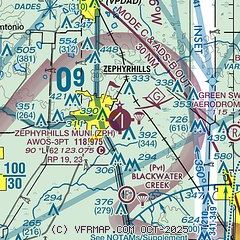
| Sectional chart |
|---|
|
| Airport distance calculator |
|---|
|
|
| Sunrise and sunset |
|---|
|
Times for 27-Jul-2026
| | Local
(UTC-4) | | Zulu
(UTC) |
|---|
| Morning civil twilight | | 06:23 | | 10:23 |
| Sunrise | | 06:49 | | 10:49 |
| Sunset | | 20:21 | | 00:21 |
| Evening civil twilight | | 20:47 | | 00:47 |
|
| Current date and time |
|---|
| Zulu (UTC) | 27-Jul-2026 04:44:16 |
|---|
| Local (UTC-4) | 27-Jul-2026 00:44:16 |
|---|
|
| METAR |
|---|
| KZPH | 270435Z AUTO 23004KT 10SM CLR 25/23 A2999 RMK A02 T02510233
|
KPCM
14nm S | 270435Z AUTO 00000KT 10SM CLR 25/25 A2998 RMK AO2 T02520247 $
|
KVDF
16nm SW | 270435Z AUTO 00000KT 9SM CLR 25/24 A2997 RMK AO2 T02470245 $
|
KLAL
17nm SE | 270435Z AUTO 00000KT 10SM CLR 25/24 A2998 RMK AO2 T02510241 $
|
|
| TAF |
|---|
KLAL
17nm SE | 261742Z 2618/2718 27009KT P6SM VCTS SCT030CB BKN050 FM262200 VRB03KT P6SM SCT030 BKN250 FM271200 27002KT P6SM VCSH SCT030 BKN250 FM271500 29007KT P6SM VCTS SCT030CB BKN250 TEMPO 2717/2718 VRB25G35KT 2SM +TSRA BKN020CB
|
|
| NOTAMs |
|---|
NOTAMs are issued by the DoD/FAA and will open in a separate window not controlled by AirNav.
|
|


