FAA INFORMATION EFFECTIVE 20 MARCH 2025
Location
| FAA Identifier: | LNK |
| Lat/Long: | 40-51-03.2090N 096-45-32.8360W
40-51.053483N 096-45.547267W
40.8508914,-96.7591211
(estimated) |
| Elevation: | 1218.7 ft. / 371.5 m (surveyed) |
| Variation: | 03E (2015) |
| From city: | 4 miles NW of LINCOLN, NE |
| Time zone: | UTC -5 (UTC -6 during Standard Time) |
| Zip code: | 68524 |
Airport Operations
| Airport use: | Open to the public |
| Activation date: | 04/1940 |
| Control tower: | yes |
| ARTCC: | MINNEAPOLIS CENTER |
| FSS: | COLUMBUS FLIGHT SERVICE STATION |
| NOTAMs facility: | LNK (NOTAM-D service available) |
| Attendance: | CONTINUOUS |
| Pattern altitude: | HVY MIL JET TPA 1781 FT AGL |
| Wind indicator: | lighted |
| Segmented circle: | no |
| Lights: | WHEN ATCT CLSD, MALSR RWYS 18 & 36 OPR CONSLY ON LOW INTST; ODALS RWY 35 OPR CONSLY ON MED INTST; REIL RWY 14 OPR CONSLY ON LOW INTST; REIL RWY 17 OPR CONSLY ON MED INTST; MIRL RWY 14/32 AND RWY 17/35 OPR CONSLY ON LOW INTST; HIRL RWY 18/36 OPR CONSLY ON MED INTST. VASI RWY 32; PAPI RWYS 14, 17, 18, 35, & 36 OPR CONSLY. |
| Beacon: | white-green (lighted land airport)
Operates sunset to sunrise. |
| Fire and rescue: | ARFF index B |
| Airline operations: | INDEX C LVL ARFF EQPT PRVDD; FOR ARFF SVC - CTAF. |
Airport Communications
| CTAF: | 118.5 |
| UNICOM: | 122.95 |
| ATIS: | 118.05 290.9 |
| WX ASOS: | PHONE 402-417-0560 |
| LINCOLN GROUND: | 121.9 275.8 [0600 - 2200] |
| LINCOLN TOWER: | 118.5 253.5 125.7 [0600 - 2200] |
| OMAHA APPROACH: | 124.0 |
| OMAHA DEPARTURE: | 124.0 |
| CLEARANCE DELIVERY: | 120.7 225.4 |
| ANG OPS: | 234.65 |
| ARNG OPS: | 138.75 255.8 30.1FM |
| CLASS C: | 124.0 |
| IC: | 118.5 253.5 124.0 |
Nearby radio navigation aids
| VOR radial/distance | | VOR name | | Freq | | Var |
|---|
| LNKr181/4.4 | | LINCOLN VORTAC | | 116.10 | | 09E |
| BIEr353/(33.0) | | BEATRICE VOR | | 110.60 | | 07E |
| NDB name | | Hdg/Dist | | Freq | | Var | | ID |
|---|
| WAHOO | | 191/24.4 | | 400 | | 06E | | AHQ | .- .... --.- |
| PLATTSMOUTH | | 257/38.8 | | 329 | | 05E | | PMV | .--. -- ...- |
| YORK | | 088/39.0 | | 257 | | 06E | | JYR | .--- -.-- .-. |
| BEKLOF | | 064/40.0 | | 392 | | 03E | | FMZ | ..-. -- --.. |
Airport Services
| Fuel available: | 100LL JET-A |
| Parking: | hangars and tiedowns |
| Airframe service: | MAJOR |
| Powerplant service: | MAJOR |
| Bottled oxygen: | HIGH/LOW |
| Bulk oxygen: | HIGH |
Runway Information
Runway 18/36
| Dimensions: | 12901 x 200 ft. / 3932 x 61 m |
| Surface: | asphalt/concrete/grooved, in fair condition |
| Weight bearing capacity: | | Single wheel: | 100.0 | | Double wheel: | 200.0 | | Double tandem: | 400.0 |
|
| Runway edge lights: | high intensity |
| RUNWAY 18 | | RUNWAY 36 |
| Latitude: | 40-51.779497N | | 40-49.655050N |
| Longitude: | 096-45.700538W | | 096-45.714298W |
| Elevation: | 1195.2 ft. | | 1174.7 ft. |
| Traffic pattern: | right | | left |
| Runway heading: | 177 magnetic, 180 true | | 357 magnetic, 360 true |
| Declared distances: | TORA:12901 TODA:12901 ASDA:12901 LDA:12901 | | TORA:12901 TODA:12901 ASDA:12901 LDA:12901 |
| Markings: | precision, in good condition | | precision, in good condition |
| Visual slope indicator: | 4-light PAPI on left (3.00 degrees glide path) | | 4-light PAPI on left (3.00 degrees glide path) |
| RVR equipment: | touchdown, rollout | | touchdown, rollout |
| Approach lights: | MALSR: 1,400 foot medium intensity approach lighting system with runway alignment indicator lights | | MALSR: 1,400 foot medium intensity approach lighting system with runway alignment indicator lights |
| Touchdown point: | yes, no lights | | yes, no lights |
| Instrument approach: | ILS | | ILS |
Runway 14/32
| Dimensions: | 8649 x 150 ft. / 2636 x 46 m |
| Surface: | asphalt/grooved, in fair condition |
| Weight bearing capacity: | | Single wheel: | 80.0 | | Double wheel: | 170.0 | | Double tandem: | 280.0 |
|
| Runway edge lights: | medium intensity |
| RUNWAY 14 | | RUNWAY 32 |
| Latitude: | 40-52.038300N | | 40-50.871080N |
| Longitude: | 096-46.180543W | | 096-45.105523W |
| Elevation: | 1198.9 ft. | | 1177.7 ft. |
| Traffic pattern: | left | | left |
| Runway heading: | 142 magnetic, 145 true | | 322 magnetic, 325 true |
| Displaced threshold: | 363 ft. | | 470 ft. |
| Declared distances: | TORA:8649 TODA:8649 ASDA:8649 LDA:8286 | | TORA:8649 TODA:8649 ASDA:8286 LDA:7816 |
| Markings: | nonprecision, in good condition | | nonprecision, in good condition |
| Visual slope indicator: | 4-light PAPI on left (3.00 degrees glide path) | | 4-box VASI on left (3.00 degrees glide path)
VASI UNUSBL BYD 8 DEGS LEFT OF CNTRLN AND 6 DEGS RIGHT OF CNTRLN. |
| Runway end identifier lights: | yes | | |
| Touchdown point: | yes, no lights | | yes, no lights |
| Obstructions: | none | | 59 ft. pole, 2475 ft. from runway, 375 ft. right of centerline, 38:1 slope to clear
APCH RATIO FM DTHR 49:1. |
Runway 17/35
| Dimensions: | 5801 x 100 ft. / 1768 x 30 m |
| Surface: | asphalt/grooved, in good condition |
| Weight bearing capacity: | | Single wheel: | 45.0 | | Double wheel: | 59.0 |
|
| Runway edge lights: | medium intensity |
| RUNWAY 17 | | RUNWAY 35 |
| Latitude: | 40-51.680548N | | 40-50.725402N |
| Longitude: | 096-45.045262W | | 096-45.051448W |
| Elevation: | 1218.7 ft. | | 1173.0 ft. |
| Traffic pattern: | left | | right |
| Runway heading: | 177 magnetic, 180 true | | 357 magnetic, 360 true |
| Declared distances: | TORA:5800 TODA:5800 ASDA:5400 LDA:5400 | | TORA:5800 TODA:5800 ASDA:5800 LDA:5800 |
| Markings: | nonprecision, in good condition | | nonprecision, in good condition |
| Visual slope indicator: | 4-light PAPI on left (3.00 degrees glide path) | | 4-light PAPI on left (3.00 degrees glide path) |
| Approach lights: | | | ODALS: omnidirectional approach lighting system |
| Runway end identifier lights: | yes | | no |
| Touchdown point: | yes, no lights | | yes, no lights |
Airport Ownership and Management from official FAA records
| Ownership: | Publicly-owned |
| Owner: | LINCOLN ARPT AUTH
BOX 80407
LINCOLN, NE 68501
Phone 402-458-2400 |
| Manager: | MR. DAVID HARING
LINCOLN AIRPORT AUTHORITY, P.O. BOX 80407
LINCOLN, NE 68501
Phone 402-458-2400
EXECUTIVE DIRECTOR. |
Additional Remarks
| A39-18/36 | PCR VALUE: 672/R/B/W/U |
| A39-14/32 | PCR VALUE: 450/F/B/X/U |
| A39-17/35 | PCR VALUE: 140/R/C/W/T |
| A30A-32 | APCH HOLDLINE ON SOUTH TWY A. |
| A30A-18 | CALM WIND RWY. |
| - | BIRDS INVOF ARPT. |
| - | ANG: CTC AM OPS 234.65 20 MIN PRIOR TO LDG. |
| - | ANG: PROVISIONAL PORT OF ENTRY: US CUSTOMS AVBL ONLY WITH 24 HR NOTICE AND ONLY FOR DOD AIRCREW AND DOD DUTY PAX ON TRAVEL ORDERS. CTC COMD POST. SPACE-A US CUSTOMS ENTRY TO THE US AT THIS ARPT LIMITED TO ACTIVE DUTY MILITARY PERSONNEL ON LEAVE (NO DEPENDENTS). |
| - | ARNG: OPR 1300-2100Z++ TUE-FRI, LTD TRAN MAINT. |
| - | ARNG: RAMP IS OFFL BUS/PPR TO PRK ARNG RAMP CTC FLT OPS DSN 279-1844, C402-309-1844. |
| - | ENSURE CORRECT RWY LINEUP. RWY 17/35 IS THE SHRTR, PARL RWY ON E SIDE OF ARPT. |
| - | ANG: AM OPS DSN 279-1293; C402-309-1293. |
| - | PPR 24 HRS FOR ACFT PARKING ON THE WEST RAMP - CTC ARPT 402-458-2480. |
| - | ANG: CTC AM OPS 234.65 FOR BWC. |
| - | FOR CD WHEN ATCT IS CLSD CTC OMAHA APCH AT 402-682-4395. |
| - | AF: USAF TMPRY OPS ON WEST RAMP FR APRX SPRING 2021 TO FALL 2022. |
| - | PPR TO PARK ON ANG RAMP. |
Instrument Procedures
NOTE: All procedures below are presented as PDF files. If you need a reader for these files, you should download the free Adobe Reader.NOT FOR NAVIGATION. Please procure official charts for flight.
FAA instrument procedures published for use from 20 March 2025 at 0901Z to 17 April 2025 at 0900z.
IAPs - Instrument Approach Procedures |
|---|
| HI-ILS Z OR LOC Z RWY 18 | |
download (142KB) |
| HI-ILS Z OR LOC Z RWY 36 | |
download (142KB) |
| ILS Y OR LOC Y RWY 18 | |
download (346KB) |
| ILS Y OR LOC Y RWY 36 | |
download (252KB) |
| RNAV (GPS) RWY 14 | |
download (264KB) |
| RNAV (GPS) RWY 17 | |
download (253KB) |
| RNAV (GPS) RWY 18 | |
download (291KB) |
| RNAV (GPS) RWY 32 | |
download (281KB) |
| RNAV (GPS) RWY 35 | |
download (245KB) |
| RNAV (GPS) RWY 36 | |
download (289KB) |
| HI-VOR/DME OR TACAN RWY 36 | |
download (136KB) |
| VOR RWY 17 | |
download (239KB) |
| VOR Y RWY 18 | |
download (239KB) |
| HI-VOR Z OR TACAN RWY 18 | |
download (148KB) |
| NOTE: Special Alternate Minimums apply | |
download (147KB) |
| NOTE: Special Take-Off Minimums/Departure Procedures apply | |
download (147KB) |
Other nearby airports with instrument procedures:
KCEK - Crete Municipal Airport (16 nm SW)
KSWT - Seward Municipal Airport (16 nm W)
KAHQ - Wahoo Municipal Airport (25 nm N)
93Y - David City Municipal Airport (28 nm NW)
KBIE - Beatrice Municipal Airport (33 nm S)
|
|

Road maps at:
MapQuest
Bing
Google
| Aerial photo |
|---|
WARNING: Photo may not be current or correct
 Photo by William H. Maxey
Photo taken 09-May-2006
Photo by William H. Maxey
Photo taken 09-May-2006
Do you have a better or more recent aerial photo of Lincoln Airport that you would like to share? If so, please send us your photo.
|
| Sectional chart |
|---|
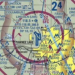
|
CAUTION: Diagram may not be current
 Download PDF
of official airport diagram from the FAA
| Airport distance calculator |
|---|
|
|
| Sunrise and sunset |
|---|
|
Times for 13-Apr-2025
| | Local
(UTC-5) | | Zulu
(UTC) |
|---|
| Morning civil twilight | | 06:24 | | 11:24 |
| Sunrise | | 06:52 | | 11:52 |
| Sunset | | 20:03 | | 01:03 |
| Evening civil twilight | | 20:31 | | 01:31 |
|
| Current date and time |
|---|
| Zulu (UTC) | 14-Apr-2025 04:33:44 |
|---|
| Local (UTC-5) | 13-Apr-2025 23:33:44 |
|---|
|
| METAR |
|---|
| KLNK | 140354Z AUTO 32008KT 10SM CLR 16/03 A2994 RMK AO2 SLP130 T01610033
|
|
| TAF |
|---|
| KLNK | 140130Z 1402/1424 33018G25KT P6SM BKN250 FM140600 33020G30KT P6SM BKN180
|
|
| NOTAMs |
|---|
NOTAMs are issued by the DoD/FAA and will open in a separate window not controlled by AirNav.
|
|


