FAA INFORMATION EFFECTIVE 17 APRIL 2025
Location
| FAA Identifier: | LRG |
| Lat/Long: | 45-21-42.6600N 068-32-04.0480W
45-21.711000N 068-32.067467W
45.3618500,-68.5344578
(estimated) |
| Elevation: | 207.9 ft. / 63.4 m (surveyed) |
| Variation: | 19W (1995) |
| From city: | 2 miles SW of LINCOLN, ME |
| Time zone: | UTC -4 (UTC -5 during Standard Time) |
| Zip code: | 04457 |
Airport Operations
| Airport use: | Open to the public |
| Activation date: | 12/1972 |
| Control tower: | no |
| ARTCC: | BOSTON CENTER |
| FSS: | BANGOR FLIGHT SERVICE STATION |
| NOTAMs facility: | BGR (NOTAM-D service available) |
| Attendance: | UNATNDD |
| Wind indicator: | yes |
| Segmented circle: | yes |
| Lights: | ACTVT REIL RWY 16 & 34; MIRL RWY 16/34 - CTAF. |
| Beacon: | white-green (lighted land airport)
Operates sunset to sunrise. |
Airport Communications
| CTAF/UNICOM: | 122.8 |
| WX ASOS at MLT (18 nm N): | 135.225 (207-723-8396) |
- APCH/DEP SVC PRVDD BY BOSTON ARTCC ON FREQ 124.25/290.50 (BANGOR RCAG).
Nearby radio navigation aids
| VOR radial/distance | | VOR name | | Freq | | Var |
|---|
| MLTr203/13.5 | | MILLINOCKET VOR/DME | | 117.90 | | 20W |
| BGRr044/34.4 | | BANGOR VORTAC | | 114.80 | | 19W |
| NDB name | | Hdg/Dist | | Freq | | Var | | ID |
|---|
| MILNOT | | 195/17.2 | | 344 | | 17W | | LNT | .-.. -. - |
Airport Services
| Fuel available: | 100LL
100LL:24 HR FUEL WITH MAJOR CREDIT CARD. |
| Parking: | hangars and tiedowns |
| Airframe service: | NONE |
| Powerplant service: | NONE |
| Bottled oxygen: | NONE |
| Bulk oxygen: | NONE |
Runway Information
Runway 16/34
| Dimensions: | 2805 x 60 ft. / 855 x 18 m |
| Surface: | asphalt, in good condition |
| Weight bearing capacity: | |
| Runway edge lights: | medium intensity |
| RUNWAY 16 | | RUNWAY 34 |
| Latitude: | 45-21.905128N | | 45-21.516878N |
| Longitude: | 068-32.244495W | | 068-31.890447W |
| Elevation: | 196.5 ft. | | 206.4 ft. |
| Traffic pattern: | left | | left |
| Runway heading: | 166 magnetic, 147 true | | 346 magnetic, 327 true |
| Markings: | nonprecision, in good condition | | nonprecision, in good condition |
| Runway end identifier lights: | yes | | yes |
| Touchdown point: | yes, no lights | | yes, no lights |
Runway 6W/24W
| Dimensions: | 2400 x 100 ft. / 732 x 30 m |
| Surface: | water |
| RUNWAY 6W | | RUNWAY 24W |
| Traffic pattern: | left | | left |
| Touchdown point: | yes, no lights | | yes, no lights |
| Obstructions: | 64 ft. pline, marked, 960 ft. from runway, 15:1 slope to clear | | 94 ft. trees, 1410 ft. from runway, 15:1 slope to clear |
Airport Ownership and Management from official FAA records
| Ownership: | Publicly-owned |
| Owner: | TOWN OF LINCOLN
29 MAIN ST
LINCOLN, ME 04457
Phone 207-794-3372 |
| Manager: | STEW JACOBS
29 MAIN ST
LINCOLN, ME 04457
Phone 207-403-0524
ALTN NR 207-290-7174, DENNIS BULLEN. |
Additional Remarks
| - | 40 FT BRIDGE AT S END WATER LDG AREA. |
| - | WILDLIFE ON & INVOF ARPT. |
| - | RWY 6W-24W FOLLOW BUOYS UNDER BRIDGE DURING LOW WATER IN SUMMER. |
| - | FOR CD CTC BOSTON ARTCC AT 603-879-6859. |
Instrument Procedures
NOTE: All procedures below are presented as PDF files. If you need a reader for these files, you should download the free Adobe Reader.NOT FOR NAVIGATION. Please procure official charts for flight.
FAA instrument procedures published for use from 17 April 2025 at 0901Z to 15 May 2025 at 0900z.
IAPs - Instrument Approach Procedures |
|---|
| RNAV (GPS) RWY 16 | |
download (214KB) |
| RNAV (GPS) RWY 34 | |
download (210KB) |
| NOTE: Special Take-Off Minimums/Departure Procedures apply | |
download (521KB) |
Other nearby airports with instrument procedures:
KMLT - Millinocket Municipal Airport (18 nm N)
KOLD - Dewitt Field/Old Town Municipal Airport (25 nm S)
KBGR - Bangor International Airport (36 nm S)
1B0 - Dexter Regional Airport (37 nm SW)
KPNN - Princeton Municipal Airport (42 nm E)
|
|

Road maps at:
MapQuest
Bing
Google
| Aerial photo |
|---|
WARNING: Photo may not be current or correct
 Photo by Pete Chaisson- Portland Flight Services
Photo taken 27-May-2015
looking east.
Photo by Pete Chaisson- Portland Flight Services
Photo taken 27-May-2015
looking east.
Do you have a better or more recent aerial photo of Lincoln Regional Airport that you would like to share? If so, please send us your photo.
|
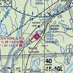
| Sectional chart |
|---|
|
| Airport distance calculator |
|---|
|
|
| Sunrise and sunset |
|---|
|
Times for 22-Apr-2025
| | Local
(UTC-4) | | Zulu
(UTC) |
|---|
| Morning civil twilight | | 05:06 | | 09:06 |
| Sunrise | | 05:38 | | 09:38 |
| Sunset | | 19:28 | | 23:28 |
| Evening civil twilight | | 19:59 | | 23:59 |
|
| Current date and time |
|---|
| Zulu (UTC) | 22-Apr-2025 08:26:01 |
|---|
| Local (UTC-4) | 22-Apr-2025 04:26:01 |
|---|
|
| METAR |
|---|
KMLT
19nm N | 220753Z AUTO 13004KT 10SM -RA BKN006 OVC046 03/03 A3005 RMK AO2 SLP184 P0001 T00330033
|
KBGR
36nm S | 220753Z 13006KT 10SM OVC048 05/03 A3005 RMK AO2 RAE14 SLP175 P0001 T00500028
|
|
| TAF |
|---|
KBGR
36nm S | 220524Z 2206/2306 15005KT P6SM -SHRA OVC050 FM220800 15006KT P6SM -SHRA OVC025 FM221100 15007KT 5SM -SHRA OVC007 FM222000 13007KT P6SM OVC005 FM230200 VRB03KT P6SM BKN016
|
|
| NOTAMs |
|---|
NOTAMs are issued by the DoD/FAA and will open in a separate window not controlled by AirNav.
|
|


