FAA INFORMATION EFFECTIVE 09 JULY 2026
Location
| FAA Identifier: | MAF |
| Lat/Long: | 31-56-33.1000N 102-12-06.9000W
31-56.551667N 102-12.115000W
31.9425278,-102.2019167
(estimated) |
| Elevation: | 2872.1 ft. / 875.4 m (surveyed) |
| Variation: | 09E (1985) |
| From city: | 8 miles SW of MIDLAND, TX |
| Time zone: | UTC -5 (UTC -6 during Standard Time) |
| Zip code: | 79706 |
Airport Operations
| Airport use: | Open to the public |
| Activation date: | 09/1937 |
| Control tower: | yes |
| ARTCC: | FORT WORTH CENTER |
| FSS: | SAN ANGELO FLIGHT SERVICE STATION |
| NOTAMs facility: | MAF (NOTAM-D service available) |
| Attendance: | CONTINUOUS |
| Wind indicator: | lighted |
| Segmented circle: | yes |
| Lights: | ATC CTL. WHEN ATCT CLSD HIRL RWYS 10/28 & 16R/34L PRESET ON LOW INTST. WHEN ATCT CLSD ACTVT MALSR RWY 10; MALS RWY 28; MIRL RWYS 04/22 & 16L/34R - CTAF. |
| Beacon: | white-green (lighted land airport)
Operates sunset to sunrise. |
| Landing fee: | yes |
| Fire and rescue: | ARFF index C |
| Airline operations: | FOR ARFF SVC BTN 0000-0600 DLY CTC FSS AT 800-992-7433. |
| International operations: | US CUSTOMS USER FEE ARPT. |
Airport Communications
| CTAF: | 118.7 |
| UNICOM: | 122.95 |
| ATIS: | 126.8 235.975 |
| WX ASOS: | PHONE 432-201-2813 |
| MIDLAND GROUND: | 121.9 348.6 [0600-0000] |
| MIDLAND TOWER: | 118.7 273.45 [0600-0000] |
| MIDLAND APPROACH: | 121.1 ;137-240 124.6 ;241-136 256.875 ;137-240 290.4 ;241-136 [MIDLAND 0600-0000 SAN ANGELO 0600-2100] |
| MIDLAND DEPARTURE: | 121.1 ;137-240 124.6 ;241-136 256.875 ;137-240 290.4 ;241-136 [MIDLAND 0600-0000 SAN ANGELO 0600-2100] |
| CLEARANCE DELIVERY: | 118.05 317.65 |
| CLASS C: | 121.1 ;137-240 124.6 ;241-136 256.875 ;137-240 290.4 ;241-136 |
| EMERG: | 121.5 243.0 |
| IC: | 124.6 ;241-136 290.4 ;241-136 |
| WX AWOS-3 at MDD (8 nm NE): | 118.125 (432-687-4605) |
| WX ASOS at ODO (10 nm W): | 119.275 (432-363-9719) |
- APCH/DEP SVC PRVDD BY FORT WORTH ARTCC (ZFW) ON FREQS 133.1/298.95 (MIDLAND RCAG) WHEN MIDLAND APCH CLSD.
Nearby radio navigation aids
| VOR radial/distance | | VOR name | | Freq | | Var |
|---|
| MAFr177/4.1 | | MIDLAND VORTAC | | 112.60 | | 11E |
| NDB name | | Hdg/Dist | | Freq | | Var | | ID |
|---|
| FARLY | | 105/6.8 | | 326 | | 09E | | MA | -- .- |
Airport Services
| Fuel available: | 100LL JET-A JET-A1 |
| Parking: | hangars and tiedowns |
| Airframe service: | MAJOR |
| Powerplant service: | MAJOR |
| Bottled oxygen: | LOW |
| Bulk oxygen: | LOW |
Runway Information
Runway 16R/34L
| Dimensions: | 9501 x 150 ft. / 2896 x 46 m |
| Surface: | asphalt/grooved, in good condition |
| Weight bearing capacity: | | Single wheel: | 160.0 | | Double wheel: | 200.0 | | Double tandem: | 350.0 | | Dual double tandem: | 700.0 |
|
| Runway edge lights: | high intensity |
| Operational restrictions: | 180 DEG TURN PROHIBITED TO ACFT 60000 LBS OR ABV. |
| RUNWAY 16R | | RUNWAY 34L |
| Latitude: | 31-57.564327N | | 31-56.003405N |
| Longitude: | 102-12.330978W | | 102-12.172175W |
| Elevation: | 2872.1 ft. | | 2851.0 ft. |
| Traffic pattern: | left | | left |
| Runway heading: | 166 magnetic, 175 true | | 346 magnetic, 355 true |
| Declared distances: | TORA:9501 TODA:9501 ASDA:9501 LDA:9501 | | TORA:9501 TODA:9501 ASDA:9501 LDA:9501 |
| Markings: | precision, in good condition | | precision, in good condition |
| Visual slope indicator: | 4-light PAPI on left (3.00 degrees glide path) | | 4-light PAPI on left (3.00 degrees glide path) |
| Runway end identifier lights: | | | yes |
| Touchdown point: | yes, no lights | | yes, no lights |
| Obstructions: | none | | 28 ft. pole, 1550 ft. from runway, 300 ft. left of centerline, 48:1 slope to clear |
Runway 10/28
| Dimensions: | 8302 x 150 ft. / 2530 x 46 m
EAST 692 FT CLSD TO ACFT OVER 60000 LBS. |
| Surface: | asphalt/grooved, in good condition |
| Weight bearing capacity: | | Single wheel: | 160.0 | | Double wheel: | 200.0 | | Double tandem: | 350.0 | | Dual double tandem: | 700.0 |
|
| Runway edge lights: | high intensity |
| Operational restrictions: | 180 DEG TURN PROHIBITED TO ACFT 60000 LBS OR ABV. |
| RUNWAY 10 | | RUNWAY 28 |
| Latitude: | 31-56.858637N | | 31-56.310785N |
| Longitude: | 102-12.980958W | | 102-11.509598W |
| Elevation: | 2869.3 ft. | | 2854.0 ft. |
| Traffic pattern: | left | | left |
| Runway heading: | 105 magnetic, 114 true | | 285 magnetic, 294 true |
| Displaced threshold: | no | | 691 ft. |
| Declared distances: | TORA:8302 TODA:8302 ASDA:8177 LDA:8177 | | TORA:8302 TODA:8302 ASDA:8302 LDA:7610 |
| Markings: | precision, in good condition | | precision, in good condition |
| Visual slope indicator: | 4-light PAPI on left (3.00 degrees glide path) | | 4-light PAPI on right (3.00 degrees glide path) |
| RVR equipment: | touchdown | | rollout |
| Approach lights: | MALSR: 1,400 foot medium intensity approach lighting system with runway alignment indicator lights | | MALS: 1,400 foot medium intensity approach lighting system |
| Touchdown point: | yes, no lights | | yes, no lights |
| Instrument approach: | ILS/DME | | |
Runway 4/22
| Dimensions: | 4605 x 75 ft. / 1404 x 23 m |
| Surface: | asphalt, in good condition |
| Weight bearing capacity: | | PCN 19 /F/B/X/T | | Single wheel: | 30.0 | | Double wheel: | 60.0 |
|
| Runway edge lights: | medium intensity |
| Operational restrictions: | RWY 04/22 NOT AVBL FOR PART 121/PART 380 OPS WITH SKED PAX CARRYING OPS MORE THAN 9 PAX SEATS AND NON-SKED PAX CARRYING OPS MORE THAN 30 PAX SEATS. |
| RUNWAY 4 | | RUNWAY 22 |
| Latitude: | 31-55.902165N | | 31-56.352097N |
| Longitude: | 102-12.225055W | | 102-11.507663W |
| Elevation: | 2851.3 ft. | | 2854.9 ft. |
| Traffic pattern: | left | | left |
| Runway heading: | 045 magnetic, 054 true | | 225 magnetic, 234 true |
| Declared distances: | TORA:4605 TODA:4605 ASDA:4605 LDA:4605 | | TORA:4605 TODA:4605 ASDA:4605 LDA:4605 |
| Markings: | nonprecision, in good condition | | nonprecision, in good condition |
| Touchdown point: | yes, no lights | | yes, no lights |
| Obstructions: | 57 ft. pole, 2688 ft. from runway, 390 ft. right of centerline, 43:1 slope to clear | | 23 ft. road, 1333 ft. from runway, 9 ft. left of centerline, 49:1 slope to clear |
Runway 16L/34R
| Dimensions: | 4247 x 100 ft. / 1294 x 30 m |
| Surface: | asphalt, in good condition |
| Weight bearing capacity: | | PCN 19 /F/B/X/T | | Single wheel: | 30.0 | | Double wheel: | 60.0 |
|
| Runway edge lights: | medium intensity |
| Operational restrictions: | RWY 16L/34R NOT AVBL FOR PART 121/PART 380 OPS WITH SKED PAX CARRYING OPS MORE THAN 9 PAX SEATS AND NON-SKED PAX CARRYING OPS MORE THAN 30 PAX SEATS. |
| RUNWAY 16L | | RUNWAY 34R |
| Latitude: | 31-56.774202N | | 31-56.074777N |
| Longitude: | 102-11.847683W | | 102-11.807027W |
| Elevation: | 2864.6 ft. | | 2847.9 ft. |
| Traffic pattern: | left | | left |
| Runway heading: | 168 magnetic, 177 true | | 348 magnetic, 357 true |
| Declared distances: | TORA:4247 TODA:4247 ASDA:4247 LDA:4247 | | TORA:4247 TODA:4247 ASDA:4247 LDA:4247 |
| Markings: | basic, in good condition | | basic, in good condition |
| Touchdown point: | yes, no lights | | yes, no lights |
| Obstructions: | 7 ft. fence, 375 ft. from runway, 100 ft. both sides of centerline, 25:1 slope to clear | | 13 ft. road, 390 ft. from runway, 250 ft. right of centerline, 14:1 slope to clear |
Airport Ownership and Management from official FAA records
| Ownership: | Publicly-owned |
| Owner: | CITY OF MIDLAND
PO BOX 1152
MIDLAND, TX 79702
Phone 432-685-7100 |
| Manager: | JUSTINE RUFF
PO BOX 60305
MIDLAND, TX 79711
Phone 432-560-2200 |
Additional Remarks
| A39-16R/34L | PCR VALUE: 730/F/B/X/T |
| A39-10/28 | PCR VALUE: 660/F/B/X/T |
| - | OPRS ON NON PAVED SFC ARE PROHIBITED WO 24 HR PPR. |
| - | RWYS 04/22 & 16L/34R CLSD TO ACFT OVER 60000 LBS. |
| - | TWYS B & F NORTH RWY 10/28 CLSD TO ACFT OVER 60000 LBS. |
| - | BIRD ACTIVITY ON & INVOF ARPT. |
| - | NMRS OIL RIGS INVOF ARPT AT OR BLW 200 FT AGL. |
| - | ALL RUNUP PADS ARE LTD USAGE TO ACFT 60000 LBS OR BLW. |
| - | FOR CD IF UNA TO CTC ON FSS FREQ, CTC FORT WORTH ARTCC AT 817-858-7584. |
Instrument Procedures
NOTE: All procedures below are presented as PDF files. If you need a reader for these files, you should download the free Adobe Reader.NOT FOR NAVIGATION. Please procure official charts for flight.
FAA instrument procedures published for use from 09 July 2026 at 0901Z to 06 August 2026 at 0900Z.
IAPs - Instrument Approach Procedures |
|---|
| ILS OR LOC RWY 10 | |
download (315KB) |
| RNAV (GPS) RWY 04 | |
download (213KB) |
| RNAV (GPS) RWY 10 | |
download (219KB) |
| RNAV (GPS) RWY 16R | |
download (212KB) |
| RNAV (GPS) RWY 22 | |
download (206KB) |
| RNAV (GPS) RWY 28 | |
download (212KB) |
| RNAV (GPS) RWY 34L | |
download (212KB) |
| HI-VOR OR TACAN RWY 16R | |
download (126KB) |
| HI-VOR OR TACAN RWY 34L | |
download (113KB) |
| VOR OR TACAN RWY 16R | |
download (238KB) |
| VOR OR TACAN RWY 34L | |
download (231KB) |
| NOTE: Special Alternate Minimums apply | |
download (61KB) |
| NOTE: Special Take-Off Minimums/Departure Procedures apply | |
download (171KB) |
Other nearby airports with instrument procedures:
KMDD - Midland Airpark (8 nm NE)
KODO - Odessa Airport-Schlemeyer Field (10 nm W)
E11 - Andrews County Airport (29 nm NW)
KBPG - Big Spring/Mc Mahon-Wrinkle Airport (38 nm NE)
E01 - Roy Hurd Memorial Airport (42 nm SW)
|
|

Road maps at:
MapQuest
Bing
Google
| Aerial photo |
|---|
WARNING: Photo may not be current or correct
 Taken in May 2008
looking north.
Taken in May 2008
looking north.
Do you have a better or more recent aerial photo of Midland International Air and Space Port Airport that you would like to share? If so, please send us your photo.
|
| Sectional chart |
|---|
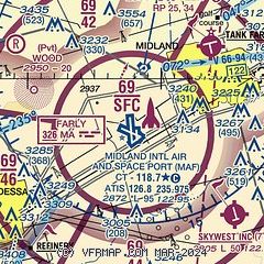
|
 Download PDF
of official airport diagram from the FAA
| Airport distance calculator |
|---|
|
|
| Sunrise and sunset |
|---|
|
Times for 18-Jul-2026
| | Local
(UTC-5) | | Zulu
(UTC) |
|---|
| Morning civil twilight | | 06:29 | | 11:29 |
| Sunrise | | 06:56 | | 11:56 |
| Sunset | | 20:54 | | 01:54 |
| Evening civil twilight | | 21:21 | | 02:21 |
|
| Current date and time |
|---|
| Zulu (UTC) | 18-Jul-2026 07:32:33 |
|---|
| Local (UTC-5) | 18-Jul-2026 02:32:33 |
|---|
|
| METAR |
|---|
| KMAF | 180653Z AUTO 16007KT 10SM CLR 23/19 A3010 RMK AO2 SLP149 T02280189
|
KODO
10nm W | 180653Z AUTO 17010KT 10SM CLR 23/19 A3011 RMK AO2 SLP152 T02280189 $
|
|
| TAF |
|---|
| KMAF | 180521Z 1806/1906 15013KT P6SM FEW040 BKN250 FM181900 16015G20KT P6SM SCT045 BKN250 PROB30 1820/1902 VRB15G25KT 6SM -TSRA BKN040CB FM190200 14008KT P6SM FEW040 BKN200
|
|
| NOTAMs |
|---|
NOTAMs are issued by the DoD/FAA and will open in a separate window not controlled by AirNav.
|
|


