FAA INFORMATION EFFECTIVE 15 MAY 2025
Location
| FAA Identifier: | MEM |
| Lat/Long: | 35-02-32.6810N 089-58-36.0450W
35-02.544683N 089-58.600750W
35.0424114,-89.9766792
(estimated) |
| Elevation: | 340.9 ft. / 103.9 m (surveyed) |
| Variation: | 01W (2020) |
| From city: | 3 miles S of MEMPHIS, TN |
| Time zone: | UTC -5 (UTC -6 during Standard Time) |
| Zip code: | 38116 |
Airport Operations
| Airport use: | Open to the public |
| Activation date: | 08/1937 |
| Control tower: | yes |
| ARTCC: | MEMPHIS CENTER |
| FSS: | JACKSON FLIGHT SERVICE STATION |
| NOTAMs facility: | MEM (NOTAM-D service available) |
| Attendance: | CONTINUOUS |
| Wind indicator: | lighted |
| Segmented circle: | no |
| Lights: | SS-SR |
| Beacon: | white-green (lighted land airport)
Operates sunset to sunrise. |
| Fire and rescue: | ARFF index C |
| Airline operations: | INDEX D ARFF EQUIP H24. |
| International operations: | customs landing rights airport |
Airport Communications
| UNICOM: | 122.95 |
| WX ASOS: | 127.75 (901-842-8483) |
| MEMPHIS GROUND: | 121.0 ;RWY 09/27 121.65 ;RWY 18R/36L 121.9 ;RWY 18L/36R, 18C/36C 379.2 |
| MEMPHIS TOWER: | 118.3 ;RWY 09/27 119.7 ;RWY 18L/36R, 18C/36C 128.425 ;RWY 18R/36L 257.8 |
| MEMPHIS APPROACH: | 119.1 ;176-355 125.8 ;356-175 |
| MEMPHIS DEPARTURE: | 124.15 ;356-175 124.65 ;176-355 |
| CLEARANCE DELIVERY: | 125.2 125.2 |
| PRE-TAXI CLEARANCE: | 125.2 125.2 |
| ANG COMD POST: | 138.1 353.45 |
| AUTMN DP: | 124.65 |
| AZONE DP: | 124.15 |
| BBKNG DP: | 124.15 |
| BINKY DP: | 124.65 |
| CHLDR DP: | 124.65 |
| CLASS B: | 119.1 ;176-355 125.8 ;356-175 |
| CRSON DP: | 124.15 |
| D-ATIS: | 127.75 |
| DUCKZ DP: | 124.65 |
| EMERG: | 121.5 243.0 |
| FINAL: | 120.925 126.05 ;RWY 09/27 126.7 |
| GENEH DP: | 124.15 |
| GMBUD DP: | 124.15 |
| GOETZ DP: | 124.15 |
| GRRIZ DP: | 124.65 |
| HOTRD DP: | 124.65 |
| IC: | 119.1 ;176-355 125.8 ;356-175 |
| JTEEE DP: | 124.65 |
| NIKEI DP: | 124.65 |
| OLEMS DP: | 124.65 |
| PIEPE DP: | 124.65 |
| SELPH DP: | 124.15 |
| ZUMIT DP: | 124.65 |
| WX AWOS-3 at OLV (10 nm E): | 119.925 (662-893-5906) |
| WX AWOS-3PT at M01 (10 nm N): | 118.35 (901-354-9296) |
| WX ASOS at AWM (14 nm NW): | 118.175 (870-733-9987) |
| WX AWOS-3PT at 2M8 (14 nm N): | 119.575 (901-873-0903) |
| WX AWOS-3 at NQA (20 nm N): | 118.925 (901-873-3630) |
- ASDE-X IN USE. OPERATE TRANSPONDERS WITH ALTITUDE REPORTING MODE AND ADS-B (IF EQUIPPED) ENABLED ON ALL AIRPORT SURFACES.
Nearby radio navigation aids
| VOR radial/distance | | VOR name | | Freq | | Var |
|---|
| MEMr010/1.7 | | MEMPHIS VORTAC | | 117.50 | | 01E |
| HLIr302/28.7 | | HOLLY SPRINGS VORTAC | | 112.40 | | 03E |
| GQEr123/30.6 | | GILMORE VOR/DME | | 113.00 | | 04E |
Airport Services
| Fuel available: | 100LL JET-A JET-A+ JET-A++ |
| Parking: | hangars and tiedowns |
| Airframe service: | MAJOR |
| Powerplant service: | MAJOR |
| Bulk oxygen: | HIGH/LOW |
Runway Information
Runway 18C/36C
| Dimensions: | 11120 x 150 ft. / 3389 x 46 m |
| Surface: | concrete/grooved, in good condition |
| Weight bearing capacity: | | Single wheel: | 120.0 | | Double wheel: | 250.0 | | Double tandem: | 550.0, SINGLE BELLY TWIN TANDEM LNDG GEAR - 621. | | Dual double tandem: | 1120.0 |
|
| Runway edge lights: | high intensity |
| RUNWAY 18C | | RUNWAY 36C |
| Latitude: | 35-03.275685N | | 35-01.443005N |
| Longitude: | 089-58.570260W | | 089-58.531628W |
| Elevation: | 270.6 ft. | | 340.9 ft. |
| Traffic pattern: | left | | right |
| Runway heading: | 180 magnetic, 179 true | | 000 magnetic, 359 true |
| Declared distances: | TORA:11120 TODA:11120 ASDA:11120 LDA:11120 | | TORA:11120 TODA:11120 ASDA:10715 LDA:10715 |
| Markings: | precision, in good condition | | precision, in good condition |
| Visual slope indicator: | | | 4-light PAPI on left (3.00 degrees glide path) |
| RVR equipment: | touchdown, midfield, rollout | | touchdown, midfield, rollout |
| Approach lights: | MALSR: 1,400 foot medium intensity approach lighting system with runway alignment indicator lights | | ALSF2: standard 2,400 foot high intensity approach lighting system with centerline sequenced flashers (category II or III) |
| Runway end identifier lights: | no | | no |
| Centerline lights: | yes | | yes |
| Touchdown point: | yes, lighted | | yes, lighted |
| Instrument approach: | ILS | | ILS/DME |
| Obstructions: | 64 ft. pole, 2593 ft. from runway, 804 ft. right of centerline, 37:1 slope to clear | | 36 ft. tree, 1849 ft. from runway, 745 ft. left of centerline, 45:1 slope to clear |
Runway 18R/36L
| Dimensions: | 9320 x 150 ft. / 2841 x 46 m |
| Surface: | concrete/grooved, in good condition |
| Weight bearing capacity: | | Single wheel: | 120.0 | | Double wheel: | 250.0 | | Double tandem: | 550.0, SINGLE BELLY TWIN TANDEM LNDG GEAR - 621. | | Dual double tandem: | 1120.0 |
|
| Runway edge lights: | high intensity |
| Operational restrictions: | A-GEAR: ENGRD MTRL EMAS 316 FT LEN 178 FT WID DEP END RWY 18R. |
| RUNWAY 18R | | RUNWAY 36L |
| Latitude: | 35-02.969148N | | 35-01.433087N |
| Longitude: | 089-59.246522W | | 089-59.213535W |
| Elevation: | 288.4 ft. | | 320.8 ft. |
| Traffic pattern: | right | | left |
| Runway heading: | 180 magnetic, 179 true | | 000 magnetic, 359 true |
| Declared distances: | TORA:9320 TODA:9320 ASDA:9320 LDA:9320 | | TORA:9320 TODA:9320 ASDA:9320 LDA:9320 |
| Markings: | precision, in good condition | | precision, in good condition |
| Visual slope indicator: | | | 4-light PAPI on left (3.00 degrees glide path) |
| RVR equipment: | touchdown, midfield, rollout | | touchdown, midfield, rollout |
| Approach lights: | MALSR: 1,400 foot medium intensity approach lighting system with runway alignment indicator lights | | ALSF2: standard 2,400 foot high intensity approach lighting system with centerline sequenced flashers (category II or III) |
| Runway end identifier lights: | no | | no |
| Centerline lights: | yes | | yes |
| Touchdown point: | yes, lighted | | yes, lighted |
| Instrument approach: | ILS | | ILS/DME |
| Obstructions: | none | | 30 ft. tree, 1284 ft. from runway, 662 ft. left of centerline, 36:1 slope to clear |
Runway 18L/36R
| Dimensions: | 9000 x 150 ft. / 2743 x 46 m |
| Surface: | concrete/grooved, in good condition |
| Weight bearing capacity: | | Single wheel: | 120.0 | | Double wheel: | 250.0 | | Double tandem: | 550.0, SINGLE BELLY TWIN TANDEM LNDG GEAR - 621. | | Dual double tandem: | 1120.0 |
|
| Runway edge lights: | high intensity |
| RUNWAY 18L | | RUNWAY 36R |
| Latitude: | 35-02.929003N | | 35-01.445627N |
| Longitude: | 089-58.377048W | | 089-58.345907W |
| Elevation: | 277.6 ft. | | 334.3 ft. |
| Traffic pattern: | left | | left |
| Runway heading: | 180 magnetic, 179 true | | 000 magnetic, 359 true |
| Declared distances: | TORA:9000 TODA:9000 ASDA:9000 LDA:9000 | | TORA:9000 TODA:9000 ASDA:9000 LDA:9000 |
| Markings: | precision, in good condition | | precision, in good condition |
| Visual slope indicator: | 4-light PAPI on left (3.00 degrees glide path) | | 4-light PAPI on right (3.00 degrees glide path) |
| RVR equipment: | touchdown, midfield, rollout | | touchdown, midfield, rollout |
| Approach lights: | MALSR: 1,400 foot medium intensity approach lighting system with runway alignment indicator lights | | ALSF2: standard 2,400 foot high intensity approach lighting system with centerline sequenced flashers (category II or III)
ALSF2 UNMNTD. |
| Runway end identifier lights: | no | | no |
| Centerline lights: | yes | | yes |
| Touchdown point: | yes, lighted | | yes, lighted |
| Instrument approach: | ILS/DME | | ILS/DME |
| Obstructions: | none | | 101 ft. trees, 2780 ft. from runway, 739 ft. right of centerline, 25:1 slope to clear |
Runway 9/27
| Dimensions: | 8946 x 150 ft. / 2727 x 46 m |
| Surface: | concrete/grooved, in good condition |
| Weight bearing capacity: | | Single wheel: | 120.0 | | Double wheel: | 250.0 | | Double tandem: | 550.0 | | Dual double tandem: | 1120.0 |
|
| Runway edge lights: | high intensity |
| RUNWAY 9 | | RUNWAY 27 |
| Latitude: | 35-03.517433N | | 35-03.466880N |
| Longitude: | 089-59.144227W | | 089-57.351360W |
| Elevation: | 253.2 ft. | | 292.0 ft. |
| Traffic pattern: | left | | left |
| Runway heading: | 093 magnetic, 092 true | | 273 magnetic, 272 true |
| Declared distances: | TORA:8946 TODA:8946 ASDA:8946 LDA:8946 | | TORA:8946 TODA:8946 ASDA:8946 LDA:8946 |
| Markings: | precision, in good condition | | precision, in good condition |
| Visual slope indicator: | | | 4-light PAPI on left (3.00 degrees glide path) |
| RVR equipment: | touchdown, rollout | | touchdown, rollout |
| Approach lights: | MALSR: 1,400 foot medium intensity approach lighting system with runway alignment indicator lights | | MALSR: 1,400 foot medium intensity approach lighting system with runway alignment indicator lights |
| Runway end identifier lights: | no | | no |
| Centerline lights: | yes | | yes |
| Touchdown point: | yes, no lights | | yes, no lights |
| Instrument approach: | ILS | | ILS |
| Obstructions: | 27 ft. pole, 1243 ft. from runway, 607 ft. left of centerline, 38:1 slope to clear | | 50 ft. pole, 1707 ft. from runway, 662 ft. right of centerline, 30:1 slope to clear |
Airport Ownership and Management from official FAA records
| Ownership: | Publicly-owned |
| Owner: | MEMPHIS SHELBY CNTY ARPT AUTH
2491 WINCHESTER RD.
MEMPHIS, TN 38116-3856
Phone 901-922-8000 |
| Manager: | TERRY BLUE
2491 WINCHESTER RD., SUITE 113
MEMPHIS, TN 38116-3856
Phone 901-922-8000 |
Additional Remarks
| A39-18R/36L | PCR VALUE: 1253/R/C/W/T |
| A39-09/27 | PCR VALUE: 1253/R/C/W/T |
| A39-18L/36R | PCR VALUE: 1207/R/C/W/T |
| A39-18C/36C | PCR VALUE: 1253/R/C/W/T |
| - | TWY N NORTH OF TWY V, TWY C NORTH OF TWY V, TWY S NORTH OF TWY V AND TWY V WEST OF TWY N DESIGNATED AS NON-MOVEMENT AREAS. |
| - | LRG & HVY EBND ACFT ON TWY V FOR RWY 27 HOLD SHORT AT MNM THRUST AREA SIGN. |
| - | PPR FOR TAXI CLNC ON TWY N NORTH OF TWY V, TWY S NORTH TWY V & TWY C NORTH OF TWY V - FEDEX RAMP ATCT 131.5. |
| - | TWY V BTN SPOT 7W & RWY 27 RSTR TO ACFT WITH WINGSPAN OF 171 FT 6 IN OR LESS. |
| - | TWY V BTN TWY S & Y RSTR TO ACFT WITH TAIL HEIGHT 65 FT 10 IN OR LESS. |
| - | ANG-PPR DSN 726-7131/7505, C901-291-7131/7505. MIL RAMP OPS 1230-0430Z++ MON-FRI; CLSD ALTN MON & HOL. MIL RAMP CLSD OUTSIDE OF PUB HR WITHOUT OG/CC APVL DSN 726-7557, C901-291-7557. TSNT ACFT MAINT NOT AVBL. REFUEL SVC FOR OTR THAN C17 ACFT RQR QUALIFIED CREW CHIEF OR CREWMEMBERS. NON-C17 ACFT SUPPORT PRVDD BY CONTRACT FBO ON FLD. SECURITY AVBL 24 HRS, DSN 726-7101, C901-291-7101. COMD POST DSN 726-7148/7311/7312, C901-291-7148/7311/7312. OPR 1230-0430Z++ MON-FRI, CLSD ALTN MON AND HOL DUE TO ALTN WORK SCHED. AFLD MGR DOES NOT ISSUE OR STORE COMSEC FOR TRAN CRES. TMPRY STOR OF CLASSIFIED MATERIALS UP TO TOP SECRET AT COMD POST. |
| - | CTC RAMP CONTROL 121.8 FOR ENTRY ON ANG RAMP. ANG FREQS 138.95 353.45. AFT HR CTC COMMAND POST - DSN 726-7148; C901-291-7311/7312 OR SECURITY FORCES - DSN 726-7101; C901-291-7101/7133. |
| - | HOLD SHORT INSTRN READ BACK RQR. |
| - | BASH PHASE II APR-MAY & AUG-OCT; CURRENT BIRD WATCH COND NOT ON ATIS. |
| - | ANG RAMP OFFL BUS ONLY; PPR - V966-8131. TSNT ACFT RQR FOLLOW ME ASSIST ENTERING ANG RAMP. |
| - | PPR FOR TAXI CLNC FM N & S CARGO RAMP PRKG - 121.9. |
| - | COMMUNICATIONS-ANG COMD POST: RADIO CALL GRACELAND OPS. |
| - | NOISE ABATEMENT PROC IN EFCT. SUCCESSIVE AND/OR SIMUL DEP APVD ON RWY 36L-18R & RWY 36C-18C OR RWY 36L-18R & RWY 36R-18L WITH COURSE DVRGNC NO LATER THAN 2.27 NM FROM RWY END. |
| - | ANG: PPR 24 HR PN RQR; OFFL BUS ONLY. |
| - | AIRCRAFT WITH WINGSPANS GREATER THAN 118 FEET RESTRICTED FROM TAXIING ON TWY J NORTH OF TWY U. |
| - | ANG-ATIS INFO RPRTS BIRD ACT H24. |
| - | HELI OPS TO/FM TRML BLDG NA. |
| - | MIL: MIL RAMP OPS AT REDUCED ARFF, DOWNGRADED TO YELLOW. |
| - | TWY N BTN TWY M & TWY M7 CLSD TO WINGSPAN MORE THAN 171.5 FT EXC TAX SPEED LESS THAN 15 MPH. |
| - | MEM AD AP ALL SAFETY AREA NOT STD GRADING. |
| - | PILOTS CONDUCTING EFVS OPS; BE AWARE LED ALS IN USE RWY 18L. |
| - | BIRDS INVOF ARPT. |
Instrument Procedures
NOTE: All procedures below are presented as PDF files. If you need a reader for these files, you should download the free Adobe Reader.NOT FOR NAVIGATION. Please procure official charts for flight.
FAA instrument procedures published for use from 15 May 2025 at 0901Z to 13 June 2025 at 0900z.
STARs - Standard Terminal Arrivals |
|---|
| BLUZZ FIVE (RNAV) | |
download (313KB) |
| BRBBQ THREE (RNAV) | |
download (323KB) |
| CONDR FOUR (RNAV) | |
download (157KB) |
| DAWGG TWO | |
2 pages:
[1] [2] (352KB) |
| HOBRK FOUR (RNAV) | |
download (324KB) |
| HYTHR THREE (RNAV) | |
download (155KB) |
| MARVELL SIX | |
2 pages:
[1] [2] (405KB) |
| MONAA FOUR (RNAV) | |
download (184KB) |
| VANZE THREE (RNAV) | |
download (318KB) |
| WLDER ONE | |
2 pages:
[1] [2] (336KB) |
IAPs - Instrument Approach Procedures |
|---|
| ILS OR LOC RWY 09 **CHANGED** | |
download (320KB) |
| ILS OR LOC RWY 18C **CHANGED** | |
download (338KB) |
| ILS OR LOC RWY 18L **CHANGED** | |
download (386KB) |
| ILS OR LOC RWY 18R **CHANGED** | |
download (394KB) |
| ILS OR LOC RWY 27 **CHANGED** | |
download (386KB) |
| ILS OR LOC RWY 36C **CHANGED** | |
download (349KB) |
| ILS OR LOC RWY 36L **CHANGED** | |
download (377KB) |
| ILS OR LOC RWY 36R **CHANGED** | |
download (358KB) |
| ILS RWY 36C (CAT II - III) **CHANGED** | |
download (317KB) |
| ILS RWY 36L (CAT II - III) **CHANGED** | |
download (353KB) |
| ILS RWY 36R (CAT II - III) **CHANGED** | |
download (326KB) |
| RNAV (RNP) X RWY 18L **CHANGED** | |
download (298KB) |
| RNAV (RNP) X RWY 18R **CHANGED** | |
download (299KB) |
| RNAV (RNP) Y RWY 18C **CHANGED** | |
download (309KB) |
| RNAV (RNP) Y RWY 18L **CHANGED** | |
download (305KB) |
| RNAV (RNP) Y RWY 18R **CHANGED** | |
download (304KB) |
| RNAV (GPS) RWY 09 **CHANGED** | |
download (337KB) |
| RNAV (GPS) RWY 27 **CHANGED** | |
download (317KB) |
| RNAV (GPS) RWY 36C **CHANGED** | |
download (355KB) |
| RNAV (GPS) RWY 36L **CHANGED** | |
download (378KB) |
| RNAV (GPS) RWY 36R **CHANGED** | |
download (375KB) |
| RNAV (GPS) Z RWY 18C **CHANGED** | |
download (353KB) |
| RNAV (GPS) Z RWY 18L **CHANGED** | |
download (342KB) |
| RNAV (GPS) Z RWY 18R **CHANGED** | |
download (316KB) |
| NOTE: Special Alternate Minimums apply | |
download (51KB) |
Departure Procedures |
|---|
| AUTMN SIX (RNAV) | |
2 pages:
[1] [2] (391KB) |
| AZONE SEVEN (RNAV) | |
2 pages:
[1] [2] (414KB) |
| BBKNG SEVEN (RNAV) | |
2 pages:
[1] [2] (411KB) |
| BINKY SIX (RNAV) | |
2 pages:
[1] [2] (393KB) |
| CHLDR FIVE (RNAV) | |
2 pages:
[1] [2] (405KB) |
| CRSON SEVEN (RNAV) | |
2 pages:
[1] [2] (435KB) |
| DUCKZ FIVE (RNAV) | |
2 pages:
[1] [2] (408KB) |
| ELVIS FOUR | |
2 pages:
[1] [2] (657KB) |
| ELVIS FOUR, CONT.2 | |
download (161KB) |
| GENEH SEVEN (RNAV) | |
2 pages:
[1] [2] (425KB) |
| GMBUD SEVEN (RNAV) | |
2 pages:
[1] [2] (424KB) |
| GOETZ SEVEN (RNAV) | |
2 pages:
[1] [2] (422KB) |
| GRRIZ FIVE (RNAV) | |
2 pages:
[1] [2] (410KB) |
| HOTRD FIVE (RNAV) | |
2 pages:
[1] [2] (406KB) |
| JTEEE FIVE (RNAV) | |
2 pages:
[1] [2] (395KB) |
| NIKEI FIVE (RNAV) | |
2 pages:
[1] [2] (393KB) |
| OLEMS SIX (RNAV) | |
2 pages:
[1] [2] (404KB) |
| PIEPE SIX (RNAV) | |
2 pages:
[1] [2] (388KB) |
| SELPH SEVEN (RNAV) | |
2 pages:
[1] [2] (423KB) |
| ZUMIT FIVE (RNAV) | |
2 pages:
[1] [2] (398KB) |
| NOTE: Special Take-Off Minimums/Departure Procedures apply | |
download (553KB) |
Other nearby airports with instrument procedures:
KOLV - Olive Branch Airport/Taylor Field (10 nm E)
M01 - General Dewitt Spain Airport (10 nm N)
KAWM - West Memphis Municipal Airport (14 nm NW)
2M8 - Charles W Baker Airport (14 nm N)
KNQA - Millington/Memphis Airport (20 nm N)
|
|

Road maps at:
MapQuest
Bing
Google
| Aerial photo |
|---|
WARNING: Photo may not be current or correct
 Photo by L D Pahnke
Photo taken 31-Oct-2016
looking east
Photo by L D Pahnke
Photo taken 31-Oct-2016
looking east
Do you have a better or more recent aerial photo of Memphis International Airport that you would like to share? If so, please send us your photo.
|
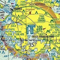
| Sectional chart |
|---|
|
CAUTION: Diagram may not be current
 Download PDF
of official airport diagram from the FAA
| Airport distance calculator |
|---|
|
|
| Sunrise and sunset |
|---|
|
Times for 23-May-2025
| | Local
(UTC-5) | | Zulu
(UTC) |
|---|
| Morning civil twilight | | 05:23 | | 10:23 |
| Sunrise | | 05:52 | | 10:52 |
| Sunset | | 20:01 | | 01:01 |
| Evening civil twilight | | 20:30 | | 01:30 |
|
| Current date and time |
|---|
| Zulu (UTC) | 23-May-2025 14:30:33 |
|---|
| Local (UTC-5) | 23-May-2025 09:30:33 |
|---|
|
| METAR |
|---|
| KMEM | 231354Z 09009KT 10SM BKN049 18/09 A3014 RMK AO2 SLP202 T01830094
|
KOLV
10nm E | 231350Z 06008G14KT 10SM OVC050 18/09 A3013
|
KAWM
14nm NW | 231353Z AUTO 07009KT 10SM BKN050 OVC060 18/11 A3013 RMK AO2 RAB1258E09 SLP200 P0000 T01830106
|
KNQA
19nm N | 231350Z 06006G14KT 10SM BKN050 18/09 A3013
|
|
| TAF |
|---|
| KMEM | 231127Z 2312/2418 03006KT P6SM SCT050 FM231500 05006KT P6SM SCT070 BKN120 FM240300 08006KT P6SM BKN050 PROB30 2405/2410 4SM -TSRA BKN045CB FM241000 10011G18KT 5SM -SHRA BKN035 OVC050 PROB30 2416/2418 4SM TSRA BKN025CB OVC035
|
|
| NOTAMs |
|---|
NOTAMs are issued by the DoD/FAA and will open in a separate window not controlled by AirNav.
|
|


