FAA INFORMATION EFFECTIVE 11 JUNE 2026
Location
| FAA Identifier: | N52 |
| Lat/Long: | 34-51-49.7400N 080-44-52.7400W
34-51.829000N 080-44.879000W
34.8638167,-80.7479833
(estimated) |
| Elevation: | 602 ft. / 183.5 m (surveyed) |
| Variation: | 07W (2000) |
| From city: | 3 miles S of WAXHAW, NC |
| Time zone: | UTC -4 (UTC -5 during Standard Time) |
| Zip code: | 28173 |
Airport Operations
| Airport use: | Open to the public |
| Activation date: | 02/1962 |
| Control tower: | no |
| ARTCC: | ATLANTA CENTER |
| FSS: | RALEIGH FLIGHT SERVICE STATION |
| NOTAMs facility: | RDU (NOTAM-D service available) |
| Attendance: | MON-FRI 0800-1700
UNATNDD MAJOR HOLS. |
| Wind indicator: | lighted |
| Segmented circle: | no |
| Lights: | ACTVT LIRL RWY 04/22 - CTAF. |
| Beacon: | white-green (lighted land airport)
ACTVT BEACON - CTAF. |
Airport Communications
| CTAF/UNICOM: | 123.0 |
| CHARLOTTE APPROACH: | 120.05 |
| CHARLOTTE DEPARTURE: | 120.05 |
| JOOLS STAR: | 135.6 |
| RASLN STAR: | 126.15 |
| WX AWOS-3 at LKR (10 nm SW): | 120.825 (803-286-6444) |
| WX ASOS at EQY (11 nm NE): | 135.775 (704-283-5185) |
| WX ASOS at UZA (17 nm NW): | 120.775 (803-306-5558) |
Nearby radio navigation aids
| VOR radial/distance | | VOR name | | Freq | | Var |
|---|
| CLTr158/22.0 | | CHARLOTTE VOR/DME | | 115.00 | | 05W |
| CTFr302/26.6 | | CHESTERFIELD VOR/DME | | 114.55 | | 03W |
| NDB name | | Hdg/Dist | | Freq | | Var | | ID |
|---|
| STONIA | | 140/28.1 | | 260 | | 06W | | GHJ | --. .... .--- |
Airport Services
| Parking: | tiedowns |
| Bottled oxygen: | NONE |
| Bulk oxygen: | NONE |
Runway Information
Runway 4/22
| Dimensions: | 3309 x 40 ft. / 1009 x 12 m |
| Surface: | asphalt, in good condition |
| Runway edge lights: | low intensity
RWY 04/22 NSTD LIRL. ONLY THREE END LGTS EACH SIDE OF RWYS & EACH SIDE OF DSPLCD THR. |
| Runway edge markings: | MRKGS SMALLER THAN STD DUE TO PVMT WIDTH. |
| RUNWAY 4 | | RUNWAY 22 |
| Latitude: | 34-51.614333N | | 34-52.044333N |
| Longitude: | 080-45.082667W | | 080-44.675333W |
| Elevation: | 602.0 ft. | | 599.0 ft. |
| Traffic pattern: | left | | left |
| Runway heading: | 045 magnetic, 038 true | | 225 magnetic, 218 true |
| Displaced threshold: | no | | 200 ft. |
| Markings: | NSTD, in good condition | | NSTD, in good condition |
| Runway end identifier lights: | no | | no |
| Touchdown point: | yes, no lights | | yes, no lights |
| Obstructions: | 50 ft. trees, 342 ft. from runway, 63 ft. right of centerline, 2:1 slope to clear
+15 FT WINDSOCK POLE 132 FT FROM THR OFFSET 74 FT LEFT OF CNTRLN; AND +51 FT TREES 0-200 FT FROM THR OFFSET 133 FT RIGHT OF CNTRLN; +51 FT TREES 0-200 FT FROM THR OFFSET 157 FT LEFT OF CNTRLN; AND +7 FT FENCE 0-200 FT FROM THR OFFSET 112 FT RIGHT AND OFFSET 120 FT LEFT OF CNTRLN. | | 59 ft. trees, 301 ft. from runway, 148 ft. right of centerline, 1:1 slope to clear
84 FT TREES 0-200 FT FM THR OFFSET 133 FT RIGHT; 65 FT TREES 0-200 FT FM THR OFFSET 107 FT LEFT. |
Airport Ownership and Management from official FAA records
| Ownership: | Privately-owned |
| Owner: | JAARS INC.
PO BOX 248
WAXHAW, NC 28173
Phone 704-843-6220 |
| Manager: | DAN MILLER
7710 JAARS ROAD
WAXHAW, NC 28173
Phone 704-843-6220 |
Additional Remarks
| - | RWY 04 HAS 5 FT DROP-OFF 150 FT FM THR, 0 BOTH. |
| - | TSNT TFC NOTE THAT ONLY JAARS PILOTS ARE PMTD TO USE NON-STD PATTERNS FOR T. |
| - | DEER ON AND INVOF ARPT. |
| - | RWY 04/22 20 FT DOWN SLOPE BTN ENDS. |
| - | SFC VARN IN RESA. |
| - | WIND CONDS PMTG AT NIGHT TKOF RWY 22 & LAND RWY 04. |
| - | TSNT TFC PROHIBITED FM LNDG ON GRASS PRACTICE AREAS. |
| - | FOR CD CTC CHARLOTTE APCH AT 704-359-0241. |
Instrument Procedures
NOTE: All procedures below are presented as PDF files. If you need a reader for these files, you should download the free Adobe Reader.NOT FOR NAVIGATION. Please procure official charts for flight.
FAA instrument procedures published for use from 11 June 2026 at 0901Z to 09 July 2026 at 0900z.
STARs - Standard Terminal Arrivals |
|---|
| JOOLS TWO (RNAV) **NEW** | |
download (275KB) |
| LIINN THREE **NEW** | |
2 pages:
[1] [2] (279KB) |
| MAJIC FOUR **NEW** | |
download (233KB) |
| RASLN THREE **NEW** | |
download (175KB) |
IAPs - Instrument Approach Procedures |
|---|
| RNAV (GPS) RWY 04 | |
download (197KB) |
| RNAV (GPS) RWY 22 | |
download (191KB) |
| NOTE: Special Take-Off Minimums/Departure Procedures apply | |
download (141KB) |
Other nearby airports with instrument procedures:
KLKR - Lancaster County Airport-Mc Whirter Field (10 nm SW)
KEQY - Charlotte-Monroe Executive Airport (11 nm NE)
KUZA - Rock Hill (York County) Airport-Bryant Field (17 nm NW)
KPYG - Pageland Airport (21 nm E)
KDCM - Chester Catawba Regional Airport (23 nm W)
|
|

Road maps at:
MapQuest
Bing
Google
| Aerial photo |
|---|
WARNING: Photo may not be current or correct

Do you have a better or more recent aerial photo of JAARS-Townsend Airport that you would like to share? If so, please send us your photo.
|
| Sectional chart |
|---|
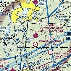
|
| Airport distance calculator |
|---|
|
|
| Sunrise and sunset |
|---|
|
Times for 12-Jun-2026
| | Local
(UTC-4) | | Zulu
(UTC) |
|---|
| Morning civil twilight | | 05:40 | | 09:40 |
| Sunrise | | 06:10 | | 10:10 |
| Sunset | | 20:36 | | 00:36 |
| Evening civil twilight | | 21:05 | | 01:05 |
|
| Current date and time |
|---|
| Zulu (UTC) | 12-Jun-2026 12:32:03 |
|---|
| Local (UTC-4) | 12-Jun-2026 08:32:03 |
|---|
|
| METAR |
|---|
KLKR
10nm SW | 121215Z AUTO 00000KT 10SM CLR 26/23 A2998 RMK AO2
|
KEQY
11nm NE | 121153Z AUTO 23006KT 10SM CLR 26/23 A2997 RMK AO2 SLP142 T02560228 10256 20228 53004
|
KUZA
16nm NW | 121154Z AUTO 28003KT 8SM CLR 26/23 A2998 RMK AO2 SLP134 T02560228 10261 20222 51005
|
|
| TAF |
|---|
KCLT
23nm NW | 121134Z 1212/1318 26004KT P6SM FEW250 FM121700 24007KT P6SM FEW060 SCT250 PROB30 1300/1303 VRB12G20KT 4SM -TSRA BKN050CB FM130300 32004KT P6SM SCT110 FM131500 04006KT P6SM SCT050
|
|
| NOTAMs |
|---|
NOTAMs are issued by the DoD/FAA and will open in a separate window not controlled by AirNav.
|
|

