FAA INFORMATION EFFECTIVE 14 MAY 2026
Location
| FAA Identifier: | UZA |
| Lat/Long: | 34-59-16.2000N 081-03-25.8000W
34-59.270000N 081-03.430000W
34.9878333,-81.0571667
(estimated) |
| Elevation: | 666.3 ft. / 203.1 m (surveyed) |
| Variation: | 05W (1990) |
| From city: | 4 miles NW of ROCK HILL, SC |
| Time zone: | UTC -4 (UTC -5 during Standard Time) |
| Zip code: | 29732 |
Airport Operations
| Airport use: | Open to the public |
| Activation date: | 01/1960 |
| Control tower: | no |
| ARTCC: | ATLANTA CENTER |
| FSS: | ANDERSON FLIGHT SERVICE STATION |
| NOTAMs facility: | UZA (NOTAM-D service available) |
| Attendance: | MON-FRI 0700-2000, ALL SAT-SUN 0800-1900 |
| Wind indicator: | lighted |
| Segmented circle: | yes |
| Lights: | DUSK-2300. MIRL RWY 02/20 & MALSR RWY 02 PRESET MED INTST DUSK-2300; TO INCR INTST & ACTVT AFTER 2300 - CTAF. |
| Beacon: | white-green (lighted land airport)
Operates sunset to sunrise. |
Airport Communications
| CTAF/UNICOM: | 123.05 |
| WX ASOS: | 120.775 (803-306-5558) |
| CHARLOTTE APPROACH: | 120.05 |
| CHARLOTTE DEPARTURE: | 120.05 |
| BARMY DP: | 120.05 |
| BEAVY DP: | 120.05 |
| BOBZY DP: | 120.05 |
| ESTRR DP: | 120.05 |
| ICONS DP: | 120.05 |
| JOJJO DP: | 120.05 |
| JOOLS STAR: | 135.6 |
| KERMIT DP: | 120.05 |
| KILNS DP: | 120.05 |
| KNIGHTS DP: | 120.05 |
| KRITR DP: | 120.05 |
| KWEEN DP: | 120.05 |
| LILLS DP: | 120.05 |
| RASLN STAR: | 126.15 |
| WEAZL DP: | 120.05 |
| WX ASOS at AKH (14 nm N): | 135.725 (704-868-9034) |
| WX AWOS-3 at DCM (14 nm SW): | 120.975 (803-385-2011) |
| WX ASOS at CLT (14 nm N): | PHONE 704-255-5973 |
| WX AWOS-3 at LKR (19 nm SE): | 120.825 (803-286-6444) |
Nearby radio navigation aids
| VOR radial/distance | | VOR name | | Freq | | Var |
|---|
| CLTr208/13.2 | | CHARLOTTE VOR/DME | | 115.00 | | 05W |
| NDB name | | Hdg/Dist | | Freq | | Var | | ID |
|---|
| RALLY | | 016/6.0 | | 227 | | 05W | | UZ | ..- --.. |
| STONIA | | 164/13.2 | | 260 | | 06W | | GHJ | --. .... .--- |
| UNION COUNTY | | 064/34.1 | | 326 | | 06W | | UOT | ..- --- - |
Airport Services
| Fuel available: | 100LL JET-A |
| Parking: | hangars and tiedowns |
| Airframe service: | MAJOR |
| Powerplant service: | MAJOR |
| Bottled oxygen: | HIGH |
| Bulk oxygen: | NONE |
Runway Information
Runway 2/20
| Dimensions: | 5500 x 100 ft. / 1676 x 30 m |
| Surface: | asphalt/grooved, in good condition |
| Weight bearing capacity: | | PCN 30 /F/C/X/T | | Single wheel: | 78.0 | | Double wheel: | 104.0 |
|
| Runway edge lights: | medium intensity |
| RUNWAY 2 | | RUNWAY 20 |
| Latitude: | 34-58.824892N | | 34-59.714242N |
| Longitude: | 081-03.537862W | | 081-03.323270W |
| Elevation: | 666.3 ft. | | 661.0 ft. |
| Traffic pattern: | left | | left |
| Runway heading: | 016 magnetic, 011 true | | 196 magnetic, 191 true |
| Markings: | precision, in good condition | | precision, in good condition |
| Visual slope indicator: | 2-light PAPI on left (3.00 degrees glide path) | | 2-light PAPI on left (3.00 degrees glide path) |
| Approach lights: | MALSR: 1,400 foot medium intensity approach lighting system with runway alignment indicator lights | | |
| Touchdown point: | yes, no lights | | yes, no lights |
| Instrument approach: | ILS/DME | | |
| Obstructions: | 82 ft. tree, 1589 ft. from runway, 725 ft. left of centerline, 16:1 slope to clear | | 87 ft. tree, 1825 ft. from runway, 523 ft. left of centerline, 18:1 slope to clear |
Airport Ownership and Management from official FAA records
| Ownership: | Publicly-owned |
| Owner: | CITY OF ROCK HILL
BOX 11706
ROCK HILL, SC 29731
Phone 803-329-7010 |
| Manager: | STEVEN A. GOULD JR., C.M.
550 AIRPORT RD, SUITE 205
ROCK HILL, SC 29732
Phone 803-329-5560
FBO - PILATUS AIRCRAFT USA, AARON COPE 803-366-5108. |
Additional Remarks
| - | WILDLIFE INVOF ARPT. |
| - | VOLUNTARY NOISE ABATEMENT PROC IN EFCT. |
| - | FOR CD IF UNA TO CTC ON FSS FREQ, CTC CHARLOTTE APCH AT 704-359-0241. |
| - | GCO AVBL ON FREQ 121.725 TO CHARLOTTE APCH. |
Instrument Procedures
NOTE: All procedures below are presented as PDF files. If you need a reader for these files, you should download the free Adobe Reader.NOT FOR NAVIGATION. Please procure official charts for flight.
FAA instrument procedures published for use from 14 May 2026 at 0901Z to 11 June 2026 at 0900Z.
STARs - Standard Terminal Arrivals |
|---|
| JOOLS TWO (RNAV) **NEW** | |
download (276KB) |
| LIINN THREE | |
2 pages:
[1] [2] (281KB) |
| MAJIC FOUR | |
download (235KB) |
| RASLN THREE | |
download (177KB) |
IAPs - Instrument Approach Procedures |
|---|
| ILS OR LOC RWY 02 | |
download (266KB) |
| RNAV (GPS) RWY 02 | |
download (250KB) |
| RNAV (GPS) RWY 20 | |
download (234KB) |
| NOTE: Special Alternate Minimums apply | |
download (168KB) |
Departure Procedures |
|---|
| BARMY SIX (RNAV) **NEW** | |
download (191KB) |
| BEAVY SEVEN (RNAV) **NEW** | |
download (175KB) |
| BOBZY SIX (RNAV) **NEW** | |
download (192KB) |
| ESTRR SIX (RNAV) **NEW** | |
download (161KB) |
| ICONS SIX (RNAV) **NEW** | |
download (163KB) |
| JOJJO SIX (RNAV) **NEW** | |
download (212KB) |
| KERMIT FIVE **NEW** | |
2 pages:
[1] [2] (348KB) |
| KILNS SIX (RNAV) **NEW** | |
download (164KB) |
| KNIGHTS FOUR **NEW** | |
2 pages:
[1] [2] (345KB) |
| KRITR SEVEN (RNAV) **NEW** | |
download (162KB) |
| KWEEN SIX (RNAV) **NEW** | |
download (163KB) |
| LILLS FOUR (RNAV) **NEW** | |
download (142KB) |
| WEAZL SIX (RNAV) **NEW** | |
download (153KB) |
| NOTE: Special Take-Off Minimums/Departure Procedures apply | |
download (365KB) |
Other nearby airports with instrument procedures:
KAKH - Gastonia Municipal Airport (14 nm N)
KDCM - Chester Catawba Regional Airport (14 nm SW)
KCLT - Charlotte/Douglas International Airport (14 nm N)
N52 - JAARS-Townsend Airport (17 nm SE)
KLKR - Lancaster County Airport-Mc Whirter Field (19 nm SE)
|
|

Road maps at:
MapQuest
Bing
Google
| Aerial photo |
|---|
WARNING: Photo may not be current or correct
 Photo taken 06-Oct-2012
looking southeast.
Photo taken 06-Oct-2012
looking southeast.
Do you have a better or more recent aerial photo of Rock Hill (York County) Airport-Bryant Field that you would like to share? If so, please send us your photo.
|
| Sectional chart |
|---|
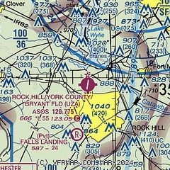
|
CAUTION: Diagram may not be current

| Airport distance calculator |
|---|
|
|
| Sunrise and sunset |
|---|
|
Times for 02-Jun-2026
| | Local
(UTC-4) | | Zulu
(UTC) |
|---|
| Morning civil twilight | | 05:43 | | 09:43 |
| Sunrise | | 06:12 | | 10:12 |
| Sunset | | 20:32 | | 00:32 |
| Evening civil twilight | | 21:01 | | 01:01 |
|
| Current date and time |
|---|
| Zulu (UTC) | 02-Jun-2026 23:14:23 |
|---|
| Local (UTC-4) | 02-Jun-2026 19:14:23 |
|---|
|
| METAR |
|---|
| KUZA | 022254Z AUTO 34004KT 10SM FEW110 21/13 A3018 RMK AO2 SLP212 T02060133
|
KAKH
14nm N | 022254Z AUTO 00000KT 10SM CLR 21/12 A3018 RMK AO2 SLP215 T02110122
|
KDCM
14nm SW | 022255Z AUTO 00000KT 10SM SCT120 19/13 A3019 RMK AO2
|
KCLT
15nm N | 022252Z 30003KT 10SM SCT110 SCT150 22/12 A3018 RMK AO2 SLP228 TCU DSNT NW-N T02170122
|
KLKR
19nm SE | 022255Z AUTO 30003KT 9SM FEW100 21/14 A3017 RMK AO2
|
|
| TAF |
|---|
KCLT
15nm N | 022154Z 0222/0324 35005KT P6SM FEW060 SCT120 FM030200 03006KT P6SM SCT250
|
|
| NOTAMs |
|---|
NOTAMs are issued by the DoD/FAA and will open in a separate window not controlled by AirNav.
|
|


