FAA INFORMATION EFFECTIVE 09 JULY 2026
Location
| FAA Identifier: | LKR |
| Lat/Long: | 34-43-22.4558N 080-51-16.5243W
34-43.374263N 080-51.275405W
34.7229044,-80.8545901
(estimated) |
| Elevation: | 485.9 ft. / 148.1 m (surveyed) |
| Variation: | 07W (2000) |
| From city: | 4 miles W of LANCASTER, SC |
| Time zone: | UTC -4 (UTC -5 during Standard Time) |
| Zip code: | 29720 |
Airport Operations
| Airport use: | Open to the public |
| Activation date: | 08/1970 |
| Control tower: | no |
| ARTCC: | ATLANTA CENTER |
| FSS: | ANDERSON FLIGHT SERVICE STATION |
| NOTAMs facility: | AND (NOTAM-D service available) |
| Attendance: | 0730-1500 |
| Wind indicator: | lighted |
| Segmented circle: | yes |
| Lights: | ACTVT REIL RWY 06 & 24; MIRL RWY 06/24 - CTAF. PAPI RWY 06 & 24 OPR CONSLY. |
| Beacon: | white-green (lighted land airport)
Operates sunset to sunrise. |
| Landing fee: | yes |
Airport Communications
| CTAF/UNICOM: | 122.725 |
| WX AWOS-3: | 120.825 (803-286-6444) |
| CHARLOTTE APPROACH: | 120.05 |
| CHARLOTTE DEPARTURE: | 120.05 |
| BARMY DP: | 120.05 |
| BEAVY DP: | 120.05 |
| BOBZY DP: | 120.05 |
| ESTRR DP: | 120.05 |
| ICONS DP: | 120.05 |
| JOJJO DP: | 120.05 |
| JOOLS STAR: | 135.6 |
| KERMIT DP: | 120.05 |
| KILNS DP: | 120.05 |
| KNIGHTS DP: | 120.05 |
| KRITR DP: | 120.05 |
| KWEEN DP: | 120.05 |
| LILLS DP: | 120.05 |
| RASLN STAR: | 126.15 |
| WEAZL DP: | 120.05 |
| WX AWOS-3 at DCM (17 nm W): | 120.975 (803-385-2011) |
| WX ASOS at UZA (19 nm NW): | 120.775 (803-306-5558) |
Nearby radio navigation aids
| VOR radial/distance | | VOR name | | Freq | | Var |
|---|
| CLTr175/28.4 | | CHARLOTTE VOR/DME | | 115.00 | | 05W |
| CTFr282/28.9 | | CHESTERFIELD VOR/DME | | 114.55 | | 03W |
| NDB name | | Hdg/Dist | | Freq | | Var | | ID |
|---|
| RALLY | | 137/15.0 | | 227 | | 05W | | UZ | ..- --.. |
| STONIA | | 158/31.8 | | 260 | | 06W | | GHJ | --. .... .--- |
| UNION COUNTY | | 093/38.9 | | 326 | | 06W | | UOT | ..- --- - |
Airport Services
| Fuel available: | 100LL JET-A
100LL:FOR FUEL AFT HRS CALL 803-285-1513 |
| Parking: | hangars and tiedowns |
| Airframe service: | NONE |
| Powerplant service: | NONE |
| Bulk oxygen: | NONE |
Runway Information
Runway 6/24
| Dimensions: | 6004 x 101 ft. / 1830 x 31 m |
| Surface: | concrete, in excellent condition |
| Weight bearing capacity: | | PCN 15 /R/B/X/T | | Single wheel: | 44.0 | | Double wheel: | 60.0 | | Double tandem: | 118.0 |
|
| Runway edge lights: | medium intensity |
| RUNWAY 6 | | RUNWAY 24 |
| Latitude: | 34-43.115825N | | 34-43.632700N |
| Longitude: | 080-51.786510W | | 080-50.764298W |
| Elevation: | 459.3 ft. | | 485.7 ft. |
| Traffic pattern: | left | | left |
| Runway heading: | 066 magnetic, 059 true | | 246 magnetic, 239 true |
| Displaced threshold: | 105 ft. | | no |
| Markings: | nonprecision, in good condition | | nonprecision, in good condition |
| Visual slope indicator: | 2-light PAPI on left (3.00 degrees glide path) | | 2-light PAPI on left (3.15 degrees glide path) |
| Runway end identifier lights: | yes | | yes |
| Touchdown point: | yes, no lights | | yes, no lights |
| Obstructions: | 17 ft. tree, 629 ft. from runway, 101 ft. left of centerline, 25:1 slope to clear | | 150 ft. tree, 4473 ft. from runway, 473 ft. left of centerline, 28:1 slope to clear |
Airport Ownership and Management from official FAA records
| Ownership: | Publicly-owned |
| Owner: | LANCASTER COUNTY
P.O.BOX 1809
LANCASTER, SC 29721
Phone 803-285-1565 |
| Manager: | PAUL MOSES
286 AVIATION BLVD, LANCASTER
LANCASTER, SC 29720
Phone (803) 285-1513 |
Additional Remarks
| - | 25 FT DROP; 250 FT FM THR RWY 06. |
| - | DEER ON & INVOF ARPT. |
| - | GCO AVBL ON FREQ 121.725 TO CHARLOTTE APCH. |
| - | SMALL ACFT MUST BE ON A TIE DOWN. |
| - | FOR CD CTC CHARLOTTE APCH AT 704-359-0241. |
| - | ARL APPLICATORS NOT PMTD DUE TO PAVEMENT CONDS. |
Instrument Procedures
NOTE: All procedures below are presented as PDF files. If you need a reader for these files, you should download the free Adobe Reader.NOT FOR NAVIGATION. Please procure official charts for flight.
FAA instrument procedures published for use from 09 July 2026 at 0901Z to 06 August 2026 at 0900Z.
STARs - Standard Terminal Arrivals |
|---|
| JOOLS THREE (RNAV) **NEW** | |
download (275KB) |
| LIINN THREE **NEW** | |
2 pages:
[1] [2] (279KB) |
| MAJIC FOUR **NEW** | |
download (234KB) |
| RASLN THREE **NEW** | |
download (176KB) |
IAPs - Instrument Approach Procedures |
|---|
| RNAV (GPS) RWY 06 | |
download (263KB) |
| RNAV (GPS) RWY 24 | |
download (258KB) |
| NOTE: Special Alternate Minimums apply | |
download (144KB) |
Departure Procedures |
|---|
| BARMY SEVEN (RNAV) **NEW** | |
download (190KB) |
| BEAVY EIGHT (RNAV) **NEW** | |
download (181KB) |
| BOBZY SEVEN (RNAV) **NEW** | |
download (195KB) |
| ESTRR SEVEN (RNAV) **NEW** | |
download (164KB) |
| ICONS SEVEN (RNAV) **NEW** | |
download (164KB) |
| JOJJO SEVEN (RNAV) **NEW** | |
download (215KB) |
| KERMIT SIX **NEW** | |
2 pages:
[1] [2] (351KB) |
| KILNS SEVEN (RNAV) **NEW** | |
download (164KB) |
| KNIGHTS FIVE **NEW** | |
2 pages:
[1] [2] (348KB) |
| KRITR EIGHT (RNAV) **NEW** | |
download (167KB) |
| KWEEN SEVEN (RNAV) **NEW** | |
download (166KB) |
| LILLS FIVE (RNAV) **NEW** | |
download (145KB) |
| WEAZL SEVEN (RNAV) **NEW** | |
download (154KB) |
| NOTE: Special Take-Off Minimums/Departure Procedures apply | |
download (365KB) |
Other nearby airports with instrument procedures:
N52 - JAARS-Townsend Airport (10 nm NE)
KDCM - Chester Catawba Regional Airport (17 nm W)
KUZA - Rock Hill (York County) Airport-Bryant Field (19 nm NW)
KEQY - Charlotte-Monroe Executive Airport (21 nm NE)
KPYG - Pageland Airport (25 nm E)
|
|

Road maps at:
MapQuest
Bing
Google
| Aerial photo |
|---|
WARNING: Photo may not be current or correct
 Photo by Tammy Scott
Photo taken 09-Sep-2012
looking northeast.
Photo by Tammy Scott
Photo taken 09-Sep-2012
looking northeast.
Do you have a better or more recent aerial photo of Lancaster County Airport-Mc Whirter Field that you would like to share? If so, please send us your photo.
|
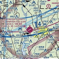
| Sectional chart |
|---|
|
| Airport distance calculator |
|---|
|
|
| Sunrise and sunset |
|---|
|
Times for 27-Jul-2026
| | Local
(UTC-4) | | Zulu
(UTC) |
|---|
| Morning civil twilight | | 06:03 | | 10:03 |
| Sunrise | | 06:31 | | 10:31 |
| Sunset | | 20:29 | | 00:29 |
| Evening civil twilight | | 20:57 | | 00:57 |
|
| Current date and time |
|---|
| Zulu (UTC) | 27-Jul-2026 15:03:20 |
|---|
| Local (UTC-4) | 27-Jul-2026 11:03:20 |
|---|
|
| METAR |
|---|
| KLKR | 271315Z AUTO 00000KT 10SM CLR 26/26 A2990 RMK AO2
|
KDCM
17nm W | 271315Z AUTO 00000KT 10SM CLR 27/23 A2991 RMK AO2 LTG DSNT SE
|
KUZA
18nm NW | 271254Z AUTO 00000KT 10SM FEW003 24/24 A2990 RMK AO2 SLP112 T02440239
|
|
| TAF |
|---|
KCLT
30nm N | 271343Z 2714/2818 VRB03KT P6SM SCT250 FM271800 34004KT P6SM FEW050 FM280000 18003KT P6SM SCT250 FM281400 22010G18KT P6SM FEW080 SCT150
|
|
| NOTAMs |
|---|
NOTAMs are issued by the DoD/FAA and will open in a separate window not controlled by AirNav.
|
|

