FAA INFORMATION EFFECTIVE 20 MARCH 2025
Location
| FAA Identifier: | NGT |
| Lat/Long: | 28-36-41.7897N 097-36-45.2533W
28-36.696495N 097-36.754222W
28.6116082,-97.6125704
(estimated) |
| Elevation: | 322 ft. / 98 m (estimated) |
| Variation: | 07E (1985) |
| From city: | 5 miles N of BERCLAIR, TX |
| Time zone: | UTC -5 (UTC -6 during Standard Time) |
| Zip code: | 77963 |
Airport Operations
| Airport use: | Private use. Permission required prior to landing |
| Activation date: | 09/2000 |
| Control tower: | no |
| ARTCC: | HOUSTON CENTER |
| FSS: | SAN ANGELO FLIGHT SERVICE STATION |
| NOTAMs facility: | SJT (NOTAM-D service available) |
| Attendance: | MON-FRI 1400-0400Z++ |
| Wind indicator: | lighted |
| Segmented circle: | no |
| Lights: | AVBL ONLY DURING HOURS OF OPERATION. |
Airport Communications
| CTAF: | 132.875 |
| WX ASOS: | 353.675 |
| WX AWOS-3 at BEA (18 nm SW): | 118.675 (361-362-7627) |
| WX AWOS-3PT at 2R9 (18 nm NW): | 118.45 (830-583-8080) |
- APCH/DEP CTL SVC PRVDD BY HOUSTON ARTCC (ZHU) ON FREQS 135.05/353.6 (VICTORIA RCAG).
Nearby radio navigation aids
| VOR radial/distance | | VOR name | | Freq | | Var |
|---|
| THXr069/29.1 | | THREE RIVERS VORTAC | | 111.40 | | 08E |
| VCTr237/37.6 | | VICTORIA VOR/DME | | 109.00 | | 06E |
Airport Services
| Oil available: | 307.075. |
| Bottled oxygen: | NONE |
| Bulk oxygen: | NONE |
Runway Information
Runway 17/35
| Dimensions: | 8001 x 150 ft. / 2439 x 46 m |
| Surface: | PEM, in excellent condition |
| Weight bearing capacity: | |
| Runway edge lights: | high intensity |
| RUNWAY 17 | | RUNWAY 35 |
| Latitude: | 28-37.076348N | | 28-35.775222N |
| Longitude: | 097-37.243220W | | 097-36.989352W |
| Elevation: | 321.6 ft. | | 297.7 ft. |
| Traffic pattern: | left | | left |
| Runway heading: | 163 magnetic, 170 true | | 343 magnetic, 350 true |
| Markings: | nonprecision, in good condition | | nonprecision, in good condition |
| Visual slope indicator: | 4-light PAPI on left (3.00 degrees glide path)
PAPI UNUSABLE BYD 8 DEGS RIGHT OF CNTRLN. | | 4-light PAPI on left (3.00 degrees glide path) |
| Touchdown point: | yes, lighted | | yes, lighted |
Runway 11/29
| Dimensions: | 8000 x 150 ft. / 2438 x 46 m |
| Surface: | PEM, in excellent condition
FIRST 1000 FT EACH RY END CONC; MIDDLE SECTION ASPH. |
| Weight bearing capacity: | |
| Runway edge lights: | high intensity |
| RUNWAY 11 | | RUNWAY 29 |
| Latitude: | 28-37.184615N | | 28-36.749862N |
| Longitude: | 097-37.098350W | | 097-35.685875W |
| Elevation: | 318.0 ft. | | 264.5 ft. |
| Traffic pattern: | left | | left |
| Runway heading: | 103 magnetic, 110 true | | 283 magnetic, 290 true |
| Markings: | nonprecision, in good condition | | nonprecision, in good condition |
| Visual slope indicator: | 4-light PAPI on left (3.00 degrees glide path) | | 4-light PAPI on left (3.00 degrees glide path) |
| Touchdown point: | yes, lighted | | yes, lighted |
| Obstructions: | 10 ft. brush, 200 ft. from runway, 74 ft. left of centerline
+10 FT BRUSH & TREES 0-200 FT 74 FT L. | | 10 ft. brush, 200 ft. from runway, 100 ft. left of centerline
+10 FT BRUSH & TREES 0-200 FT 90 FT R & 100 FT L. |
Airport Ownership and Management from official FAA records
| Ownership: | U.S. Navy |
| Owner: | U.S. NAVY
11001 D STREET SUITE 101, NAVAL AIR STATION
CORPUS CHRISTI, TX 78419
Phone 361-961-2505 |
| Manager: | DARNELL DAVIS
11001 D STREET SUITE 101, NAVAL AIR STATION
CORPUS CHRISTI, TX 78419
Phone 361-961-2247 |
Additional Remarks
| - | CAUTION: STUDENT TRAINING ACTIVITY, HI MID-AIR POTENTIAL, EXTREME VIGILANCE REQUIRED. |
| - | CAUTION: ALL ACFT CHECK-IN WITH RDO PRIOR TO ARRIVAL ON CTAF. |
| - | SERVICE: NO SERVICES AVBL. |
| - | OPR 1400Z++-SS MON-FRI. OPR OUTSIDE PUBL HR PROH. OTRS RQR PPR 72 HRS, FOR AFLD USE CTC CORPUS CHRISTI NAS BASE OPS C361-961-2505/2506/2507, DSN 861-2505/2507. PPR STRICTLY ENFORCED. TRAWING 4 EXCLUSIVE USE. |
| - | FOR CD CTC HOUSTON ARTCC AT 281-230-5622. |
Instrument Procedures
NOTE: All procedures below are presented as PDF files. If you need a reader for these files, you should download the free Adobe Reader.NOT FOR NAVIGATION. Please procure official charts for flight.
FAA instrument procedures published for use from 20 March 2025 at 0901Z to 17 April 2025 at 0900z.
IAPs - Instrument Approach Procedures |
|---|
| RNAV (GPS) RWY 11 | |
download (115KB) |
| RNAV (GPS) RWY 17 | |
download (115KB) |
| RNAV (GPS) RWY 29 | |
download (120KB) |
| RNAV (GPS) RWY 35 | |
download (117KB) |
Other nearby airports with instrument procedures:
TX2 - Chase Field Industrial Airport (15 nm S)
KBEA - Beeville Municipal Airport (18 nm SW)
2R9 - Kenedy Regional Airport (18 nm NW)
8T6 - Live Oak County Airport (30 nm SW)
T69 - Sinton Airport (35 nm S)
|
|

Road maps at:
MapQuest
Bing
Google
| Aerial photo |
|---|
WARNING: Photo may not be current or correct
 Photo by David L. Hutchins, Corpus Christi, TX
Photo taken 14-Jan-2006
Photo by David L. Hutchins, Corpus Christi, TX
Photo taken 14-Jan-2006
Do you have a better or more recent aerial photo of Goliad Naval Outlying Field that you would like to share? If so, please send us your photo.
|
| Sectional chart |
|---|
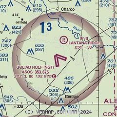
|
| Airport distance calculator |
|---|
|
|
| Sunrise and sunset |
|---|
|
Times for 08-Apr-2025
| | Local
(UTC-5) | | Zulu
(UTC) |
|---|
| Morning civil twilight | | 06:50 | | 11:50 |
| Sunrise | | 07:14 | | 12:14 |
| Sunset | | 19:51 | | 00:51 |
| Evening civil twilight | | 20:15 | | 01:15 |
|
| Current date and time |
|---|
| Zulu (UTC) | 08-Apr-2025 08:57:56 |
|---|
| Local (UTC-5) | 08-Apr-2025 03:57:56 |
|---|
|
| METAR |
|---|
KBEA
18nm SW | 080855Z AUTO 07003KT 10SM CLR 10/00 A3012 RMK AO2 T00960002
|
K2R9
18nm NW | 080835Z AUTO 00000KT 10SM CLR 07/05 A3014 RMK AO2 T00700048
|
KT69
35nm S | 080835Z AUTO 00000KT 10SM CLR 07/06 A3012 RMK A01
|
|
| TAF |
|---|
KVCT
39nm NE | 080520Z 0806/0906 VRB06KT P6SM SKC
|
|
| NOTAMs |
|---|
NOTAMs are issued by the DoD/FAA and will open in a separate window not controlled by AirNav.
|
|


